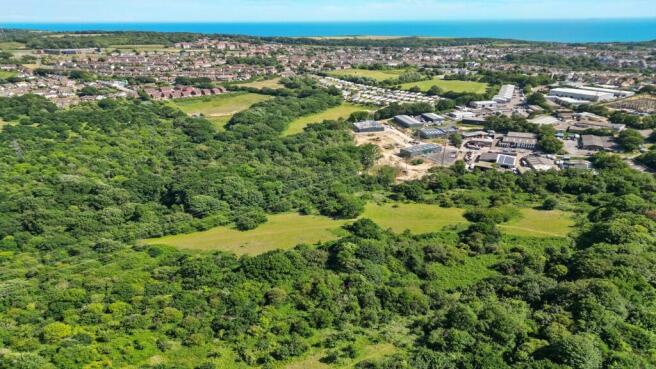
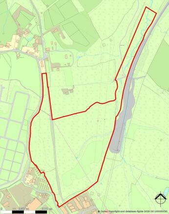

Land On East Side Of, Ivyhouse Lane, Hastings, TN35 4NN
- SIZE AVAILABLE
1,350,360 sq ft
125,453 sq m
- SECTOR
Commercial development for sale
Key features
- 31 acres (12.55 ha)
- 14.5 acres (5.87 ha) allocated for employment
- The site is within the Hastings Borough Council Management Plan (reference HOV11) and Rother District Council Development and Site Allocation Plan (reference HAS3).
- Potential scope to redevelop for alternative uses including but not limited to residential or industrial STPP.
- Option to purchase the entirety or parts.
Description
14.5 acres (5.87ha) allocated for employment.
The site is within the Hastings Borough Council Management Plan (reference HOV11) and
Rother District Council Development and Site Allocation Plan (reference HAS3).
Potential scope to redevelop for alternative uses including but not limited to residential or
industrial STPP.
Option to purchase the entirety or parts.
A21 approximately 2 miles west.
Ivyhouse Lane connects with The Ridge, a main thoroughfare providing access across the
northern periphery of Hastings & St. Leonards-on-Sea.
Adjoining Ivyhouse Lane Industrial Estate.
The site is surrounded by fields to the north, east and west.
Hastings Train Station 3 miles south.
Brochures
Land On East Side Of, Ivyhouse Lane, Hastings, TN35 4NN

NEAREST STATIONS
Distances are straight line measurements from the centre of the postcode- Ore Station1.0 miles
- Three Oaks Station1.5 miles
- Hastings Station1.9 miles
Notes
Disclaimer - Property reference 26259FH. The information displayed about this property comprises a property advertisement. Rightmove.co.uk makes no warranty as to the accuracy or completeness of the advertisement or any linked or associated information, and Rightmove has no control over the content. This property advertisement does not constitute property particulars. The information is provided and maintained by SHW, East Sussex. Please contact the selling agent or developer directly to obtain any information which may be available under the terms of The Energy Performance of Buildings (Certificates and Inspections) (England and Wales) Regulations 2007 or the Home Report if in relation to a residential property in Scotland.
Map data ©OpenStreetMap contributors.