Montagu Street, Kettering
- PROPERTY TYPE
Residential Development
- SIZE
Ask agent
Description
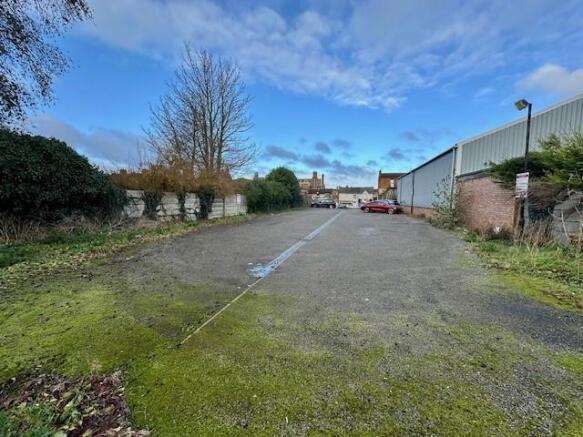
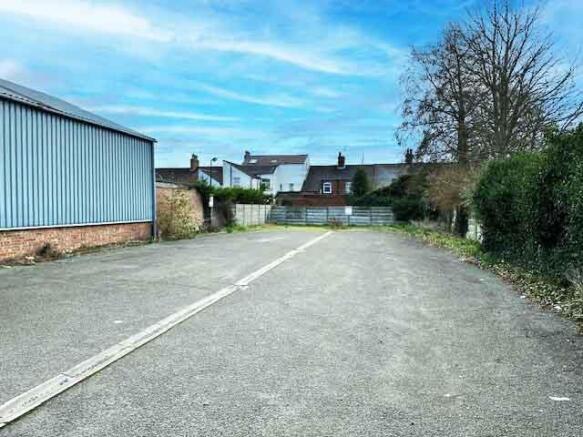
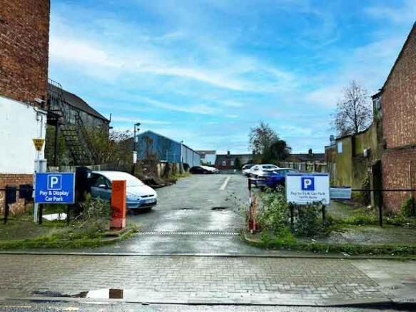
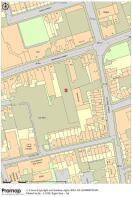
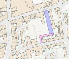
Location: - The site, formerly 40 and 42 Montagu Street, has a frontage and vehicular access to Montagu Street, on the north eastern edge of the town centre.
Kettering is located on the A14 and A43. It has a main line railway station with regular London St Pancras service and is due for expansion under proposals to significantly increase the town population by 2030 as part of the Milton Keynes and South Midlands Growth Area.
Description - Potential town centre freehold development site of approximately 0.113 Ha (0.279 acres.)
The site is presently used as a car park with vehicular access from Montagu Street. It is registered under two titles, NN82225 which fronts Montagu is within the Kettering town centre Conservation Area. The rear of the site, NN54208, which has an additional vehicular right of way from School Lane has an authorised use as a car park or any other use with consent not to be unreasonably withheld or delayed.
All mains services are believed to be present in Montagu Street but prospective purchasers should check with the appropriate service providers.
The site is considered to have potential for high density residential development, subject to obtaining planning consent from North Northants Council. There have been recent planning approvals nearby including the adjoining site, a former public house, which gained planning in 2021 NK/2021/0654 for a 3 storey side and 2 storey rear extensions to create 15 one and two bedroom apartments and enlarge the existing retail unit.
Planning - The site appears to have been used as a car park since the 1980’s. The last known consent in 1991 was for lamp standards to illuminate the car park KE/1991/0749. Part of the site is located in the Conservation Area.
Potential Use: - The site has potential for high density residential development, subject to planning consent and consideration of restrictive covenants as referred to below – please ask for copy OC1’s for a more detailed description.
The adjoining site to the east, which has no connection to this sale, a former public house, gained planning approval 23 July 2021 under application number NK/2021/0654 for Three storey side and two storey rear extensions to create 15 no. one and two bedroom apartments and enlarge the existing retail unit. This is mentioned to illustrate how planners were considering development of this area at that time.
Rateable Value - The site is currently let on licence as a private car park with a 2023 Rateable Value of £7,900.
Land Registration - NNNN54208 and NN82225. Title number NN82225 (this title should be read in conjunction with a registered transfer dated 05.08.1985) which directly fronts Montagu Street and is within Kettering town centre conservation area. OC1 title and OC1 plans and the transfer refrred to are available by email from the agents.
Tenure - The site is available Freehold at £500,000
Viewing: - Strictly by appointment with the Joint Agents, either
Lucas Sales & Lettings or David Walker Commercial, 9 Rushton Road,, Wilbarston, Market Harborough LE16 8QL
Call David Walker or
Brochures
Montagu Street, KetteringBrochureMontagu Street, Kettering

NEAREST STATIONS
Distances are straight line measurements from the centre of the postcode- Kettering Station0.7 miles


Notes
Disclaimer - Property reference 33670478. The information displayed about this property comprises a property advertisement. Rightmove.co.uk makes no warranty as to the accuracy or completeness of the advertisement or any linked or associated information, and Rightmove has no control over the content. This property advertisement does not constitute property particulars. The information is provided and maintained by Lucas Estate Agents, Kettering. Please contact the selling agent or developer directly to obtain any information which may be available under the terms of The Energy Performance of Buildings (Certificates and Inspections) (England and Wales) Regulations 2007 or the Home Report if in relation to a residential property in Scotland.
Map data ©OpenStreetMap contributors.