

Land At Eye, Eyebury Road, Eye, Peterborough, PE6

- PROPERTY TYPE
Land
- SIZE
10,315,008 sq ft
958,296 sq m
Key features
- Mixed commercial and agricultural freehold investment
- Former sand & gravel quarry restored to a mix of arable and grassland, including a lake and Wildlife Corridor
- Company owner for 22 years retiring from business
- The property is sold subject to a commercial lease in favour of Biffa Waste Services Limited for landfilling and restoration until June 2031
- Part of the property is subject to an Agricultural Holdings Act Tenancy, being agricultural land including a lake
- Rental income for 2024 amounted to approximately £236,530
- In a strategic location 4 miles northeast of Peterborough City centre (600m from nearest commercial properties in Peterborough)
- Approximately 236.80 acres (95.83 hectares)
- Potential for log cabin development within the Wildlife Corridor and adjacent to the lake, subject to obtaining building regulations
Description
Description
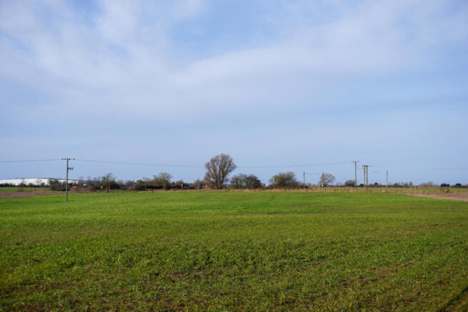
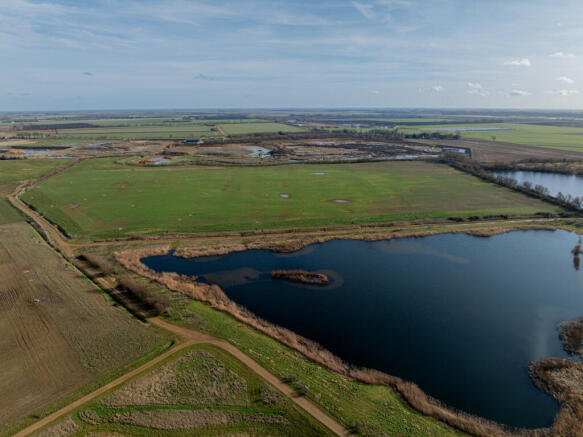
The land at Eye has been subject to sand & gravel extraction and landfilling for over 40 years. Currently commercially exploitable mineral reserves have been exhausted with the subsequent void space tipped with mainly non-hazardous waste from commercial and industrial sources as well as some household sources, and stable non-reactive hazardous waste (SNRHW).The northern and central areas of the site have been completely restored to majority arable land, but also includes a lake extending to approximately 13.01 acres(5.26 hectares). To the east of the lake there is a topsoil mound. The Soil Survey of England and Wales records the soils as of the Shabbington association suitable for winter cereals and grassland. Most of the southern area of the site is currently being restored to grassland. The restored land form will be domed allowing views over the surrounding area.
Landfill gas from all the filled areas is captured and piped into a landfill gas generator on the adjoining Biffa freehold. Royalty income from this use of the gas provides a useful income stream for the property.
The southern area has been engineered to allow for settlement, usually up to 20% from original levels. This is apart from that cell filled with SNRHW which will not shrink to the same extent.
The land to be restored is being capped with plastic and approximately 1 metre of soils laid on top, 200 to 300mm of which is topsoil. Along the eastern boundary of the southern area is a wetland complex comprising a Wildlife Corridor.
Various land uses within this area include species-rich neutral grassland, woodland and scrub, larger open water expanses, seasonal waterbodies and reedbeds. Adjacent to the southern area on Biffa’s freehold land are some miscanthus beds which are utilised for leachate treatment. Beyond this to the south and southwest is agricultural land farmed as part of the Agricultural Holdings Act Tenancy. The lake is included within this tenancy.
LANDFILL
The landfilled areas have had pipework installed so that landfill gas can be harvested and used to generate electricity via gas engines. The compound including the gas engines are situated on adjacent land owned by Biffa Waste Services. Biffa pay a royalty to the Vendor based on a percentage of income generated from the sale of the electricity to the National Grid. Summary of income received back to 2011 and agas curve model showing forecast gas outputs is available within the Data Room. It is undetermined but there is potentially some void space remaining on the Vendors land within the southern area of the property, which is consented for inert fill. The consented void includes land belonging to Biffa.
ENVIRONMENTAL PERMIT
Waste management operations are required to have an Environmental Permit as issued by the Environment Agency (EA). A Permit was issued to Biffa Waste Services Limited on 9 May 2018 (ref. EPR/BP3537PP) to permit the receipt, handling, storage and disposal of non-hazardous, SNRHW and inert waste at the property, the utilisation of landfill gas for energy recovery, the storage & treatment of leachate and a series of other related operations. This permit as well as other permits benefitting the immediate surrounding operations are held within the Data Room.
Location
The property is situated to the north east of Peterborough and approximately 450 metres southeast of the development boundary of Eye village. The property benefits from multiple points of access directly from Eyebury Road, which runs south from the A47 to the north of Eye to Oxney Road which in turn provides access west to Peterborough’s eastern industries area and the A15 circular road east of Peterborough.
Access to the northern half of the property is shared with the owner of Tanholt Farm whereas access to the southern half of the property is shared with Biffa Waste Services Limited.
The land sits in a rural location with surroundings being predominantly arable fields divided by drains. The land here and in the immediate vicinity is mainly classified as Grade 3 on the Agricultural Land Classification Map, with some Grade 2 further to the south and east. To the west of the site is land owned by Biffa who have undertaken enabling works for an open windrow composting facility. Peterborough has a wide range of amenities including, shops, schools, restaurants and leisure facilities. Peterborough train station lies 4 miles from the property where there are regular trains running from Peterborough to London(Kings Cross), with the fastest trains taking approximately 50 minutes.
Acreage: 236.8 Acres
Additional Info
Viewings will be 27th February and 26th March 2025
Photographs taken: December 2024
Particulars: February 2025
Local Authority: Peterborough City Council
For further information please contact Tom Banks. Direct dial: . Email: tom.
Brochures
Web DetailsLand At Eye, Eyebury Road, Eye, Peterborough, PE6

NEAREST STATIONS
Distances are straight line measurements from the centre of the postcode- Peterborough Station3.3 miles
- Whittlesea Station4.4 miles
Notes
Disclaimer - Property reference LIR240141. The information displayed about this property comprises a property advertisement. Rightmove.co.uk makes no warranty as to the accuracy or completeness of the advertisement or any linked or associated information, and Rightmove has no control over the content. This property advertisement does not constitute property particulars. The information is provided and maintained by Savills Rural Sales, Lincoln. Please contact the selling agent or developer directly to obtain any information which may be available under the terms of The Energy Performance of Buildings (Certificates and Inspections) (England and Wales) Regulations 2007 or the Home Report if in relation to a residential property in Scotland.
Map data ©OpenStreetMap contributors.