
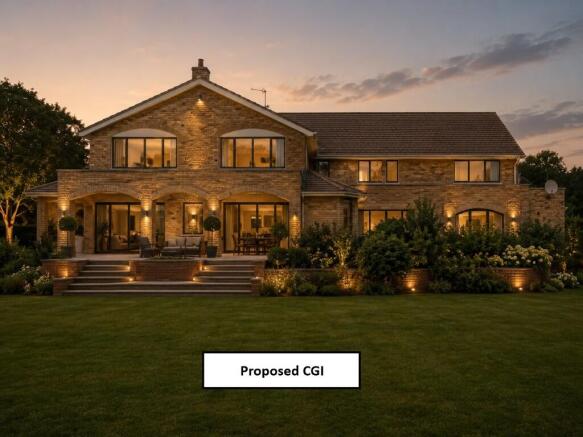

Ruxbury Road, Chertsey, Surrey, KT16
- PROPERTY TYPE
Detached
- BEDROOMS
8
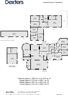
- SIZE
19,741 sq ft
1,834 sq m
- TENUREDescribes how you own a property. There are different types of tenure - freehold, leasehold, and commonhold.Read more about tenure in our glossary page.
Freehold
Key features
- Residential development opportunity
- Freehold plot of circa 1,834 sqm (19,741 sq ft)
- Detached eight-bedroom house of circa 569 sqm (6,124 sq ft)
- Potential to either refurbish & extend the existing building, or to redevelop it
- Part of the Unencumbered Freehold
- Located within a Private Road
Description
Once a grand detached family house the property would benefit from being modernised and redecorated. Within the freehold there is also a separate double-garage and workshop, a separate stable block, swimming pool and swimming pool outbuilding.
The freehold offers the opportunity to either refurbish and enhance the existing building, or to redevelop the site following the demolition of the existing house (subject to securing the necessary planning consents).
Located within the historical town of Chertsey with the Borough of Runnymede, the property is with 1 kilometre of the Chertsey train station providing direct trains to London Waterloo. Chertsey town centre is within 1 kilometre, providing a plethora of shops, coffee shops, restaurants and public houses including Sainsbury's, Aldi, Ohanas Café Bistro and Pianillo Italian Restaurant & Bar.
Chertsey offers a great selection of public and private schools that have secured an Outstanding Ofstead Inspection Rating, including Meath School, Pyrcroft Grange Primary School and Salesian School. The 'open green space' of St Ann's Hill Park and Nature Trails located within 500 metres.
Tenure - Part of the Unencumbered Freehold HM Land Registry Title Number SY345464
Brochures
Brochure- COUNCIL TAXA payment made to your local authority in order to pay for local services like schools, libraries, and refuse collection. The amount you pay depends on the value of the property.Read more about council Tax in our glossary page.
- Ask agent
- PARKINGDetails of how and where vehicles can be parked, and any associated costs.Read more about parking in our glossary page.
- Yes
- GARDENA property has access to an outdoor space, which could be private or shared.
- Ask agent
- ACCESSIBILITYHow a property has been adapted to meet the needs of vulnerable or disabled individuals.Read more about accessibility in our glossary page.
- Ask agent

Add an important place to see how long it'd take to get there from our property listings.
__mins driving to your place
Affordability
About Dexters Development & Investment, South London
Dexters Wimbledon, 12 The Broadway London SW19 1RFGet an instant, personalised result:
- Show sellers you’re serious
- Secure viewings faster with agents
- No impact on your credit score
Notes
Staying secure when looking for property
Ensure you're up to date with our latest advice on how to avoid fraud or scams when looking for property online.
Visit our security centre to find out moreDisclaimer - Property reference VillaSantaMaria2. The information displayed about this property comprises a property advertisement. Rightmove.co.uk makes no warranty as to the accuracy or completeness of the advertisement or any linked or associated information, and Rightmove has no control over the content. This property advertisement does not constitute property particulars. The information is provided and maintained by Dexters Development & Investment, South London. Please contact the selling agent or developer directly to obtain any information which may be available under the terms of The Energy Performance of Buildings (Certificates and Inspections) (England and Wales) Regulations 2007 or the Home Report if in relation to a residential property in Scotland.
*This is the average speed from the provider with the fastest broadband package available at this postcode. The average speed displayed is based on the download speeds of at least 50% of customers at peak time (8pm to 10pm). Fibre/cable services at the postcode are subject to availability and may differ between properties within a postcode. Speeds can be affected by a range of technical and environmental factors. The speed at the property may be lower than that listed above. You can check the estimated speed and confirm availability to a property prior to purchasing on the broadband provider's website. Providers may increase charges. The information is provided and maintained by Decision Technologies Limited. **This is indicative only and based on a 2-person household with multiple devices and simultaneous usage. Broadband performance is affected by multiple factors including number of occupants and devices, simultaneous usage, router range etc. For more information speak to your broadband provider.