
Village Lane, WA4
- PROPERTY TYPE
Farm Land
- SIZE
Ask agent
Key features
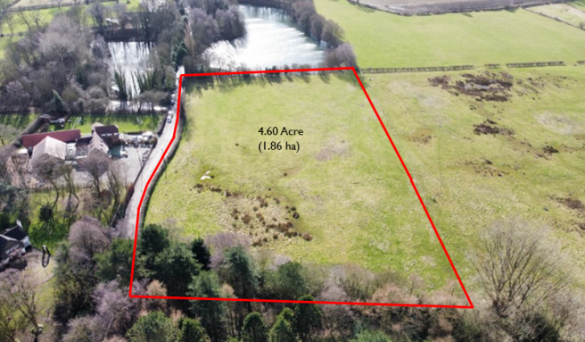
- 4.60 Acres of Permanent Pasture
- Gated Access of Village Lane
- Rural Location
Description
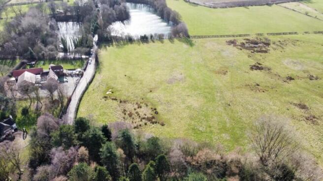
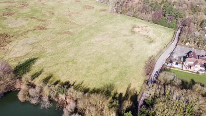
Located in the rural village of Higher Whitley, this approximately 4.60 acres (1.86 ha) block of permanent pasture provides an excellent opportunity for both agricultural and equestrian buyers. The land is well located opposite Whitley village school and the village hall. The land is well-fenced on all sides with good access off Village Lane.
DIRECTIONS
Travelling from the M56 motorway, exit at Junction 10 and take the A49 Tarporley Road towards Lower Whitley. Travel approximately 1 mile until a right-hand turn for 'Raddel Lane'. Once on 'Raddel Lane', travel half a mile until you reach the crossroads, turning right onto Village Lane the land is then on your right, indicated by the Rostons sale bored.
VIEWINGS
The land can be viewed at any reasonable time without prior appointment with the selling agent. We request that you take a copy of these sales details with you when viewing the land.
TENURE & TITLE
Freehold
OVERAGE
The land will be sold subject to an overage provision where the vendor will be entitled to 30% of the uplift in value resulting in any use other than agricultural or equestrian. This will be in place for 25 years. This will be triggered upon the grant of planning or if any change of use is implemented.
SERVICES
None
SOIL TYPE LAND GRADE
According to the Cranfield Soil and Agri-food Institute (Soilscapes of England & Wales), the soil is classed as "Soilscape 10" described as Freely draining slightly acidic sandy soil. The land is Grade 3 (Land Classification Series for England & Wales) (Grade 1 - best, Grade 5 - worst).
FENCING & GATEWAY
The land is fenced on all sides, there is a gateway in the south-west corner. No access is permitted through this gateway and will be removed before completion of sale.
TOWN AND COUNTRY PLANNING ACT
The property not withstanding any description contained in these particulars, is sold subject to any development plan, tree preservation order, town planning scheme or agreement, resolution or notice.
SALE PLAN AND PARTICULARS
The sale plan is based on the Ordnance Survey sheet. Prospective purchasers should check the contract documents. The purchasers shall raise no objection or query in respect of any variation between the physical boundaries and the Ordnance Survey sheet plan. The plans are strictly for
identification purposes only.
MONEY LAUNDERING LEGISLATION
Rostons Ltd must comply with Anti Money Laundering legislation. As part of the requirements, Rostons must obtain evidence of the identity & proof of address of potential buyers.
Prior to an offer being accepted, all parties who are purchasing must provide the evidence.
EASEMENTS, WAYLEAVES AND RIGHTS OF WAY
The land is sold subject to and with the benefit of all public and private rights of way, lights, drainage, cable, pylons or other easements, restrictions or obligations whether or not the same are described in these particulars of sale.
SITUATION
Located in the rural village of Whitely with easy access to A49
Tarporley Road and M56
ACCESS
The land can be accessed via the gateway off Village Lane
SELLING AGENTS
Jack Jones
Rostons Ltd
West View House
Hatton Heath
Chester
CH3 9AU
Tel:
Email:
Brochures
Brochure 1Village Lane, WA4

NEAREST STATIONS
Distances are straight line measurements from the centre of the postcode- Acton Bridge Station3.5 miles
- Runcorn East Station3.8 miles
- Greenbank Station4.7 miles

About Rostons, Hatton Heath
West View House Whitchurch Road, Hatton Heath, CH3 9AU
Notes
Disclaimer - Property reference CP16427. The information displayed about this property comprises a property advertisement. Rightmove.co.uk makes no warranty as to the accuracy or completeness of the advertisement or any linked or associated information, and Rightmove has no control over the content. This property advertisement does not constitute property particulars. The information is provided and maintained by Rostons, Hatton Heath. Please contact the selling agent or developer directly to obtain any information which may be available under the terms of The Energy Performance of Buildings (Certificates and Inspections) (England and Wales) Regulations 2007 or the Home Report if in relation to a residential property in Scotland.
Map data ©OpenStreetMap contributors.