
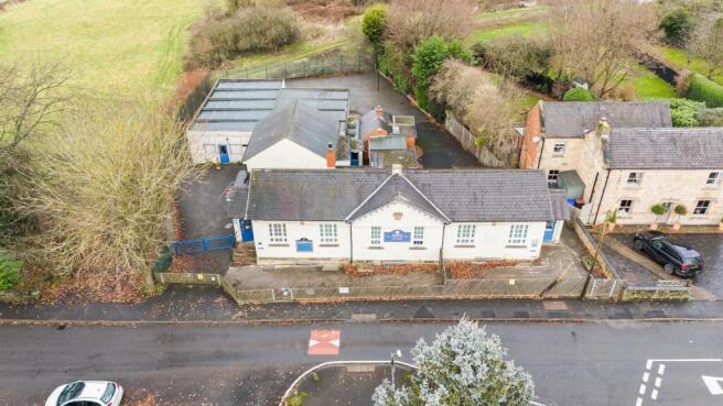
The Former Breadsall Primary School
- PROPERTY TYPE
Residential Development
- SIZE
3,885 sq ft
361 sq m
Key features
- Former School
- Potential for Conversion or Development (subject to planning)
Description
The Former Breadsall Primary School, is a unique opportunity to acquire a Former School situated in a highly sought-after location. This former school, built in 1837, offers potential for conversion or redevelopment (subject to planning). Alternatively, the property is suitable for continued use within Use Class F1.
Location - The Former Breadsall Primary School is located on Moor Road on the northeastern edge of the village of Breadsall. The village is almost contiguous with both Derby to the south and southeast and Little Eaton to the north.
Viewings - All viewings will need to be accompanied and arranged with the agents in advance.
It should be noted that no onsite parking will be available, therefore, viewing parties are advised to locate on-street parking prior to viewing the property.
Further Information - For any further enquiries please contact the agents.
James Holgate
James.
Peter Chennells
Peter.
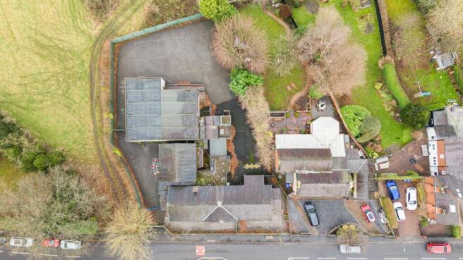
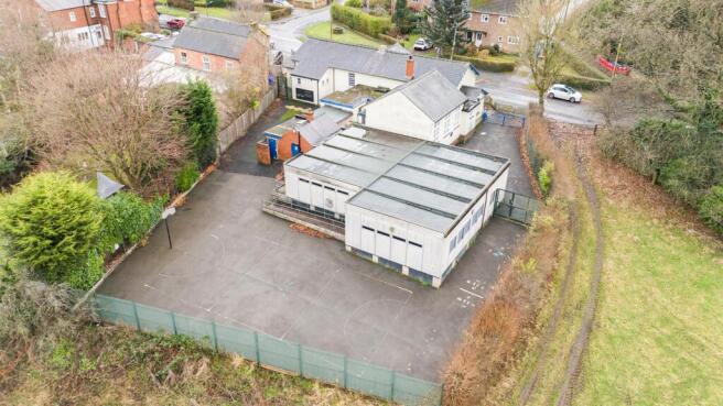
Description - The Former School site totals 0.33 acres (1,347m2) or thereabouts, comprising a substantial single-story purpose-built Victorian school building, built in 1837 with a second modern block (Block 2) and a tarmac playground the rear. The main block is of brick and stone construction with an external render under a pitched slate roof, block 2 is a prefabricated modular block. The total gross Internal (GIA) area is approximately 361m2 (3885 ft2) and is further described below.
All main services are connected and the property benefits from gas fired central heating.
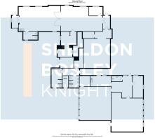
Accommodation -
Block 1: - 215.16m (705'11") - Hall
Classrooms 1
Classroom 2
Office
Back Hall
Toilets
Store 1
Classroom/Hall
Kitchen
External Store
Store 2
Toilet block
Block 2 - 146.05 (479'1") - Office
Hall
Toilet
Office/Store
Classroom 1 with store
Classroom 2 with store
Planning - All the property is within the Village housing development envelope and within the the Breadsall Conservation Areas.
All interested parties should complete their own planning enquiries.
Use And Classification - It is assumed that the property falls within Class F1.
Epc - The property has been assessed with an EPC rating of 'E' (110).
Tenure - The property is offered for sale freehold with vacant possession on completion.
The majority of the property is not registered with the land registry.
Part of the Property is owned by Derbyshire County Council DY251254
Services - We understand that the property is served with mains electric, gas and water.
Fixtures And Fittings - The School is to be sold with all fixtures and fittings.
Business Rates - The Property is not currently rated for Business Rates.
Method Of Sale - Best offers to be received by 12 Noon on Wednesday 2nd July 2025
Fees - The Purchaser will be responsible for paying the vendors agents fees at 1.5% +VAT of the sale price agreed.
Additionally the purchaser contribute £5,000 +VAT towards the vendors solicitors fees.
Vat - In the event that any part of the property is subject to VAT this will be payable by the purchaser in addition to the purchase price.
Local Authority - Ewash Borough Council
Town Hall, Wharncliffe Road, Ilkeston, Derbyshire, DE7 5RP
Agents Notice - For clarification, Andrew Granger & Co wish to inform interested parties that we have prepared these particulars as a general guide.
These particulars were prepared in August 2024
Brochures
The Former Breadsall Primary SchoolThe Former Breadsall Primary School

NEAREST STATIONS
Distances are straight line measurements from the centre of the postcode- Derby Station2.7 miles
- Duffield Station2.8 miles
- Spondon Station3.4 miles

Notes
Disclaimer - Property reference 33740229. The information displayed about this property comprises a property advertisement. Rightmove.co.uk makes no warranty as to the accuracy or completeness of the advertisement or any linked or associated information, and Rightmove has no control over the content. This property advertisement does not constitute property particulars. The information is provided and maintained by Andrew Granger, Loughborough. Please contact the selling agent or developer directly to obtain any information which may be available under the terms of The Energy Performance of Buildings (Certificates and Inspections) (England and Wales) Regulations 2007 or the Home Report if in relation to a residential property in Scotland.
Map data ©OpenStreetMap contributors.