
Wemberham Lane, Yatton, North Somerset, BS49
- PROPERTY TYPE
Land
- SIZE
121,532 sq ft
11,291 sq m
Key features
- 2.79 acres in total
- Pasture land
- Two wooden framed buildings
Description
Tender deadline 12 noon Tuesday 6th May 2025
Please request Tender Form from the agent
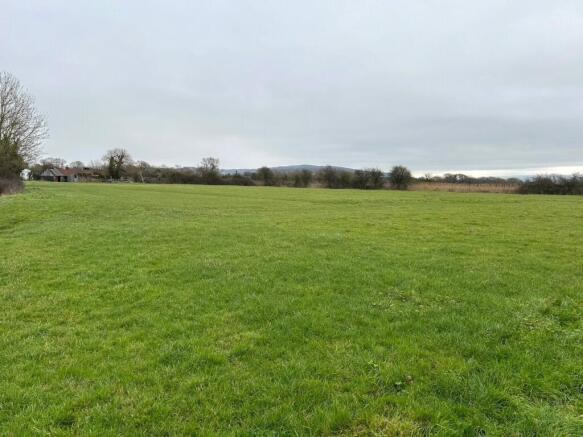
A unique opportunity to acquire a parcel of level pasture land and buildings situated on the outskirts of the prosperous village of Yatton, North Somerset.
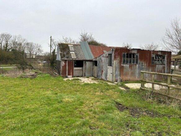
The land as a whole extends to 2.79 acres (1.13ha) which comprises two wooden framed buildings with an adjoining concrete apron, an area of hardstanding and a parcel of level pasture land.
The land offers potential purchasers a wealth of
opportunity for alternative uses such as, amenity, equestrian and small scale development, subject to obtaining the necessary statutory consents.
DESCRIPTION
A unique opportunity to acquire a parcel of level pasture land and buildings situated on the outskirts of the prosperous village of Yatton, North Somerset. The land has excellent views over the North Somerset Moors and the Mendip Hills National Landscape to the south.
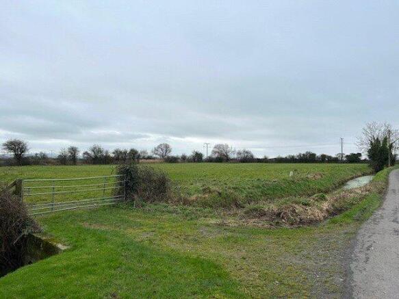
The land as a whole extends to 2.79 acres (1.13ha) which comprises two wooden framed buildings with an adjoining concrete apron, an area of hardstanding and a parcel of level pasture land. The land offers potential purchasers a wealth of opportunity for alternative uses such as, amenity, equestrian and small scale development, subject to obtaining the necessary statutory consents.
The Buildings over the years have been sub-divided and used as stabling and benefit from concreted floors, rainwater goods, corrugated tin sides and part corrugated tin and part asbestos sheeted roofs. A concrete apron and hardstanding area extends the perimeter of the buildings and leads to the gated access point off Wemberham Lane to the north. The internal measurements of the buildings are as follows:
Building 1A: 3.60m x 4.55m
Building 1B: 5.6m x 4.55m
Building 2: 5.6m x 4.9m
The pasture land extends to approximately to 2.66 acres (1.08ha) or thereabouts excluding the buildings, and is bordered by mature hedgerows boundaries to the east, south and west and a drainage rhyne to the north. The southern boundary runs parallel to the railway line and benefits from secure metal stock proof fencing.
The land is classified as Grade III according to the
DEFRA Land Classification Map.
DIRECTIONS
From the village of Yatton proceed north along the High Street for approximately 0.5 miles and turn left at the mini roundabout onto Wemberham Lane. Proceed south-west along Wemberham Lane for approximately 0.5 miles and the land will be on your left hand side marked by one of our For Sale signage boards.
METHOD OF SALE
The property is being offered for sale by Informal Tender.
Please request Tender Form from the agent
Tenders are to be received in writing on the attached Form of Tender to the agent ‘Greenslade Taylor Hunt, Chancellors Pound, The Pound, Redhill, Bristol BS40 5TZ’, by no later than
Tuesday 6th May 2025 at 12 noon and marked “Tender for Land at Wemberham Lane” and its receipt will be subject to contract. The vendors are not obliged to accept the highest nor
any other tender. Should an accepted tender be received, the prospective purchaser will be required to exchange contracts within 60 days of receiving the required memorandum of
sale with completion scheduled to take place thereafter.
DEVELOPMENT CLAWBACK
It is proposed that the land is to be sold subject to the terms of a 30 Year Development Clawback for a 50% uplift in value for any non-agricultural use (which for the avoidance of doubt excludes equine use).
RIGHTS OF WAY
We have been informed that the Internal Drainage Board have access provisions over the land for maintenance purposes of the rhyne.
We have been informed that Network Rail have access provisions over the land for maintenance purposes of the railway line.
SERVICES
The land benefits from natural watering only.
OUTGOINGS
The land is subject to annual drainage rates payable to the Somerset Drainage Boards Consortium being approximately £2- £4 per acre per annum .
STATUTORY DESIGNATIONS
Having undertaken a DEFRA MAGIC Map search on the land it has revealed that the land is situated within a SSSI Impact Risk Zone where planning applications are assessed for likely impacts on nearby SSSIs/SACs/SPAs & Ramsar Sites.
ENVIRONMENTAL LAND MANAGEMENT SCHEMES
The land is not subject to any environmental land management schemes to include the Sustainable Farming Incentive, Countryside Stewardship Mid-Tier etc.
Brochures
ParticularsWemberham Lane, Yatton, North Somerset, BS49

NEAREST STATIONS
Distances are straight line measurements from the centre of the postcode- Yatton Station0.4 miles
- Worle Station3.9 miles
- Nailsea & Backwell Station4.3 miles

About Greenslade Taylor Hunt, Redhill
Unit 6, 8, 9 The Pound, Redhill, BS40 5TZ
Notes
Disclaimer - Property reference BST240146. The information displayed about this property comprises a property advertisement. Rightmove.co.uk makes no warranty as to the accuracy or completeness of the advertisement or any linked or associated information, and Rightmove has no control over the content. This property advertisement does not constitute property particulars. The information is provided and maintained by Greenslade Taylor Hunt, Redhill. Please contact the selling agent or developer directly to obtain any information which may be available under the terms of The Energy Performance of Buildings (Certificates and Inspections) (England and Wales) Regulations 2007 or the Home Report if in relation to a residential property in Scotland.
Map data ©OpenStreetMap contributors.