

Waltham On The Wolds, Melton Mowbray
- PROPERTY TYPE
Land
- SIZE
2,265,120 sq ft
210,437 sq m
Key features
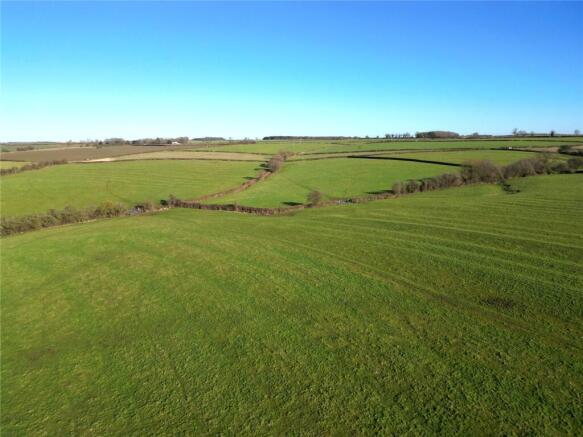
- 52 acres (21.05 hectares) of traditional grassland
- Classified Grade III
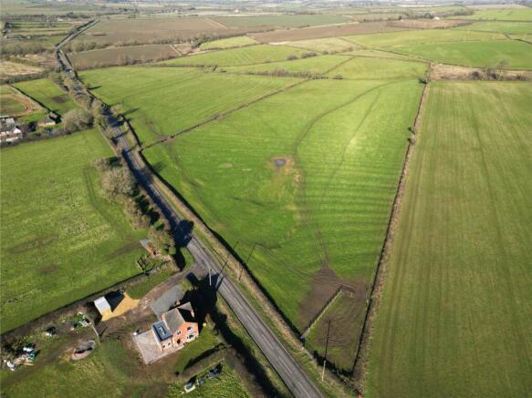
- Two Direct Road Access Points
- Freehold with Vacant Possession
- Ideal for Agricultural Grazing, Equestrian or Amenity Use
Description
Location
Waltham on the Wolds is nestled in the northeast corner of Leicestershire, approximately 5 miles from Melton Mowbray, 11 miles from Grantham, and 15 miles from Oakham. The village enjoys excellent connectivity, with Leicester, Nottingham, Newark, and Stamford all within 25 miles, and easy access to major road networks.
Dating back to its first mention in the Domesday Book of 1086, Waltham sits at an elevation of 560 feet, making it the second-highest village in Leicestershire and offering stunning views across the picturesque Vale of Belvoir.
This thriving community boasts a range of amenities, including a church, village hall, primary school, pub, shop/post office, first-class delicatessen, and a medical practice. It is further enriched by various local groups, such as the Scouts, Pre-School Club, Women’s Institute, and Neighbourhood Watch.
For commuters, Waltham is ideally located with convenient access to nearby towns and cities. Grantham’s mainline railway station is just a short drive away, offering a direct service to London King’s Cross in approximately 65 minutes. Additionally, Melton Mowbray’s railway station provides connections between Birmingham and Norwich.
Postcode – LE14 4AG
What3Words –The What3Words location for the gateway to the Land at Waltham is /// ///cattle.convinced.roadblock
The Land
The 52 acres (21.05 hectares) of Land is classified Grade III according to the Agricultural Land Classification Plans of England and Wales. The soil type is of the Ragdale Soil Association with fine loamy over clayey soils. The permanent pasture ridge and furrow grassland has previously been used for agricultural grazing, however with two direct roadside access points onto Goadby Road, lends itself to a range of Agricultural, equestrian and amenity uses, subject to the relevant permission(s).
Method of Sale
The Land is for sale by Private Treaty with a Guide Price of £425,000.
Services
The Land does not benefit from any mains services, both a water and electricity connection would be available in the vicinity. A water course crosses through the land and a collection water trough provides a drinking source for livestock.
Land Registry Title Number
LT519445
De-Linked Payments & Environmental Stewardship
The Vendor will retain all De-Linked Basic Payment Scheme payments associated with the Land from 2024 until the scheme concludes in 2027. The land is not part of any environmental schemes.
Development Uplift Clause
A Development Uplift Clause is applicable on the Land at a rate of 30% of the uplift in value of any development or renewable energy project over that of Agricultural or Equestrian, payable on the implementation of each and every Planning Permission(s) or sale of the land subject to Planning Permission(s) for period of 30 years.
Wayleaves, Easements & Rights of Way
An overhead Wayleave crosses the land from North to South. The Land is sold subject to and with the benefit of all rights, including Rights of Way whether public or private and all Easements and Wayleaves whether specifically mentioned or not.
Sporting, Timber & Mineral Rights
All Sporting and Timber Rights are included in the Freehold sale so far as they are owned. The mines and minerals together with ancillary powers of working are excepted with provision for compensation in the event of damage caused thereby.
Tenure & Possession
The Land is sold Freehold, and Vacant Possession will be given on Completion.
Viewing
At any reasonable time with these Sales Particulars in hand via prior appointment and permission to be given by Bentons.
Local Authority
Melton Borough Council Burton Street Melton Mowbray LE13 1GH Tel: Email:
Location
Waltham on the Wolds is nestled in the northeast corner of Leicestershire, approximately 5 miles from Melton Mowbray, 11 miles from Grantham, and 15 miles from Oakham. The village enjoys excellent connectivity, with Leicester, Nottingham, Newark, and Stamford all within 25 miles, and easy access to major road networks. Dating back to its first mention in the Domesday Book of 1086, Waltham sits at an elevation of 560 feet, making it the second-highest village in Leicestershire and offering stunning views across the picturesque Vale of Belvoir. This thriving community boasts a range of amenities, including a church, village hall, primary school, pub, shop/post office, first-class delicatessen, and a medical practice. It is further enriched by various local groups, such as the Scouts, Pre-School Club, Women’s Institute, and Neighbourhood Watch. For commuters, Waltham is ideally located with convenient access to nearby towns and cities. Grantham’s mainline railway station (truncated)
Extra Information
To check Internet and Mobile Availability please use the following link: checker.ofcom.org.uk/en-gb/broadband-coverage To check Flood Risk please use the following link: check-long-term-flood-risk.service.gov.uk/postcode
Brochures
ParticularsWaltham On The Wolds, Melton Mowbray

NEAREST STATIONS
Distances are straight line measurements from the centre of the postcode- Melton Mowbray Station5.0 miles
About Bentons, Melton Mowbray
47 Nottingham Street Melton Mowbray Leicestershire, LE13 1NN
Notes
Disclaimer - Property reference BNT250055. The information displayed about this property comprises a property advertisement. Rightmove.co.uk makes no warranty as to the accuracy or completeness of the advertisement or any linked or associated information, and Rightmove has no control over the content. This property advertisement does not constitute property particulars. The information is provided and maintained by Bentons, Melton Mowbray. Please contact the selling agent or developer directly to obtain any information which may be available under the terms of The Energy Performance of Buildings (Certificates and Inspections) (England and Wales) Regulations 2007 or the Home Report if in relation to a residential property in Scotland.
Map data ©OpenStreetMap contributors.