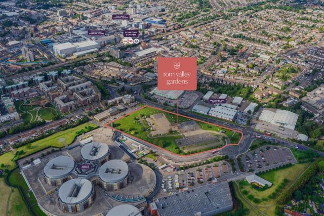
Land, Rom Valley Way, Romford, RM7 0AE

- SIZE AVAILABLE
305,791 sq ft
28,409 sq m
- SECTOR
Land for sale
Key features
- Planning permission for a hybrid phased mixed-use development scheme has been granted
- Freehold 7.02 acre development site
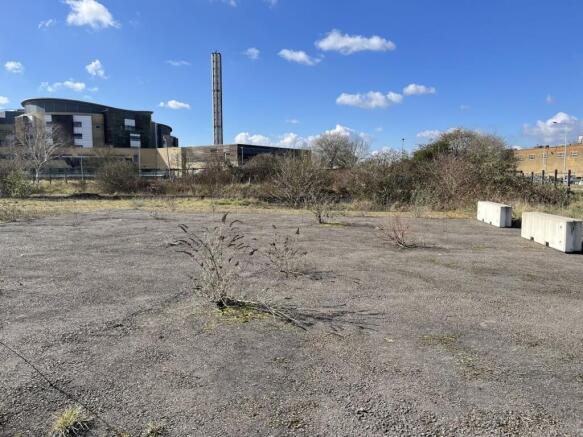
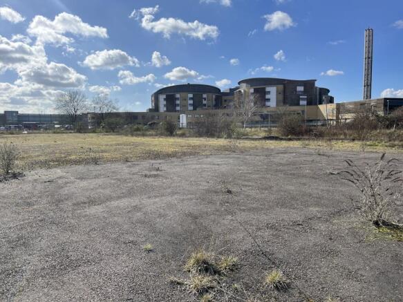
- Predominantly cleared site
- The surrounding area boasts a rich selection of retail, leisure, and green spaces
- Direct access via a roundabout from the A125
- 0.5 miles from Romford Station
Description
The site extends to approximately 7.02 acres (2.84 hectares) and occupies a strategic location between a large hospital complex, a local authority public car park, and the A125 Rom Valley Way. Historically, the site comprised undeveloped sand pits before becoming the home of the Romford Ice Rink in 1987, which remained in operation until its closure in 2013.
Today, the site is predominantly cleared, with a portion to the south used for parking and largely free from overgrowth. It benefits from direct access via a roundabout from the A125 Rom Valley Way, while a secondary access route through Old Church Road and Old Church Rise has been secured through a Deed of Easement, though it is yet to be constructed. Additionally, a third construction access from Rom Valley Way is being progressed in coordination with the Highways Department.
Location
The site is situated northwest of London’s Borough of Havering, in Romford, a designated metropolitan centre undergoing significant regeneration. Romford has evolved from its market town origins into a thriving civic and commercial hub, playing a key role in Greater London’s growth strategy. The area is exceptionally well-connected, positioned just 0.5 miles (a 9-minute walk) from Romford Station, offers direct links to Central London via National Rail services and the Elizabeth Line (Crossrail), ensuring efficient travel to key destinations such as Stratford (20 minutes), Liverpool Street (29 minutes), and beyond.
Romford also benefits from good road networks, with the A12, A13, and M25 providing convenient routes for drivers. Multiple bus services operate in the vicinity, with an interchange located just south of the site, further enhancing accessibility. Beyond transport links, the surrounding area boasts a rich selection of retail, leisure, and green spaces. Romford’s four major shopping centres—The Liberty, The Brewery, The Mercury, and Romford Shopping Hall—offer a wide variety of shops, restaurants, and entertainment options. Additionally, several parks, including Old Church Park and Raphael Park, provide open green spaces within walking distance.
Planning
The site has planning permission for a hybrid phased mixed-use development of seven blocks of 2-12 storeys to include up to 972 residential units comprising:
Block A: Full permission for 146 residential units, retail/restaurant unit, a medical or neighbourhood centre, an energy centre, and parking.
Blocks B to G: Outline permission for up to 826 residential units, alongside additional amenities and infrastructure.
Planning Reference: P0615.21(date 5th September 2023)
Brochures
Land, Rom Valley Way, Romford, RM7 0AE

NEAREST STATIONS
Distances are straight line measurements from the centre of the postcode- Romford Station0.4 miles
- Elm Park Station1.5 miles
- Dagenham East Station1.8 miles
Notes
Disclaimer - Property reference 290395-1. The information displayed about this property comprises a property advertisement. Rightmove.co.uk makes no warranty as to the accuracy or completeness of the advertisement or any linked or associated information, and Rightmove has no control over the content. This property advertisement does not constitute property particulars. The information is provided and maintained by Strettons, Commercial and Industrial Agency. Please contact the selling agent or developer directly to obtain any information which may be available under the terms of The Energy Performance of Buildings (Certificates and Inspections) (England and Wales) Regulations 2007 or the Home Report if in relation to a residential property in Scotland.
Map data ©OpenStreetMap contributors.