
West Anstey, South Molton

- PROPERTY TYPE
Land
- SIZE
2,881,930 sq ft
267,740 sq m
Key features
- Accessible Location
- 66.16 Acres (26.76 Hectares)
- Straw / Machinery Storage Building
- Poultry / Calf Rearing Buildings
- Pasture & Culm Grassland
- Deciduous Woodland
- Borehole Water & Mains Electricity Connected
- FREEHOLD
Description
Situation - Oaklands Farm is situated within the parish of West Anstey in North Devon with a fine outlook towards the Exmoor National Park and easily accessible from the towns of Dulverton, Tiverton and South Molton.
Dulverton lies 5.4 miles to the north-east and South Molton is 9.5 miles to the west. The larger market town of Tiverton lies 11 miles to the south-east from where the A361 dual carriageway links to the M5 at Junction 27.
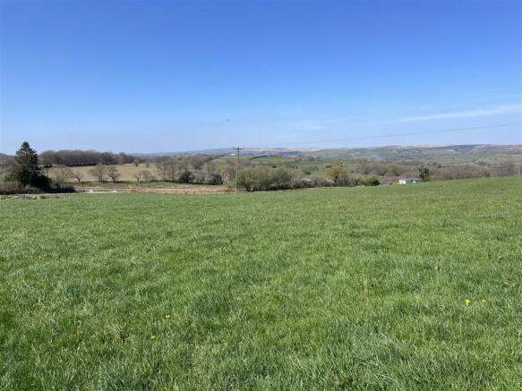
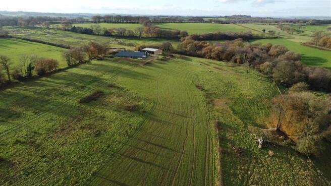
Description - Oaklands Farm extends to approximately 66.16 acres (26.76 hectares) and includes a versatile range of agricultural buildings which have been used for poultry and calf rearing. The land comprises a mixture of productive pasture fields for mowing and grazing together with some culm grassland for conservation and pockets of woodland.
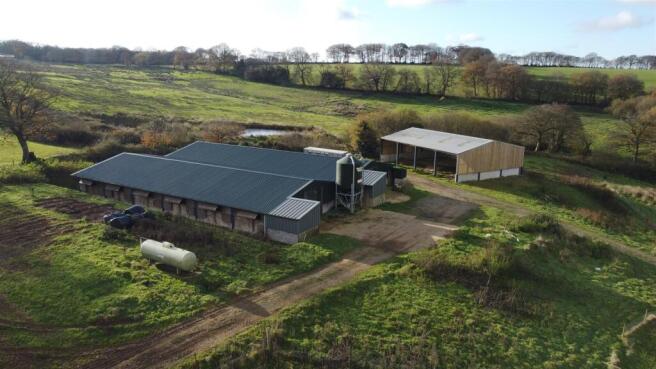
POULTRY / CALF REARING BUILDINGS: These buildings were originally constructed for the rearing of young poultry (capacity 7,000 birds) in 2017 and more recently have been used for calf rearing. Both buildings have a steel frame and box profile steel roof sheets and are insulated and part timber clad internally with a concrete floor.
Building 1: 27.43m x 13.72m plus a control room measuring 3.04m x 3.04m.
Building 2: 27.43m x 13.72m plus a control room measuring 3.04m x 3.04m.
STRAW / MACHINERY STORAGE BUILDING (17.91m x 13.13m). This building was constructed in 2021 with a steel frame and a fibre cement roof. It is open fronted and with concrete panels and timber space boarding above.
THE LAND: The land includes four grass enclosures which are suitable for mowing and grazing and are mostly gently sloping and there is an area of culm and purple moor grass known as Colliers Moor which has the River Yeo flowing along it's eastern boundary. In addition there are two areas of mature deciduous woodland which total approximately 5 acres.
Services - Private water from a borehole. Mains electricity is connected to the poultry / calf rearing buildings. There is also a spring and access to the River Yeo.
Access - There is direct access to the farm from the B3227 road.
Planning - Planning consent for the straw / machinery storage building was approved under reference 72255. Planning consent was approved for the agricultural building for rearing young poultry under reference 62753.
There is a planning enforcement notice for the removal of the mobile home which is currently on site and also the removal of the extension to the straw / machinery storage building.
Local Authority - North Devon District Council. Tel: . (
Land Management - The current owner has entered the farm into a Sustainable Farming Incentive (SFI) agreement.
Photographs - The photographs were taken in 2023 and 2025.
Designations - The farm is within a Nitrate Vulnerable Zone (NVZ) and a Less Favoured Area (LFA).
Sporting And Mineral Rights - The sporting and mineral rights insofar as they are owned are included with the freehold.
Wayleaves & Rights Of Way - The property is sold subject to and with the benefit of any wayleave agreement and any public or private rights of way that may affect it.
There are no public rights of way passing through the land.
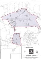
Boundary Plan - A plan which is not to scale, is included with these sale particulars for identification purposes only.
Viewing - All viewings are strictly by prior appointment with Stags. Please call or email: to arrange an appointment.
Directions - From Moortown Cross on the A361 (North Devon Link Road) proceed towards Knowstone. At the first crossroads continue straight across towards East Anstey, pass through the village of Roachill and continue on this road until reaching Blackerton Cross at the junction with the B3227.
Turn left towards South Molton, continue for approximately 750 yards and the farm will be found on the right, accessed via double metal gates.
What3words - Reference /// looms.raven.dozen
Disclaimer - These particulars are a guide only and are not to be relied upon for any purpose.
Brochures
West Anstey, South MoltonWest Anstey, South Molton

NEAREST STATIONS
Distances are straight line measurements from the centre of the postcode- King's Nympton Station12.9 miles


Notes
Disclaimer - Property reference 33823122. The information displayed about this property comprises a property advertisement. Rightmove.co.uk makes no warranty as to the accuracy or completeness of the advertisement or any linked or associated information, and Rightmove has no control over the content. This property advertisement does not constitute property particulars. The information is provided and maintained by Stags, Exeter. Please contact the selling agent or developer directly to obtain any information which may be available under the terms of The Energy Performance of Buildings (Certificates and Inspections) (England and Wales) Regulations 2007 or the Home Report if in relation to a residential property in Scotland.
Map data ©OpenStreetMap contributors.