
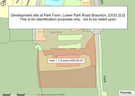
Lower Park Road, Braunton

- PROPERTY TYPE
Land
- SIZE
43,560 sq ft
4,047 sq m
Key features
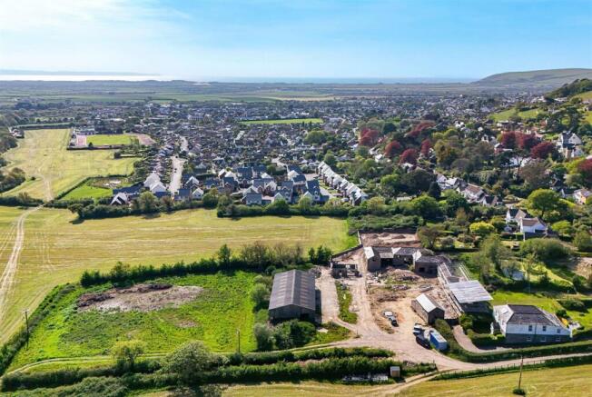
- Just over 1 acre site
- Consent for 3 houses
- One detached & Pair of semis
- Spacious Bedrooms
- Scope to revise consent
- Services on site
- Ample parking for each dwelling
- Large potential gardens
- Adjoins fields. Fine views
- Freehold
Description
Situation & Amenities - On the semi-rural outskirts of the village, enjoying fine views over open countryside and towards Heanton Church. We understand there will be estuary and sea views from the First Floors once the properties are built. The site is within a healthy walking distance of Braunton village, which offers a good range of local shopping facilities and amenities, providing for day-to-day needs, as well as a Tesco supermarket and both primary and secondary schools. The village is also ideally placed for easy access to the sandy surfing beaches at Croyde, Putsborough, Saunton (also with Championship Golf Course) and Woolacombe, which are approximately 5 miles to the West. Barnstaple the regional centre of North Devon is approximately 6 miles to the South East and houses the area’s main business, commercial, leisure and shopping venues. The town is well known for its exclusive range of outlets, including all of the High Street favourites, as well as a diverse selection of local stores. Other notable facilities include the Pannier Market, live theatre and North Devon District Hospital. Exmoor is within easy reach to the North East, and there is access at Barnstaple to the North Devon Link Road, leading through to Jct.27 of the M5, whilst Barnstaple Railhead supplies a link to the National Railway system, as well as to Exeter. London Paddington can be reached via Tiverton Parkway in just over 2 hours. The nearest international airports are at Bristol and Exeter. There is a good choice of private schools in the general area including West Buckland, Kingsley at Bideford and Blundell’s at Tiverton.
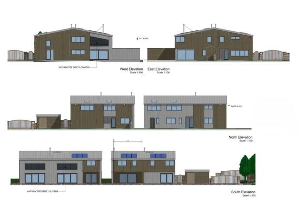
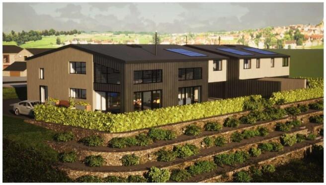
Description & Planning Permission - This freehold site has consent to build three 2-storey properties. These include a detached 4-bedroom house and a pair of semi-detached houses - one 3 bedrooms and the other 2. Subject to a change in planning permission it may be possible to apply for a different configuration of accommodation, with potential for one much larger house or two detached, subject to a buyer’s requirements.
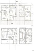
Please see the attached plans for more layout information.
Planning permission was granted by North Devon Council, under Planning Reference 76333 in September 2023 for ‘demolition of barns, erection of three dwellings and associated works (following Class Q approval 66392 for the change of use and conversion of the barn to five dwellings) (amended description)’. The latest consent is subject to a Section 106 Agreement, where the developer will be required to make a payment of £8,606.00.
Services - Mains water is connected. Electricity is due for connection in June (3x3 phase connections). The plans assume that the properties will drain into their own new treatment plant, which is anticipated to sit on the West side of the site, with clean water draining into a stream in the ownership of the site. The initial access track is owned by a third party, but purchasers will have full rights over it. The owner has a duty to maintain it to a standard, private cars and pedestrians can reasonably use it but not obstruct it.
Directions - On leaving the traffic lights at the centre of the village of Braunton, proceed in the direction of Barnstaple, then turn immediately left into Heanton Street. At the end of Heanton Street, bear left and within a short distance at the mini roundabout bear right into Lower Park Road. Continue for approximately ½ mile and just before you leave the village, pass Park Farmhouse on your right and take the access immediately afterwards which is Park Farm. Continue onto the site and the building plots are to your left, where there is currently a modern barn in place. Alternatively, leaving Barnstaple through Pilton and Bradiford, climb the hill towards Prixford and bear 1st left signed Ashford and Heanton. Follow this lane through open countryside to Braunton, and the access to the site will be found on the left-hand side as the first lane, having left open countryside.
Special Note - Opposite the site is a range of period barns, currently being converted to private residences. When viewing please be aware that you are entering an active building site. Appropriate footwear should be used and care taken.
Brochures
Development Site at Park Farm Brochure.pdfLower Park Road, Braunton

NEAREST STATIONS
Distances are straight line measurements from the centre of the postcode- Barnstaple Station4.3 miles


Notes
Disclaimer - Property reference 33850424. The information displayed about this property comprises a property advertisement. Rightmove.co.uk makes no warranty as to the accuracy or completeness of the advertisement or any linked or associated information, and Rightmove has no control over the content. This property advertisement does not constitute property particulars. The information is provided and maintained by Stags, Barnstaple. Please contact the selling agent or developer directly to obtain any information which may be available under the terms of The Energy Performance of Buildings (Certificates and Inspections) (England and Wales) Regulations 2007 or the Home Report if in relation to a residential property in Scotland.
Map data ©OpenStreetMap contributors.