
Bottom House, Wreay, Carlisle, Cumbria
- PROPERTY TYPE
Detached
- SIZE
Ask agent
- TENUREDescribes how you own a property. There are different types of tenure - freehold, leasehold, and commonhold.Read more about tenure in our glossary page.
Ask agent
Description
DESCRIPTION
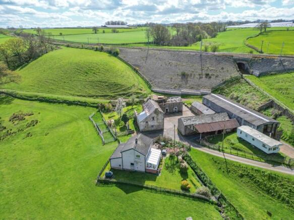
A rare opportunity to purchase a smallholding with renovation potential.
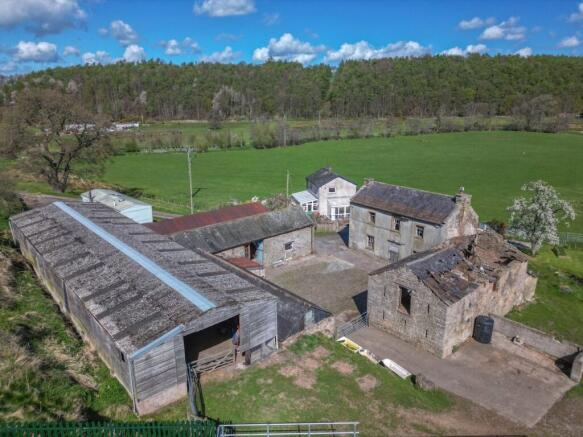
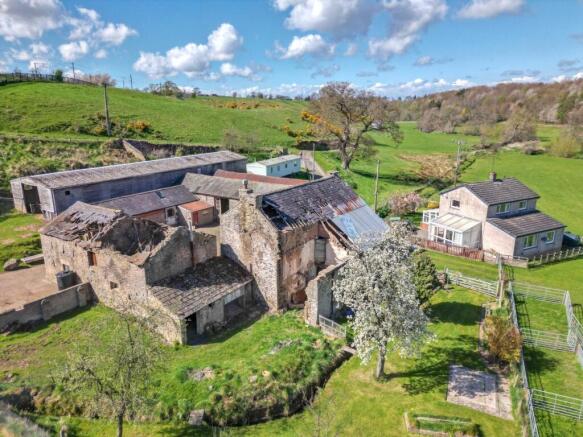
Bottom House is set within 5 acres (2.02 Hectares) with two parcels of good quality grazing land together with a 3 bedroomed farmhouse, renovation potential property and a range of traditional and semi-modern outbuildings set within a cobbled courtyard. Bottom House comprises a 3-bedroom brick-built property with a concrete tile roof which benefits from a double-glazed conservatory as well as an adjoining sunroom. On site there is the former farmhouse and several outbuildings with conversion potential, subject to relevant consents, including the former stables, hay barn as well as an extensive storage shed.
LOCATION
Bottom House is located less than 1 mile South East of Wreay with excellent transport links to the A6 and M6.
What 3 Words: graphics.ballooned.outwit
DIRECTIONS
Exit the M6 at Junction 42 and follow the A6. Follow the A6 for 2.3 miles and then turn right signposted for Wreay. Follow this road for 0.8 miles and take the first left, then turn right over the bridge then left over the cattle grid. Bottom House is situated at the end of the hardcore track.
LOCAL AMENITIES
Bottom House Farm is located close to the small village of Wreay which benefits from Wreay Church of England Primary School, together with a public house, church and village hall.
BOTTOM HOUSE
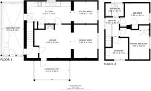
GROUND FLOOR:
Conservatory 6.56m x 2.76m
Kitchen 2.77m x 5.55m
Sitting Room 2.96m x 2.77m
Dining Room 2.96m x 4.18m
Lounge 4.59m x 4.18m
Conservatory 4.31m x 2.39m
Hallway
FIRST FLOOR:
Bathroom 2.30m x 1.64m
Hallway
Bedroom 3.66m x 2.74m
Bedroom 3.66m x 3.68m
Bedroom 2.84m x 2.71m
A traditional cobbled courtyard leads to an area of concrete to the rear of the derelict property which is used to access the land.
OUTBUILDINGS
Derelict House 12.08 x 12.14m
Pebble dash rendered stone with slate roof.
Former Stables - 5.79m x 5.20m & 5.70m x 5.20m. Traditional stone building with slate roof covering divided into two former stables.
Adjoining lean to which is also stone constructed with slate roof.
Current Stables 9.14m x 30.48m
Original stone construction which has later been heightened with brick, stone floor, tin sheet covering over gable end and slate roof covering.
Adjoining outbuilding - 2.30m x 3.35m Block construction with tin sheet roof.
Former Hay Barn - 11.50m x 4.35m Stone with slate roof covering, stone floor and exposed wooden beams.
Stable 4.50m x 4.57m Stone construction with slate roof covering and exposed wooden beams. General Purpose Building 8.56m x 30.22m
Timber frame, wooden cladding with corrugated cement roof.
Carport
Static Caravan
Mains electricity and water with domestic drainage to a septic tank.
LAND
The land included with the property extends in total to 4.38 Acres (1.77 Hectares) which comprises of a mixture of permanent pasture, grazing and amenity land with a steady incline.
Stock proof boundaries comprise of post and wire fences.
NITRATE VULNERABLE ZONE
The land is situated within an NVZ.
ENVIRONMENTAL SCHEMES
The land is not entered into any schemes.
COUNCIL TAX
Band C.
SERVICES
Oil powered central heating with mains electric and metered private water being connected. Neither these services nor any boilers or radiators have been tested. Drainage is to a septic tank. Any alterations required to meet current regulations are to be the responsibility of the purchaser.
Please note no formal investigation has been carried out as to the operation of the sewerage system and septic tanks, these may not meet the current General Binding Rules 2020, and the property is being sold on this basis. All parties must ensure that their lenders are aware of this before submitting an offer.
ACCESS
The property is accessed via a right of way over the hardcore track. The maintenance of this is shared between Bottom House, the neighbouring property and the owner of the adjoining land.
VIEWINGS
The property is available to view by prior appointment with the Carlisle office of H&H Land and Estates, .
CONTACT
Janet Flintoft – Janet.
Alice Fawcett – Alice.
MATERIAL INFORMATION
We understand that broadband and mobile telephone reception are available. For an indication of speeds and supply please see the OFCOM website:
TENURE
Freehold.
Brochures
Particulars- COUNCIL TAXA payment made to your local authority in order to pay for local services like schools, libraries, and refuse collection. The amount you pay depends on the value of the property.Read more about council Tax in our glossary page.
- Band: C
- PARKINGDetails of how and where vehicles can be parked, and any associated costs.Read more about parking in our glossary page.
- Yes
- GARDENA property has access to an outdoor space, which could be private or shared.
- Ask agent
- ACCESSIBILITYHow a property has been adapted to meet the needs of vulnerable or disabled individuals.Read more about accessibility in our glossary page.
- Ask agent
Bottom House, Wreay, Carlisle, Cumbria

Add an important place to see how long it'd take to get there from our property listings.
__mins driving to your place
Get an instant, personalised result:
- Show sellers you’re serious
- Secure viewings faster with agents
- No impact on your credit score

About H&H Land & Estates, Carlisle
Borderway Mart, Rosehill, Carlisle, Cumbria, CA1 2RS

Your mortgage
Notes
Staying secure when looking for property
Ensure you're up to date with our latest advice on how to avoid fraud or scams when looking for property online.
Visit our security centre to find out moreDisclaimer - Property reference CLE250015. The information displayed about this property comprises a property advertisement. Rightmove.co.uk makes no warranty as to the accuracy or completeness of the advertisement or any linked or associated information, and Rightmove has no control over the content. This property advertisement does not constitute property particulars. The information is provided and maintained by H&H Land & Estates, Carlisle. Please contact the selling agent or developer directly to obtain any information which may be available under the terms of The Energy Performance of Buildings (Certificates and Inspections) (England and Wales) Regulations 2007 or the Home Report if in relation to a residential property in Scotland.
*This is the average speed from the provider with the fastest broadband package available at this postcode. The average speed displayed is based on the download speeds of at least 50% of customers at peak time (8pm to 10pm). Fibre/cable services at the postcode are subject to availability and may differ between properties within a postcode. Speeds can be affected by a range of technical and environmental factors. The speed at the property may be lower than that listed above. You can check the estimated speed and confirm availability to a property prior to purchasing on the broadband provider's website. Providers may increase charges. The information is provided and maintained by Decision Technologies Limited. **This is indicative only and based on a 2-person household with multiple devices and simultaneous usage. Broadband performance is affected by multiple factors including number of occupants and devices, simultaneous usage, router range etc. For more information speak to your broadband provider.
Map data ©OpenStreetMap contributors.