Washdike Lane, Halton Holegate, Spilsby
- PROPERTY TYPE
Land
- SIZE
Ask agent
Key features
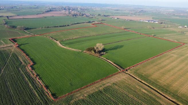
- 40.00 Acres of Arable and Pasture Land
- Washdike Lane, Halton Holegate, Nr. Spilsby, Lincolnshire
- Offers in excess of: £325,000
Description
The land has been well farmed and is currently let on a licence terminating on the 30th September 2025.
(Should you not wish to purchase the permanent pasture land, please contact the agent to discuss the possibility).
(A further 7.14 acres on the opposite side of the road is currently being marketed for sale, please contact the agent for more details.)
For Sale by Private Treaty
Offers in excess of: £325,000
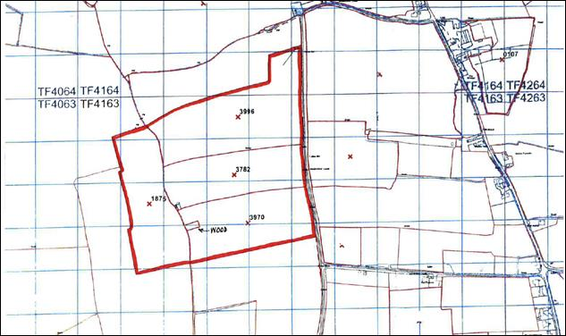
Description - The land has direct access onto Washdike Lane and comprises three enclosures of productive arable land (26.66 acres), one enclosure of permanent pasture (13.10 acres) and small spinney.
What3Words: accented.reports.swim.
Tenure & Possession - The land is Freehold and is being sold with Vacant Possession from the 30th September 2025.
Grade, Soil Type & Topography - All the land is scheduled as Grade 3 by the Agricultural Land Classification of England and Wales.
The soil type as defined by the Soil Survey of England and Wales as predominately
Salop – Slowly permeable seasonally waterlogged reddish fine loamy over clayey, fine loamy and clayey soils associated with fine loamy over clayey soils with slowly permeable subsoils and slightly seasonal waterlogging.
The land is level lying.
Rural Payments Agency - All of the land is registered with the Rural Payments Agency, however, there are no Basic Payment Scheme Entitlements included in the sale as they are no longer transferable.
Stewardship & Sustainable Farming Incentive Scheme - None of the land is currently entered into any Stewardship or SFI schemes.
Underdrainage - Part of the land has been comprehensively underdrained (contact agent for a copy of the plans).
Boundaries - The land is clearly demarcated by boundary features, being predominantly hedges and ditches. The vendor will, to the best of their knowledge specific the ownership of boundaries upon request but neither the vendor nor the selling agent will be responsible for the information provided and the purchaser is deemed to have full knowledge.
Services - There is a mains water supply connected to water troughs in the pastureland.
Outgoings & Nitrogen Vulnerable Zones - Annual drainage rates for the majority of the land are payable to Witham Fourth District Internal Drainage Board (approx £12.80 per acre for 2024/25 season). The land lies within a Surface Water Nitrate Vulnerable Zone.
Hm Land Registry - The land is not registered with HM Land Registry.
Sporting, Timber & Mineral Rights - Sporting, timber and mineral rights are included in the sale insofar as they are owned, subject to statutory exclusions.
Easements, Wayleaves & Rights Of Way - The north western corner of Field No. 1875 is crossed by a public footpath.
We are not aware of any other rights which affect the land; however, all of the land is sold subject to and with the help and benefit of all existing rights, including rights of way whether public or private, light, support, drainage, water and electricity supplies and other rights, easements and all wayleaves whether referred to or not in these particulars.
Plans, Areas & Schedules - These have been prepared as accurately as possible and are based on the Ordnance Survey Plans and the Rural Land Register maps and although believed to be correct are for guidance and identification purposes only.
Viewing - The land may be viewed at any reasonable time during daylight hours providing a set of these particulars are to hand. When viewing, interested parties are responsible for their own safety and view at their own risk. Important Notice: Part of the land is grazed by livestock, therefore please take extreme care when viewing and there must be no dogs or children present.
Vat - It is understood that the sale will not attract VAT, however, in the event that any of the property is sold subject to VAT, this will be payable in addition to the purchase price.
Anti Money Laundering - In accordance with the most recent Anti Money Laundering legislation the purchaser will be required to provide proof of identity and proof of funds to the selling agent once an offer has been submitted and accepted (subject to contract) prior to solicitors being instructed.
Local Authorities - Lincolnshire County Council, County Offices, Newland, Lincoln LN1 1YL
Tel:
East Lindsey District Council, The Hub, Mareham Road, Horncastle LN9 6PH
Tel:
Witham Fourth District Internal Drainage Board, 47 Norfolk Street, Boston, Lincolnshire PE21 6PP – Tel:
Environment Agency, Ceres House, Searby Road, Lincoln LN2 4DW
Tel:
Contact And Offers - Should you wish to discuss any detail regarding this land or wish to make an offer please contact Lizzie Clarke on .
Anti Money Laundering - In accordance with the most recent Anti Money Laundering legislation the purchaser will be required to provide proof of identity and proof of funds to the selling agent once an offer has been submitted and accepted (subject to contract) prior to solicitors being instructed.
Brochures
40.00 Acres of Arable Land - Halton Holegate.pdfBrochureWashdike Lane, Halton Holegate, Spilsby

NEAREST STATIONS
Distances are straight line measurements from the centre of the postcode- Thorpe Culvert Station4.0 miles

Notes
Disclaimer - Property reference 33873109. The information displayed about this property comprises a property advertisement. Rightmove.co.uk makes no warranty as to the accuracy or completeness of the advertisement or any linked or associated information, and Rightmove has no control over the content. This property advertisement does not constitute property particulars. The information is provided and maintained by Willsons, Skegness. Please contact the selling agent or developer directly to obtain any information which may be available under the terms of The Energy Performance of Buildings (Certificates and Inspections) (England and Wales) Regulations 2007 or the Home Report if in relation to a residential property in Scotland.
Map data ©OpenStreetMap contributors.