Land At Station Road, Bluntisham, Cambridgeshire, PE28 3PA
£0.21 per sq ft
Business rates & charges may apply

- SIZE AVAILABLE
1,094,663 sq ft
101,698 sq m
- SECTOR
Farm land for sale
Key features
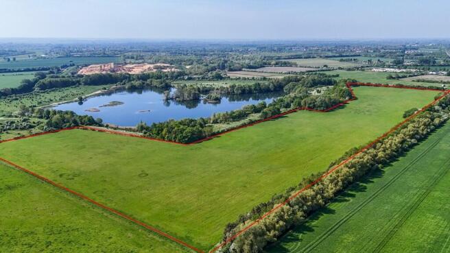
- Approximately 25.13 acres (10.169 hectares)
- Direct access onto Station Road A1123.
- Grade 2 and 3 grassland
Description
Direct access onto Station Road A1123.
Grade 2 and 3 grassland
Land at Station Road, Bluntisham
In all approximately 25.13 acres (10.169 hectares) | Available as a whole
FOR SALE BY PRIVATE TREATY
Detailed Description
THE PROPERTY
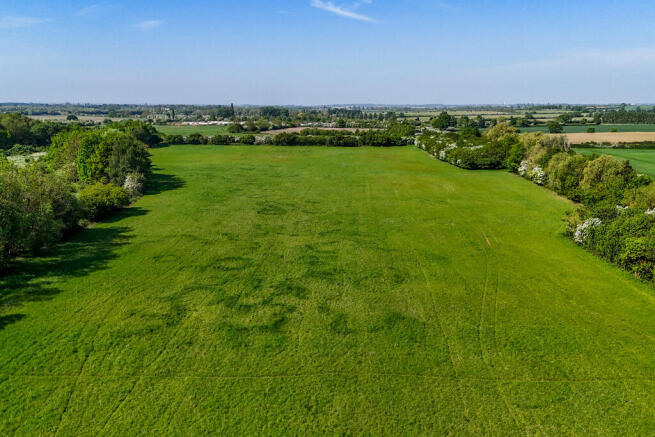
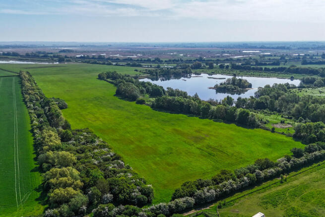
The property comprises approximately 25.13 acres (10.169 hectares) of pastureland, benefitting from access off Station Road - A1123.
The land is Grade 3 land, the soil type is a mixture of Evesham 3, which is described as slowly permeable calcareous clayey and fine loamy over clayey soils, and Midelney, which is described as a stoneless clayey soil mostly overlying peat. The majority of the land is in Flood Zone 2, with the areas near water courses being within Flood Zone 3. The land is currently mown for silage.
There are small pockets of woodland which are areas of former orchard. The land is well defined with clear boundaries on 3 sides with the southern and eastern boundaries bordering the RSPB Ouse Fen Nature Reserve.
LOCATION AND SITUATION
The land is situated 1 mile to the south of the Cambridgeshire Village of Bluntisham, 3.5 miles east of St Ives and 10 miles east of
Huntingdon.
Nearest Postcode: PE28 3PA
what3words: ///tenure.fantastic.floating
ACCESS
The property benefits from direct access onto Station Road A1123.
GENERAL REMARKS AND STIPULATIONS
Method of Sale
The property is offered for sale as a whole by Private Treaty.
Tenure
The freehold of the land is being sold subject to Vacant Possession.
Land Drainage
We are not aware of any historic land drainage schemes.
Statutory Designations
The property is within surface and ground water Nitrate Vulnerable Zones (NVZ).
Public Rights of Way
There are no Public Rights of Way crossing the land.
Services
There are no services connected to the land.
Wayleaves, Easements & Rights Of Way
The property is being sold subject to and with the benefit of all rights including rights of way whether public or private, light,
sport, drainage, water and electricity suppliers and other rights obligations, easements and quasi-easements and restrictive covenants and all existing and proposed wayleaves for masts, pylons, stays, cables, drains, water and gas or other pipes whether referred to in these particulars or not.
Land Registry
The property is registered under Land Registry Title CB153912.
Drainage Rates
The land is situated within the Bluntisham Internal Drainage Board area with rates payable at the prevailing rate.
Sporting Rights
The sporting rights are included in the sale of the property so far as they are owned.
Timber & Minerals
The Timber Rights are included in the sale of the property so far as they are owned.
The Mineral Rights in the area coloured blue on the plan are included in the sale. The Mineral rights in the area coloured pink in the plan are excluded from the sale, these being owned by previous owners.
Disputes
Should any disputes arise as to the boundaries or any matters relating to these particulars, or the interpretation thereof, that matter will be referred to an arbitrator to be appointed by the selling agent.
Plans, Red Lines & Areas
These are prepared as carefully as possible by referenced additional OS data and the Rural Land Register. The plans and red lines are published for illustrative purposes only and although they are believed to be a correct their accuracy cannot be guaranteed.
Anti-Money Laundering
In accordance with the most recent anti money laundering legislation the purchaser will be required to provide proof of identity and address to the selling agent once an offer has been submitted and accepted (subject to contract) prior to solicitors being instructed.
Boundaries
The buyer(s) shall deem to have full knowledge of all boundaries and neither the seller nor the selling agents will be responsible for defining boundaries nor their ownership.
Value Added Tax (VAT)
Should any sale of the land or any rights attached become a chargeable supply for the purposes of VAT, such tax will be payable by the buyers in addition to the contract price.
Local Authority
Huntingdonshire District Council, Pathfinder House, St Mary's Street,
Huntingdon, PE29 3TN
Health & Safety
Given the potential hazards we would ask you be as vigilant as possible when making your inspection of the property for your own personal safety.
Viewing
The Property may be viewed at any time with a copy of these particulars to hand, subject to prior notification to the Vendor's
Agent. Viewing is at your own risk and neither the Vendor's Agent nor Vendor take any responsibility for any losses or damages incurred during inspection.
Brochures
Land At Station Road, Bluntisham, Cambridgeshire, PE28 3PA

NEAREST STATIONS
Distances are straight line measurements from the centre of the postcode- Huntingdon Station8.4 miles
About Brown & Co, St. Neots
The Fairways, Wyboston Lakes, Great North Road Wyboston St. Neots MK44 3ALNotes
Disclaimer - Property reference 447093FH. The information displayed about this property comprises a property advertisement. Rightmove.co.uk makes no warranty as to the accuracy or completeness of the advertisement or any linked or associated information, and Rightmove has no control over the content. This property advertisement does not constitute property particulars. The information is provided and maintained by Brown & Co, St. Neots. Please contact the selling agent or developer directly to obtain any information which may be available under the terms of The Energy Performance of Buildings (Certificates and Inspections) (England and Wales) Regulations 2007 or the Home Report if in relation to a residential property in Scotland.
Map data ©OpenStreetMap contributors.