
Clopton, Nr Woodbridge
- PROPERTY TYPE
Land
- SIZE
2,962,080 sq ft
275,186 sq m
Description
Introduction
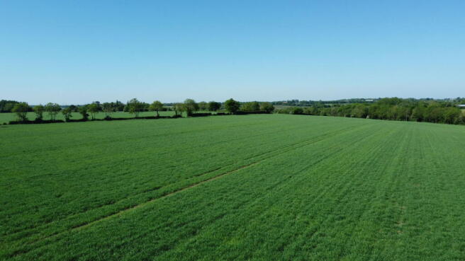
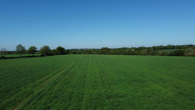
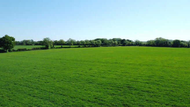
The land at Clopton extends to approximately 68 acres (27.52 hectares) and comprises a ring fenced block of arable land near Woodbridge.
Method of Sale
We are instructed to offer the land by private treaty inviting offers for the whole with the intention of achieving exchange of contracts as soon as possible with completion four weeks thereafter.
It is expected that the purchaser will be required to sign an ‘Exclusivity Agreement’ with a 5% ‘Exclusivity Fee’ being paid to and held by the Vendor’s solicitor. A draft ‘Exclusivity Agreement’ is available from the Agent.
Vendor’s Solicitor
Barker Gotelee. 41 Barrack Square, Martlesham Heath, Ipswich, Suffolk, IP5 3RF Tel: Contact: Miles Coates. Email: miles.
Location
The land is located in a pleasant rural location on the outskirts of the popular village of Clopton. It is well placed for easy access to Ipswich (seven miles), Woodbridge (six miles) and Framlingham (eight miles). The neighbouring village of Otley has a well regarding Post Office/village shop, a doctors surgery, primary school, village hall and excellent pub. Trains to London’s Liverpool Street Station can be found at Ipswich. The coast, with popular destinations such as Aldeburgh, Thorpeness and Southwold, is just 18 miles to the east.
Description
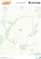
This block of land provides the purchaser with an opportunity to acquire a ring fenced block of productive land extending in all to 68 acres (27.52 hectares). The land is shown outlined red on the enclosed plan.
The land comprises three good sized arable fields and the field boundaries are well defined by ditches, mature trees and hedgerows. The land slopes in topography from north to south and there is good access into the property off Manor Road. From here, there are internal gateways into each field. The soil type is classified as Grade 3 under the DEFRA 1:250,000 Land Classification Map, being productive loam and clay soil ideally suited to arable rotation. The land has typically been farmed in a white straw rotation of winter wheat, oil seed and beans. The current cropping is spring barley.
Rights of Way, Wayleaves and Easements
The property is sold subject to and with the benefit of all rights of way, wayleaves and easements that may affect the land. There are two public footpaths crossing the property.
Timber, Sporting and Minerals
All sporting rights, standing timber and mineral rights (except reserved by Statute or to the Crown) are included in the sale of the freehold.
Environmental Stewardship Scheme
The land is not included within an Environment Stewardship Scheme.
Boundaries
The vendor shall not be required to define the boundaries on the ground. These are shown for identification purposes only outlined red on the enclosed plan. Purchasers should satisfy themselves with regard to these and no error, omission or misstatement will allow the purchaser to rescind the contract nor entitle either party to compensation thereof. The property is registered with the Land Registry under Title Number SK277091.
Town and Country Planning
The property is sold subject to any development plans, tree preservation orders, ancient monument orders and Town and Country schedules or other similar matters that may be or come into force.
Outgoings & VAT
The land is sold subject to any drainage rates and other outgoings that may be relevant. Should any sale of the land, or any right attached to it, become a chargeable supplier for the purpose of VAT, such VAT shall be payable by the purchaser in addition to the contract price.
Tenure and Possession
The land is sold freehold with vacant possession, subject to the existing Cropping Licence. Notice has been served, to terminate the licence on 30th September 2026. The licence fee will be apportioned upon completion.
Quotas and Basic Payment Scheme
No Entitlements nor any quotas or contracts shall be sold with the land.
Information Pack
An ‘Information Pack’, containing details relating to cropping, land drainage, the Title etc., is available for inspection at the Agent’s office or can be emailed to interested parties.
Brochures
Brochure 1Clopton, Nr Woodbridge

NEAREST STATIONS
Distances are straight line measurements from the centre of the postcode- Melton Station4.7 miles
- Woodbridge Station4.8 miles
- Westerfield Station5.7 miles


Notes
Disclaimer - Property reference S1310434. The information displayed about this property comprises a property advertisement. Rightmove.co.uk makes no warranty as to the accuracy or completeness of the advertisement or any linked or associated information, and Rightmove has no control over the content. This property advertisement does not constitute property particulars. The information is provided and maintained by Clarke and Simpson, Framlingham. Please contact the selling agent or developer directly to obtain any information which may be available under the terms of The Energy Performance of Buildings (Certificates and Inspections) (England and Wales) Regulations 2007 or the Home Report if in relation to a residential property in Scotland.
Map data ©OpenStreetMap contributors.