Fernises Farm, OL10
- PROPERTY TYPE
Farm
- BEDROOMS
3
- SIZE
1,332 sq ft
124 sq m
Key features
- Sought after edge of settlement location
- A brick built two storey three bedroom dwelling
- An extensive range of modern and traditional buildings
- Immediate development potential through the conversion of some of the modern and traditional buildings (STPP)
- Land area extending to approximately 48.75acres or thereabouts
- For sale by private treaty as a whole
Description
LOCATION
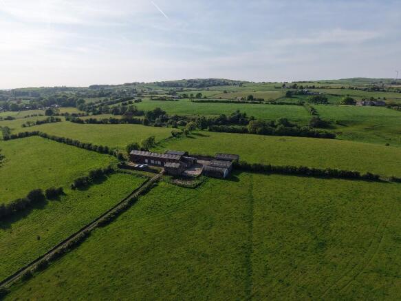
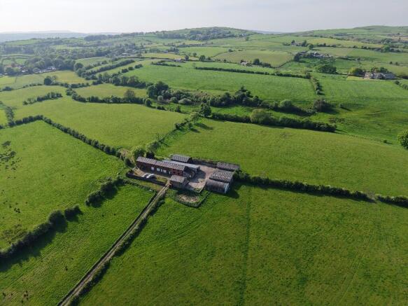
Fernises Farm sits in a rural area between the towns of Bury and Rochdale in the parish of Birtle with Bamford and it is located approximately 4 miles from Rochdale Town Centre and 3.5 miles from Bury Town Centre. There is easy access to the M66 and the M62 and to the wider motorway network. There are a wide range of services and amenities within close proximity to the property.
DESCRIPTION
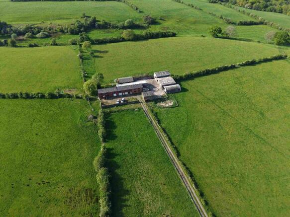
Fernises Farm comprises a two storey brick built dwelling, a range of two storey height brick built farm buildings, a traditional two storey height stone built barn and a range of modern farm buildings, which were last used to accommodate a herd of dairy cattle and approximately 48.75acres of grassland. The farmstead and access road occupy an area extending to approximately 1.18acres or thereabouts.
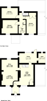
Farmhouse:
The farmhouse provides accommodation over two floors.
The ground floor comprises an entrance hall, sitting room, lounge, dining room, kitchen and larder.
The first floor comprises three bedrooms a bathroom and an airing cupboard.
The gross internal floor area of the farmhouse is 124m² (1,332ft²).
The dwelling and adjoining buildings sit in an elevated position with panoramic long distance south facing views from the front elevation.
The Buildings:
There is range of both modern and traditional farm buildings at Fernises Farm all of which are well maintained and in good condition. The farmhouse adjoins a two storey height traditional brick built range of buildings, which in turn adjoin a number of modern farm buildings. There is also a detached two storey height stone built barn and a separate group of three modern farm buildings. A schedule of the buildings providing their size and past use is attached.
The Land:
Excluding the yard area and access lane, which extend to approximately 1.18acres, the land, which is all down to grass, extends to approximately 48.75 acres or there-abouts. A schedule of the areas of the various land parcels is included.
SERVICES
The property has the benefit of mains gas, electric and water. The farm also has a borehole water supply. Foul drainage is by means of a private septic tank which is assumed not to be compliant with the latest building regulations and the buyer must make their offer accordingly.
TENURE
Freehold with Vacant Possession on completion.
PLANNING
The adopted local plan for Rochdale supports the conversion of traditional farm buildings into alternative uses either commercial or residential subject to certain criteria being satis-fied. In respect of the traditional buildings at Fernises Farm we consider that they satisfy the criteria and are suitable for conversion to residential use, this would be the brick range and the detached stone building.
Nationally the Government in recent years created a new category of permitted develop-ment known as Class Q which allows the conversion of modern farm buildings into dwellings subject to qualifying criteria, and we consider that there is also scope under these provisions to convert some of the modern farm buildings at Fernises Farm into dwellings.
Our assessment is that, subject to the necessary planning approvals, there is scope to create up to five additional dwellings from the buildings at the farm which could provide circa 550m² (5,900ft²) of living accommodation.
COUNCIL TAX
The dwelling is in Band D.
VIEWING
Strictly through the selling agents Gary Hoerty Associates, by appointment only.
PLANS AND AREAS
The plans in these particulars are a copy of the Ordnance Survey data from Promap. All plans are for identification purposes only and areas are approximate and subject to verification in the title documents.
METHOD OF SALE
The property is offered for sale by private treaty.
WAYLEAVES, EASEMENTS AND RIGHTS OF WAY
There are three footpaths crossing the property.
LOCAL AUTHORITY
Rochdale Metropolitan Borough Council, Council Offices, Smith Street, Rochdale, OL16 1XU
FLOODING
According to the Environment Agency website, the property sits in flood zone 1.
MONEY LAUNDERING REGULATIONS
Prospective buyers should be aware that in the event they submit an offer on the prop-erty it is required that they provide documents in relation to money laundering regula-tions. These must be in the form of confirmation of the purchasers ability to fund the purchase, photographic identification (i.e. driving licence or passport) and a utility bill showing the potential purchaser's address, these can be provided in the following ways:
* Bring original documents to copy into Gary Hoerty Associates Ltd office.
* Post original documents to copy by Gary Hoerty Associates Ltd
* Post a certified copy via your solicitor.
Brochures
Brochure 1Energy Performance Certificates
EPC 1Fernises Farm, OL10

NEAREST STATIONS
Distances are straight line measurements from the centre of the postcode- Castleton Station2.8 miles
- Bury Station2.7 miles
- Bury Interchange Tram Stop2.7 miles
About GHA Associates, Grindleton
Suite 9 Grindleton Business Centre, The Spinney, Grindleton, Clitheroe BB7 4DHNotes
Disclaimer - Property reference FernisesFarm1. The information displayed about this property comprises a property advertisement. Rightmove.co.uk makes no warranty as to the accuracy or completeness of the advertisement or any linked or associated information, and Rightmove has no control over the content. This property advertisement does not constitute property particulars. The information is provided and maintained by GHA Associates, Grindleton. Please contact the selling agent or developer directly to obtain any information which may be available under the terms of The Energy Performance of Buildings (Certificates and Inspections) (England and Wales) Regulations 2007 or the Home Report if in relation to a residential property in Scotland.