Grangemoor Road, Widdrington Station, Widdrington, NE61
£7.27 per sq ft
Business rates & charges may apply

- SIZE AVAILABLE
1,651 sq ft
153 sq m
- SECTOR
Shop to lease
Lease details
- Lease available date:
- Ask agent
Key features
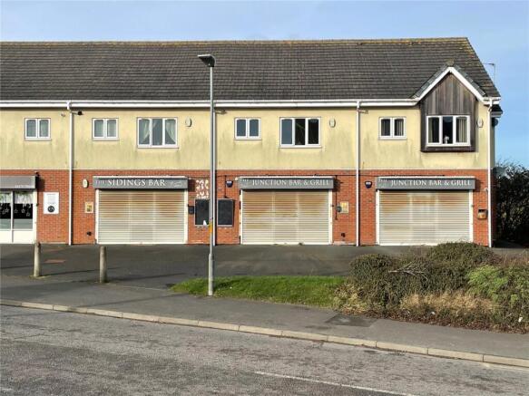
- Ground floor retail unit
- Former bar/restaurant
- Attractive roadside location
- Close to railway station
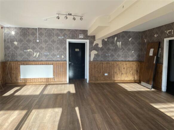
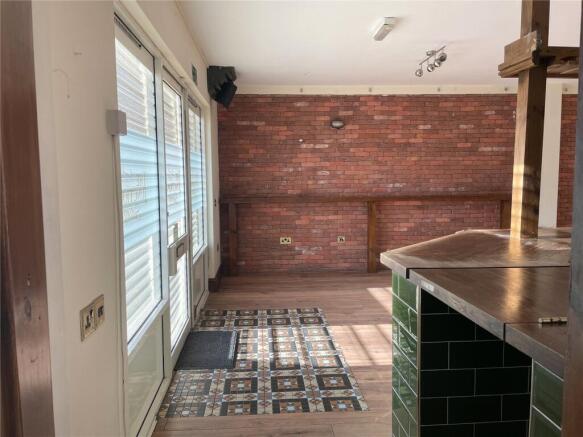
Description
DESCRIPTION
Ground floor retail unit last used as a bar and restaurant.
ACCOMMODATION
The property includes the following gross internal areas:
Ground Floor Restaurant 138.7 sq m / 1,493 sq ft
Ground Floor Staff Toilets 4.45 sq m / 48 sq ft
Ground Floor Internal Storage 4.25 sq m / 46 sq ft
Ground Floor Internal Storage 3.41 sq m / 36 sq ft
Total 150.81 sq m / 1,623 sq ft
TERMS
The premises are available via a new effective full repairing and insuring lease on terms to be agreed at a rental of £12,000 per annum.
RATING ASSESSMENT
The rating assessment currently appearing on the Valuation List is as follows:
2023 - £16,250
The Small Business Rate for the year 2025/2026 is 49.9 pence in the pound.
ANTI-MONEY LAUNDERING
In accordance with anti-money laundering regulations, two forms of identification and confirmation of the source of funding will be required from the successful tenant.
LEGAL COSTS
Each party to bear their own legal costs incurred in the transaction.
ENERGY PERFORMANCE
The property has an Energy Performance Certificate rating of B(39).
VAT
All figures are exclusive of VAT where chargeable.
IMPORTANT NOTE:
Every care has been taken with the preparation of these particulars, but they are for general guidance only and complete accuracy cannot be guaranteed. If there is any point, which is of particular importance professional verification should be sought. All dimensions/boundaries are approximate. The mention of fixtures, fittings &/or appliances does not imply they are in full efficient working order. Photographs are provided for general information and you may not republish, retransmit, redistribute or otherwise make the material available to any party or make the same available on any website. These particulars do not constitute a contract or part of a contract. All terms are subject to contract.
Widdrington Station is a large village located in east Northumberland, 23 miles (37 km) to the north of Newcastle upon Tyne, 7 miles (11 km) to the north of Morpeth and 16 miles (26 km) to the south of Alnwick. Amble is 7 miles to the north and Ashington is 6 miles to the south. Widdrington Station is on the A1068 Northumberland Coastal route, which links Ashington with Alnwick. The A1 is approximately 4 miles to the east and accessed via the B1337.
Widdrington Station has a population of 2,300 and is situated within an expanding area of Northumberland, with 145 new homes under construction and plans for further development of 140 units.
The property is in a prominent location fronting the main road through Widdrington Station and is the main retail centre in the village. The property is within easy walking distance of nearby housing, a health centre and the railway station.
Energy Performance Certificates
EPC Rating GraphBrochures
Grangemoor Road, Widdrington Station, Widdrington, NE61

NEAREST STATIONS
Distances are straight line measurements from the centre of the postcode- Widdrington Station0.1 miles
- Ashington Station4.5 miles
- Pegswood Station4.5 miles
Notes
Disclaimer - Property reference DSA240068_L. The information displayed about this property comprises a property advertisement. Rightmove.co.uk makes no warranty as to the accuracy or completeness of the advertisement or any linked or associated information, and Rightmove has no control over the content. This property advertisement does not constitute property particulars. The information is provided and maintained by GFW, Covering North East. Please contact the selling agent or developer directly to obtain any information which may be available under the terms of The Energy Performance of Buildings (Certificates and Inspections) (England and Wales) Regulations 2007 or the Home Report if in relation to a residential property in Scotland.
Map data ©OpenStreetMap contributors.