Grade 2 Agricultural Land. Mole Drove, Gedney Hill
Business rates & charges may apply
- SIZE
Ask agent
- SECTOR
Farm land for sale
Description
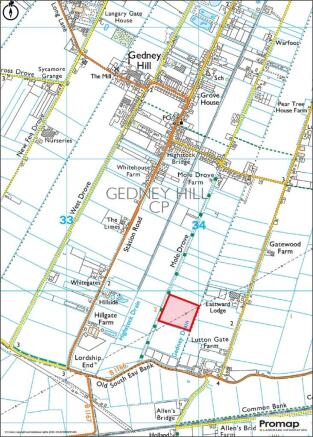
Mole Drove is situated approximately 1 mile east of Gedney Hill with the Market Town of Wisbech being approximately 11 miles to the east and the village of Thorney being approximately 7 miles south. Access to the land can be obtained via a gated entrance, situated within the hedgerow, on the east side of Mole Drove, Gedney Hill. In accordance with Ordnance Survey, 'other route with public access' is shown along Mole Drove. The exact nature of the rights of these routes and the restrictions may be checked with the local highway authority.
What 3 Words Location: ///EVOLVES.REFRAIN.REFILLS
DESCRIPTION:
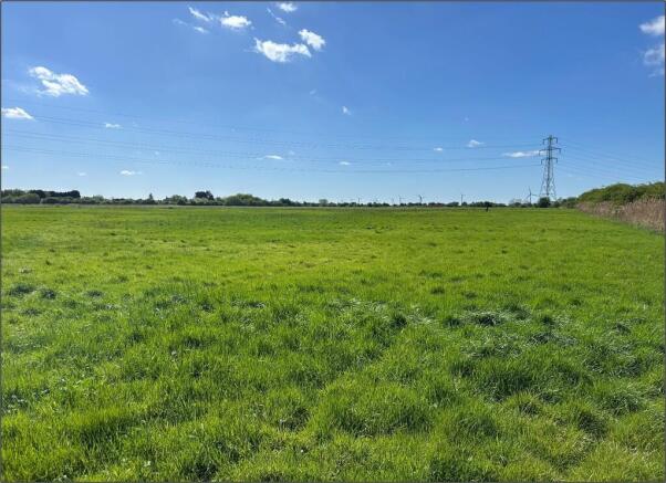
An opportunity to acquire 12.60 Acres (5.10 Hectares) or thereabouts of Grade 2 land situated to the east of Mole Drove, Gedney Hill, Spalding, Lincolnshire. The land is being offered for sale freehold, as a whole, and with the benefit of vacant possession. The land is shown outlined in red on the plan within these particulars. The land is currently pasture land and is classed as permanent pasture on the RPA mapping system. There is a hedge on the western boundary and a drain forming the eastern boundary. All sides are fenced with dykes to three sides. The area stated on the Rural Agency plan is 13.00 acres (5.26 hectares).
METHOD OF SALE:
The land is offered for sale freehold by Private Treaty. The Vendor reserves the right to conclude the sale by ´Best and Final´ offers. Interested parties who may wish to discuss any aspect of this should contact the Vendor´s Agent on Option 4.
LAND AND SOILS CLASSIFICATION:
The land is classified as Grade 2 on the Land Classification Map of England & Wales. The land is further classified by the Soil Survey of England and Wales as being part of the Wallasea 2 Soil Series which is further described as 'Deep stoneless clayey soils, calcareous in places. Some deep calcareous silty soils. Flat land often with low ridges giving a complex soil pattern.' And is capable of growing 'winter cereals and some sugar beet, potatoes, cereals and field vegetables.'
LAND AREA:
The land, as per H M Land Registry Title No. LL431604, extends to approximately 12.60 acres (5.10 hectares).
TENURE, POSSESSION AND RIGHT OF HOLDOVER:
The tenure of the land is freehold. Possession of the land will be available upon completion.
LAND DRAINAGE:
No recent land drainage schemes have been undertaken. There are no land drainage plans available.
SERVICES:
Mains water supplies a water trough in the field.
ACCESS - MOLE DROVE:
The field is accessed via Mole Drove and Mole Drove is a grass track defined on the Ordnance Survey map as 'other route with public access'. It is gated at both the northern and southern ends. The northern end leads directly off Highstock Lane which is part of the Public Highway and the southern end leads directly off the B1166 (Throckenholt Bank). It is believed Mole Drove is purely maintained by those parties who access their land via Mole Drove.
WAYLEAVES, RIGHTS OF WAY AND EASEMENTS:
The land is offered for sale subject to, and with the benefit, of all existing rights including rights of way whether public or private, light, support, drainage, water and electricity and other rights, easements, quasi-easements, and all wayleaves whether referred to specifically in these Particulars or not. It should be noted that the South Holland Internal Drainage Board have a Byelaw Right of Access adjacent to their drain which forms the eastern boundary of the field.
There is an electricity pylon situated to the eastern side of the field with associated overhead power lines, an annual payment is received in respect of this. Interested parties should satisfy themselves regarding any implications this may have on their intended use of the land.
SPORTING RIGHTS:
The Sporting Rights are included in the sale as far as owned by the Seller.
MINERALS AND TIMBER:
The mineral rights are included in the sale as far as owned by the Seller.
VALUE ADDED TAX:
Should a sale of the land or any right attached to it become a chargeable supply for the purposes of VAT, such Tax will be payable by the Purchaser(s) in addition to the contract price. All Guide Prices quoted, or prices discussed are exclusive of VAT.
TENANTRIGHT:
There will be no additional charge for Tenantright (if any).
DILAPIDATIONS:
There will be no allowance for dilapidations (if any).
CONTRACTS AND QUOTAS:
There are no contracts or quotas included within the sale of the land.
PLANS, AREAS, AND SCHEDULE:
The plans and areas have been prepared as accurately as reasonably possible and are based on the Ordnance Survey and Rural Land Registry Plans. The plans included in these Particulars are published for convenience and / or identification purposes only and although believed to be correct, the accuracy cannot be guaranteed. The purchaser(s) will be deemed to have satisfied themselves as to the description and extent of the property and the ownership of the boundaries.
HEALTH AND SAFETY:
All those entering on to the land should take great care both for themselves, their property and any part of the land or crops. Neither the Vendor nor the Agents are responsible for any injury or accident that occurs on the land.
VIEWING:
Strictly by appointment with the selling Agents. Any parties viewing the land do so entirely at their own risk and are responsible for ensuring their own safety. Mole Drove is gated at the northern and southern ends.
Brochures
Grade 2 Agricultural Land. Mole Drove, Gedney Hill

NEAREST STATIONS
Distances are straight line measurements from the centre of the postcode- Spalding Station9.2 miles
Notes
Disclaimer - Property reference 101505031453. The information displayed about this property comprises a property advertisement. Rightmove.co.uk makes no warranty as to the accuracy or completeness of the advertisement or any linked or associated information, and Rightmove has no control over the content. This property advertisement does not constitute property particulars. The information is provided and maintained by Longstaff Chartered Surveyors, Spalding. Please contact the selling agent or developer directly to obtain any information which may be available under the terms of The Energy Performance of Buildings (Certificates and Inspections) (England and Wales) Regulations 2007 or the Home Report if in relation to a residential property in Scotland.