Land at Knutsford Road, Cranage

- PROPERTY TYPE
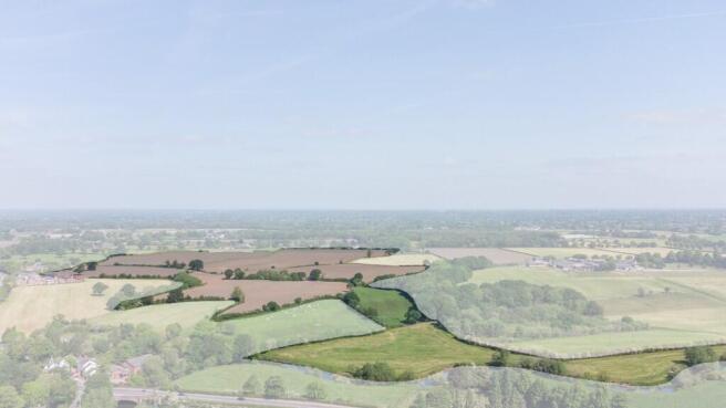
Farm Land
- SIZE
Ask agent
Key features
- 82.76 Acres (33.49 Ha)
- Good quality farmland
- Road frontage to both lots
- Potential for agricultural, equestrian or amenity use
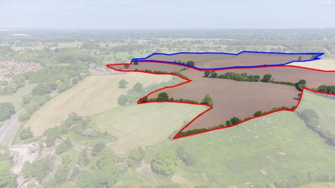
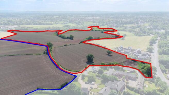
- Lot 1 (edged red) - 44.25 Acres (17.90 Ha)
- Lot 2 (edged blue) - 38.51 Acres (15.58 Ha)
Description
The land is classified as Grade 3 on the Soil Survey of England & Wales and the soils are classified as naturally wet very acid sandy and loamy soils. The boundaries are well-fenced, in the main with mature hedging.
Lot 1 (edged red)
44.25 Acres (17.90 Ha) predominantly in maize with some grass. The Lot consists of five fields, with a track extending from the access point on the A50 Knutsford Road partway through.
A copse of trees with small pits crosses part of the land, while the southern field borders the River Dane. Together, these features form an attractive landscape that supports a diverse range of wildlife, adding ecological value.
If sold separately, the purchaser of Lot 1 will be responsible for installing stock-proof fencing between the two Lots within six weeks of completion of the sale.
Lot 2 (edged blue)
38.51 Acres (15.58 Ha), currently in maize. The Lot is made up of one flat field with a grass track running through the centre. An access track provides road frontage to, and access from, Twemlow Lane.
Rights of Way and Easements
There are a number of public footpaths that cross both Lots. In addition a gas pipeline and sewerage pipe cross Lot 1.
The property is sold subject to and with the benefit of all rights including rights of way, whether public or private, light, support, drainage, water, telephone and electricity supplies and other rights and obligations, easements, quasi-easements and restrictive covenants, and all existing and proposed wayleaves or masts, pylons, stays, cable, drains and water, gas or other pipes, whether referred to in the Sales Particulars or not, and to the provisions of any Planning Scheme or County or Local Authorities without obligations on the part of the Sellers or their agents to specify them.
Nitrate Vulnerable Zone
The land is located within the Nitrate Vulnerable Zone as designated by DEFRA.
Services
Mains water is connected to Lot 1 only. With regards to Lot 2 it is understood that mains water and electric are available in the area, additional connection to these services would be at the cost of the buyer.
We are advised that the above services are available. Barbers Rural have not tested any apparatus, equipment, fittings etc or services to this property so cannot confirm that they are in working order. A buyer is recommended to obtain confirmation from their solicitor or surveyor.
Development Clawback
The land is sold subject to a development clawback. In the event that planning permission is granted for any kind of use over agricultural and equestrian within the next 25 years then the sellers or their heirs will be entitled to 25% of the increase in value.
Jodrell Bank Consulation Zone
Please note that the land falls within the Jodrell Bank Consultation Zone which limits some aspects of development.
Tenure
We are advised that the property is freehold with vacant possession on completion.
The land is currently let on a FBT which terminates on 31st September 2025. All necessary notices have been served. The completion will take place once the maize crop has been harvested.
For further information please download the full sales details or call the Agents on .
Brochures
sales detailsBrochure 2Land at Knutsford Road, Cranage

NEAREST STATIONS
Distances are straight line measurements from the centre of the postcode- Holmes Chapel Station1.1 miles
- Goostrey Station1.9 miles
- Plumley Station4.9 miles
About Barbers Rural Consultancy LLP, Market Drayton
Smithfield House Smithfield Road Market Drayton TF9 1EWNotes
Disclaimer - Property reference 14410. The information displayed about this property comprises a property advertisement. Rightmove.co.uk makes no warranty as to the accuracy or completeness of the advertisement or any linked or associated information, and Rightmove has no control over the content. This property advertisement does not constitute property particulars. The information is provided and maintained by Barbers Rural Consultancy LLP, Market Drayton. Please contact the selling agent or developer directly to obtain any information which may be available under the terms of The Energy Performance of Buildings (Certificates and Inspections) (England and Wales) Regulations 2007 or the Home Report if in relation to a residential property in Scotland.
Map data ©OpenStreetMap contributors.