Grumbla, Penzance
- PROPERTY TYPE
Land
- SIZE
Ask agent
Key features
- Equestrian holding
- 2 acres
- Stables & field shelter
- Storage containers
Description
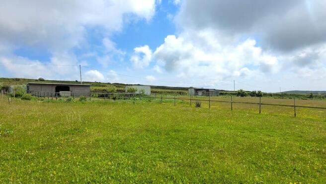
The Land
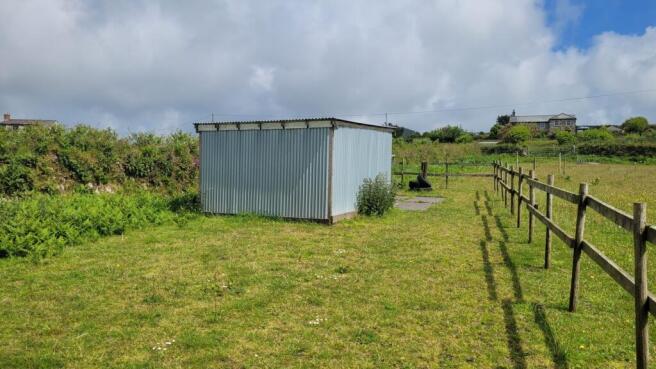
A lovely parcel of land extending to almost two acres with potential for a variety of uses. The land has been used by our clients for many years for horse grazing and whilst set up perfectly for equestrian use, the land is equally suited to alternative grazing, hobby farming, amenity space or conservation. The site comprises two field enclosures which are gently sloping in topography with a mixture of post and rail fencing and stone wall hedges complete with three vehicular gates onto the (tarmacked) public bridleway to the east. One of these gates opens into a large area of hard standing, providing ample space for the turning and parking of vehicles/trailers etc. and set on which are two shipping containers - previously used as tack and feed rooms - and a touring caravan, all of which are included in the sale.
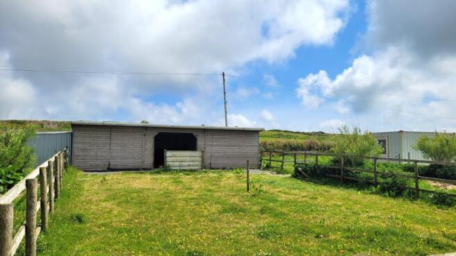
Stables & Shelters
A timber stable block (35'8" x 12' / 10.8m x 3.66m) offers two stables at either side of a covered centre and the whole is fitted with rubber matting. To the side of the stables are two shelters/additional stables (22' x 8'4" / 6.7m x 2.55m and 8' x 7'10" / 2.44m x 2.38m) ideal for smaller ponies or as use for hay stores and the like. Also set within the site is a field shelter (11'3" x 11' / 3.43m x 3.36m) with stable door.
Property Information
Services
Mains water (via sub-metered supply). None of these services have been tested and therefore no guarantees can be given. Interested parties are advised to make their own enquiries to the relevant service providers.
Wayleaves, Easements & Rights of Way
The sale will be subject to and with the benefit of all wayleaves, easements and rights of way as may exist. No public rights of way cross the land being offered for sale.
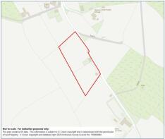
Particulars & Plan
Whilst every care is taken in the preparation of these particulars, their accuracy is not guaranteed and they do not constitute any part of an offer or contract. Any intending purchaser/s must satisfy themselves by inspection or otherwise as to the correctness of these particulars.
Location
The land is positioned in a very quiet location along a bridleway which serves as an access road to a few dwellings between the A3071 at Newbridge and Sancreed. Newbridge is less than 2 miles distant and offers a public house, whilst Penzance is within 5 miles and offers a whole range of everyday amenities and facilities as well as a mainline railway link to London (Paddington).
Viewing & Directions
Viewers may access the land for viewing purposes with sale particulars in hand, during daylight hours adhering to the Countryside Code. Please notify the agents Lodge & Thomas of your intended visit. Tel: Email:
Directions
From Newbridge proceed westbound along the A3071 towards St Just and approximately one and a half miles after leaving Newbridge, turn left into the track where there is a small nameplate showing "Botrea". Follow this lane for approximately 500m and the land will be found on the right hand side identified by a Lodge & Thomas for sale board.
what3words///admires.shuttled.mincing
Brochures
Brochure 1Grumbla, Penzance

NEAREST STATIONS
Distances are straight line measurements from the centre of the postcode- Penzance Station4.8 miles


Notes
Disclaimer - Property reference LAT221490. The information displayed about this property comprises a property advertisement. Rightmove.co.uk makes no warranty as to the accuracy or completeness of the advertisement or any linked or associated information, and Rightmove has no control over the content. This property advertisement does not constitute property particulars. The information is provided and maintained by Lodge & Thomas, Truro. Please contact the selling agent or developer directly to obtain any information which may be available under the terms of The Energy Performance of Buildings (Certificates and Inspections) (England and Wales) Regulations 2007 or the Home Report if in relation to a residential property in Scotland.
Map data ©OpenStreetMap contributors.