
Pond Farm, Aveton Gifford
- PROPERTY TYPE
Farm House
- BEDROOMS
4
- BATHROOMS
1
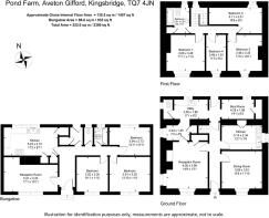
- SIZE
1,457 sq ft
135 sq m
- TENUREDescribes how you own a property. There are different types of tenure - freehold, leasehold, and commonhold.Read more about tenure in our glossary page.
Ask agent

Key features
- Approximately 79.92 acres (32.32 hectares) in all
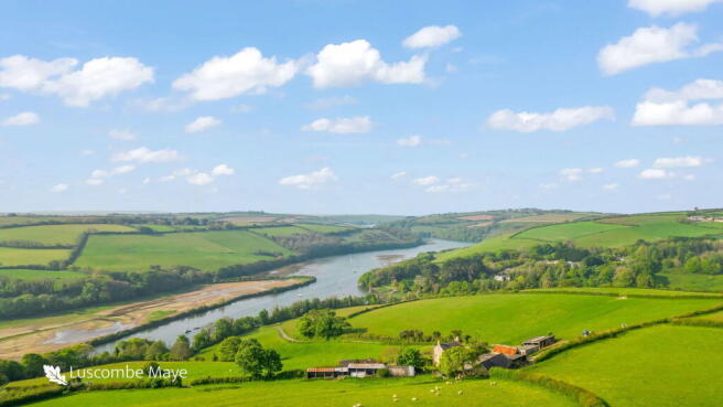
- Breathtaking views across the River Avon and the tidal estuary
- Range of Stone Barns (3,186 square feet) and Modern Farm Buildings (6,609 square feet) with potential for development (subject to planning)
- Offering the potential to create an iconic property in an unrivalled location in the heart of the South Hams
- In need of renovation works
- No onward chain
- For sale by Formal Tender with a tender closing date of Thursday 31st July 2025 at 12 noon
Description
DIRECTIONS
From Aveton Gifford, proceed along the tidal road towards Bigbury. Approximately half a mile along this road turn off to the right which will lead into the driveway leading up to Pond Farm.
What3Words Location: picked.operating.trip
SITUATION
Pond Farm is situated near the village of Aveton Gifford, between the villages of Aveton Gifford and Bigbury, in the South Hams area of South Devon and within an area designated as a National Landscape (formerly known as Area of Outstanding Natural Beauty).
The nearest town of Kingsbridge is about 4 miles away, the city of Plymouth some 15 miles to the west and the A38 dual carriageway expressway, connecting to the M5 motorway and national road network, being about 10 miles to the north.
DESCRIPTION
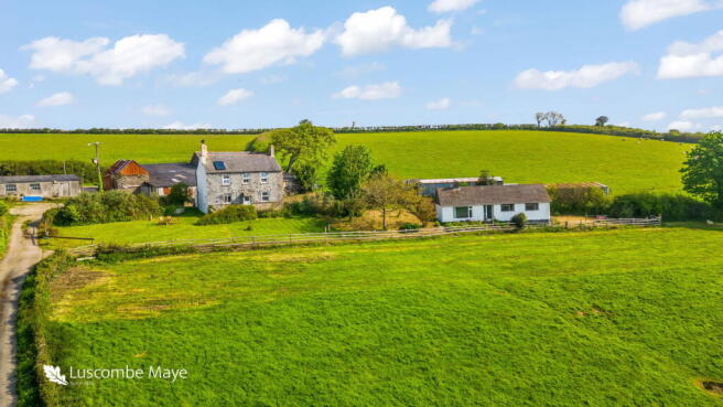
Pond Farm comprises a residential and livestock farm, to include a farmhouse, detached bungalow, range of traditional and modern farm buildings and some 79.92 acres of agricultural land, the full extent of which is outlined in red on the site plan.
The principal access to the farm is gained off the council maintained tidal road, between the villages of Aveton Gifford and Bigbury. Access is restricted to particular hours of the day based on tidal movement.
There are two alternative accesses to Pond Farm. Firstly, an alternative access may be gained over the public byway Drunkards Lane into the northern boundary of field parcel 3555.
The second alternative access to the farm may be gained via a Right of Way over Waterhead Lane to a gateway on the eastern boundary of field number 7925, however this is not currently in use. Both alternative access points are labelled and approximately shown by a brown hatched line on the site plan.
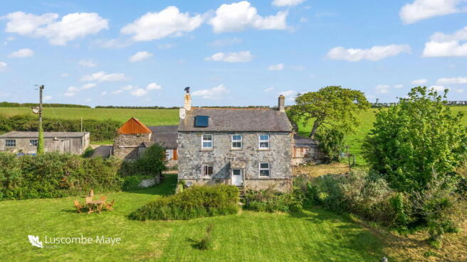
The Farmhouse
Not of listed status, the farmhouse is believed to have been constructed in 1830, built mainly of rendered solid stone walls with parts being slate hung and under a slate roof.
The property comprises the following accommodation: -
Ground Floor
Entrance Hall, Sitting Room, Dining Room, Kitchen, Rear Entrance Porch, Boot Room/Store, Utility Room, Separate WC
First Floor
Landing, Family Bathroom, 4 Bedrooms
Services (The Farmhouse)
Mains water, electric and private septic tank drainage. Solar panel on roof heats water for bathroom and utility room. Meters for the water supply can be identified on site plan by the letter M.
Pond Cottage (Bungalow)
A detached bungalow of Woolaway construction, built in approximately 1965/66 with an interlocking concrete tile roof. This property is subject to an Agricultural Tie whereby only those persons previously or currently working full time in agriculture or forestry are permitted to reside in the dwelling.
The property comprises the following accommodation:-
The property comprises the following accommodation:-
Entrance Hall, Sitting Room, Kitchen/ Dining Room, Separate WC, Bathroom, 3 Bedrooms, Rear Entrance Porch
Services (Pond Cottage)
Mains water (on the same meter as the farmhouse), electric and private septic tank drainage (both separate from the farmhouse). Economy 7 electric tariff by night for the water heater and night storage heaters.
Stone Barns
Extending to a total area of some 296 square metres (3,186 square feet) over two floors, the Stone Barns do not have planning consent for change of use to residential but offer the potential for such change of use either as full residential units or as holiday ancillary use. These may be summarised as follows:-
1. The Barn – Internal 14.25m x 5m over 2 floors (142 sq. m)
2. The Stable – Internal 6.85m x 5.25m over 2 floors (71.93 sq. m)
3. The Coal Store – External 9m x 4.6m over 2 floors (82.8 sq. m)
Modern Farm Buildings
Within close proximity of the farmhouse (and partly amongst and linked to the stone barns) is a range of modern farm buildings, extending to a total area of some 614 square metres (6,609 square feet). Brief details of which are as follows:-
4. Lean-to Cattle Yard – 21.30m x 12.2m (259.86 sq. m)
5. Nissan Hut (Workshop) – 10.82m x 5.10m (55.19 sq. m
6. Woodstore / Sheep shed – 14.82m x 6.07m (89.96 sq. m)
7. Lambing shed – 12.80m x 5.18m (66.30 sq. m) to include overhang
8. Cow Shed & Dairy– external overall 10.10m x 5.25m (53.03 sq. m)
9. Fog Den – external 12.0m x 7.55m (90.60 sq. m)
Note – the contents of the Stone Barns and Modern Farm buildings as listed above, are sold as seen. No machinery to be included.
The Lands
The full extent of the land amounts to some 79.92 acres (32.32 hectares). The land wraps around the farmhouse and buildings providing a significant amount of protection from other properties.
The land in the past has been used for livestock grazing and grass conservation purposes but offers the potential for other uses subject to obtaining the necessary consents.
Water supply (The Land)
The land to the east and south side is served by a well water supply. There are three wells located on the land, of which one is currently in use. The approximate locations of the wells are marked on the site plan below.
The remaining water troughs within close proximity to the house & buildings are fed by the mains supply that also serves the farmhouse.
A schedule of the land is set out below :-
Field Number Acres Hectares Description
SX6846 3884 2.20 0.89 Woodland
SX6847 1112 0.35 0.14 Woodland
SX6847 7308 2.13 0.86 Woodland
SX6846 4292 5.50 2.22 Permanent Pasture
SX6847 1722 5.09 2.06 Permanent Pasture
SX6847 2103 6.40 2.59 Rough Grassland/scrub
SX6847 3109 5.40 2.18 Permanent Pasture
SX6847 3126 6.28 2.54 Permanent Pasture
SX6847 3240 7.02 2.84 Permanent Pasture
SX6847 4111 8.62 3.49 Permanent Pasture
SX6847 4727 2.87 1.16 Permanent Pasture
SX6847 5809 7.76 3.14 Permanent Pasture
SX6847 7925 4.77 1.93 Permanent Pasture
SX6847 5923 3.16 1.28 Permanent Pasture
SX6847 5320 0.10 0.04 Permanent Pasture
SX6847 6115 0.74 0.30 Permanent Pasture
SX6847 6513 0.21 0.08 Fruit trees/ garden
SX6847 7119 4.74 1.92 Permanent Pasture
SX6847 3555 5.41 2.19 Permanent Pasture
- 1.17 0.47 House, Curtilage, Buildings, Driveway
Total 79.92 32.32
PUBLIC FOOTPATHS
Public footpaths proceed through part of the farm along the south-west boundary and along the northern end of field parcel 3555. The routes of the footpaths are labelled and approximately shown on the site plan by means of a purple line.
BOUNDARY OWNERSHIP
TENURE
The property is held on a freehold basis with vacant possession being available on legal completion.
SPORTING AND MINERAL RIGHTS
All sporting and mineral rights are included in the sale, as far as are known.
ENVIRONMENTAL STEWARDSHIP SCHEME AGREEMENTS
Pond farm is not subject to any Environmental Stewardship Scheme agreements.
LOCAL AUTHORITY & COUNCIL TAX
South Hams District Council, Follaton House, Plymouth Road, Totnes, Devon TQ9 5NE.
Pond Farm falls within Council Tax Band C and the amount payable for 2023/24 is £2,106.40.
Pond Cottage falls within Council Tax Band A and the amount payable for 2023/24 is £1,579.81.
EPC
Pond Farmhouse has an EPC rating F with potential for C.
Pond Cottage (Bungalow) has an EPC rating of F also with potential for C.
The full EPC ratings are available on the listing.
GUIDE PRICE
£1,325,000
METHOD OF SALE
Pond Farm is being offered for sale by Formal Tender (unless sold prior), with a closing date of Thursday 31st July 2025 at 12 noon.
Tenders must be submitted to 62 Fore Street, Kingsbridge, TQ7 1PP in an envelope clearly marked 'Pond Farm’.
Buyers who wish to submit a tender will be required to sign a legal contract, available from the solicitor acting for the seller and provide a deposit of 10% of their offer price, as their tender. If either of these two component parts are not submitted, their tender risks being declined.
Moreover, the successful purchaser will be liable to pay the sum of 1% of the agreed purchase price as an administration fee in addition to their tender.
A tender which is accepted by the seller will be treated as a binding contract and immediately constitute an exchange of contracts. Legal completion and payment of the balance of the purchase price will follow 4 months later (or earlier by mutual agreement).
The seller does not undertake to accept the highest or any of the offers and the seller reserves the right to withdraw, alter or amend the way in which the land is offered for sale.
LEGAL PACK
A copy of the legal pack for the land may be obtained from the seller’s solicitors, Windeatts of 48 Fore Street, Kingsbridge. Attention: Richard Wing Tel: or e-mail richard.
VIEWINGS
Strictly by appointment with the Sole Selling Agents, Luscombe Maye of 62 Fore Street, Kingsbridge, TQ7 1PP. Telephone for details.
HEALTH & SAFETY
Brochures
Brochure 1- COUNCIL TAXA payment made to your local authority in order to pay for local services like schools, libraries, and refuse collection. The amount you pay depends on the value of the property.Read more about council Tax in our glossary page.
- Band: C
- PARKINGDetails of how and where vehicles can be parked, and any associated costs.Read more about parking in our glossary page.
- Yes
- GARDENA property has access to an outdoor space, which could be private or shared.
- Private garden
- ACCESSIBILITYHow a property has been adapted to meet the needs of vulnerable or disabled individuals.Read more about accessibility in our glossary page.
- Ask agent
Pond Farm, Aveton Gifford

Add an important place to see how long it'd take to get there from our property listings.
__mins driving to your place
Get an instant, personalised result:
- Show sellers you’re serious
- Secure viewings faster with agents
- No impact on your credit score
Your mortgage
Notes
Staying secure when looking for property
Ensure you're up to date with our latest advice on how to avoid fraud or scams when looking for property online.
Visit our security centre to find out moreDisclaimer - Property reference S1336425. The information displayed about this property comprises a property advertisement. Rightmove.co.uk makes no warranty as to the accuracy or completeness of the advertisement or any linked or associated information, and Rightmove has no control over the content. This property advertisement does not constitute property particulars. The information is provided and maintained by Luscombe Maye Farms & Land, Kingsbridge. Please contact the selling agent or developer directly to obtain any information which may be available under the terms of The Energy Performance of Buildings (Certificates and Inspections) (England and Wales) Regulations 2007 or the Home Report if in relation to a residential property in Scotland.
*This is the average speed from the provider with the fastest broadband package available at this postcode. The average speed displayed is based on the download speeds of at least 50% of customers at peak time (8pm to 10pm). Fibre/cable services at the postcode are subject to availability and may differ between properties within a postcode. Speeds can be affected by a range of technical and environmental factors. The speed at the property may be lower than that listed above. You can check the estimated speed and confirm availability to a property prior to purchasing on the broadband provider's website. Providers may increase charges. The information is provided and maintained by Decision Technologies Limited. **This is indicative only and based on a 2-person household with multiple devices and simultaneous usage. Broadband performance is affected by multiple factors including number of occupants and devices, simultaneous usage, router range etc. For more information speak to your broadband provider.
Map data ©OpenStreetMap contributors.