
Plumpton, Towcester, Northamptonshire, NN12

- PROPERTY TYPE
Detached
- BEDROOMS
5
- BATHROOMS
2
- SIZE
Ask agent
- TENUREDescribes how you own a property. There are different types of tenure - freehold, leasehold, and commonhold.Read more about tenure in our glossary page.
Freehold
Key features
- Offers invited 14/7/25
- 5 bedroom farmhouse in need of renovation
- Traditional farm buildings
- Range of livestock buildings and grain store
- Arable and pasture
- About 650.02 acres
- EPC Rating = G
Description
Description
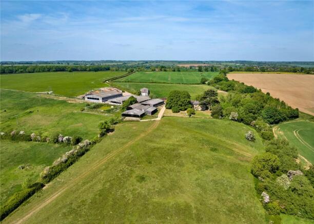
An attractive residential mixed farm with a 5 bedroom farmhouse in need of renovation, traditional farm buildings, an extensive range of livestock buildings and grain store, arable pasture and woodland.
Please note that that VAT is payable on the purchase price.
Oakley Bank Farm is available as a whole or in four Lots.
LOT 1 –
OAKLEY BANK FARMHOUSE
27.93 acres (11.3 hectares)
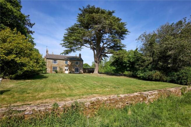
An attractive ironstone built farmhouse under a slate roof, Oakley Bank Farmhouse enjoys a private setting with south facing views out over the farm.
The farmhouse is accessed via a private drive that goes past the farm buildings and arrives in a semi-courtyard setting to the west of the house where a range of traditional farm buildings provide a mixture of garaging, storage and stabling. Surrounded by gardens, the house has a south facing partly walled lawn which extends to a ha-ha with a field of pasture beyond.
To the rear of the farmhouse, the courtyard-style garden provides a sheltered garden and terrace dining area. The front door opens into a generous entrance hall. The reception rooms lead off the entrance hall and comprise a dining room and drawing room, both with open fireplaces. From the hallway is also a cellar. To the rear and side of the house is the sitting room, kitchen, downstairs bathroom and former dairy which has been used as a larder and store room. Stairs lead to the first floor with five bedrooms, some with open fireplaces, and a family bathroom. There is an open landing space which could accommodate a study or be enclosed to provide an additional bedroom or bathroom.
Accessed via an external staircase is a loft area at first floor level. Currently accessed via a ladder is the second floor which has been boarded out and could, subject to installing a proper staircase, provide an additional two bedrooms or useful storage space.
The former dairy, adjoining stores/outhouses and loft area could, subject to planning, be incorporated into the house more efficiently to provide better living space and accommodation.
It should be noted that the farmhouse has not been occupied since Autumn 2020.
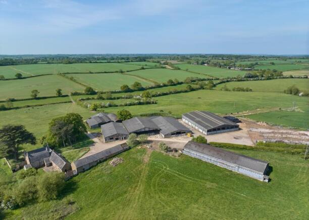
OUTBUILDINGS
Adjacent to the farmhouse is a former threshing barn of ironstone under a fibre cement roof construction with a mezzanine floor at one end. There are also adjoining red brick stores, former piggery, stabling and garaging. Subject to securing the necessary planning permission, these buildings lend themselves to conversion to ancillary uses including secondary accommodation, party barn, home office or gym.
FARM BUILDINGS
Set away from the farmhouse are an extensive range of livestock buildings, originally forming part of a dairy, and a grain store.
FARMLAND
The land within Lot 1 comprises predominately permanent pasture and split into a number of fields by mature hedges and fenced for cattle.
Extending to about 27.93 acres (11.3 hectares) in total, Lot 1 comprises about 20.20 acres (8.17 hectares) of permanent pasture and 1.53 acres (0.619 hectares) of arable, leaving about 6.21 acres (2.51 hectares) of miscellaneous areas including the farmhouse, gardens, buildings and other areas.
LOT 1B –
LAND OFF THE DRIVE TO OAKLEY BANK FARM
20.38 acres (8.24 hectares)
A single arable field extending to about 20.3 acres (8.2 hectares) that is accessed off the drive to Oakley Bank Farm and bordered by mature hedges.
LOT 2 –
LAND AT OAKLEY BANK FARM
308.53 acres (124.87 hectares)
Adjoining Oakley Bank Farm and benefitting from direct road access, the land is a significant block of mixed arable and pasture which totals 308.53 acres (124.87 hectares). The land is split between 267.03 acres (108.06 hectares) of arable, 57.75 acres (23.37 hectares) of permanent pasture and 4.13 acres (1.68 hectares) of woodland and other miscellaneous areas.
Located to the north east of Lot 2 is a range of dilapidated traditional farm buildings. Comprising a red brick and slate threshing barn with part red brick floor and an L-shaped cow byre of red brick and part tile, part corrugate iron roof construction. Historic maps suggest that these buildings formed two sides of a crewyard or cattle yard.
The arable land is generally suited to modern machinery with the primary access taken from the public highway at Plumpton.
The majority of the permanent pasture is found along the water meadows along the valley, in which a River Tove tributary runs, that splits the lot on west to east axis. On the whole, these fields are fenced for cattle and bordered by mature hedges. Some fields feature ridge and furrow.
There is a former quarry and area of woodland south east of Plumpton. Access is generally taken from the Weston to Woodend/Blakesley road, although there is an access to the south east via the Oxford Lane, a byway, of the Weston to Wappenham road.
LOT 3 –
LAND AT PLUMPTON
293.18 acres (118.64 hectares)
Extending to about 293.18 acres (118.64 hectares) in total, the land at Plumpton is a predominantly arable block of farmland interspersed with permanent pasture. The land is split between 219.04 acres (88.64 hectares) of arable, 68.88 acres (27.87 hectares) of permanent pasture and 5.26 acres (2.13 hectares) of woodland and other miscellaneous areas.
The land to the north, is predominately down to arable, accessed off the public highway to the north of Plumpton. Farmed within an arable rotation, including Sustainable Farming Incentive options, fields are bordered by mature hedges.
The permanent pasture is mainly found to the south of the Lot, with access off the public highway on the southern edge of the hamlet of Plumpton. In general, the pasture is fenced for cattle and bordered by mature hedges. Some fields feature ridge and furrow.
There is a pond with a timber summerhouse at the southern end of the Lot. This is used under licence by a previous tenant’s family.
Location
Oakley Bank Farm is situated near the hamlet of Plumpton in south Northamptonshire, and is found equidistance between the popular villages of Weston and Blakesley.
The local area enjoys a variety of services and amenities including: Browns (village shop), Chapel & Co (café) and the Bartholomew Arms pub in Blakesley;The Crown Inn at Weston; Forge Coffee (café), Mumford’s Butchers and The Red Lion in Culworth; Medical Centre, Post Office, the Butcher’s Arms pub and Hunt’s butchers in Green’s Norton.
More extensive shopping, services and cultural experiences can be found in the nearby towns of Towcester and Banbury, and further afield at Northampton, Milton Keynes, Oxford and Stratford upon Avon. A variety of sports facilities and clubs exist in the area offering rugby, tennis, football, cricket, padel, hockey and netball, along with motorsport at Silverstone.
There are a wide choice of schools in the area with primary schools in nearby Blakesley, Lois Weedon, Culworth and Green’s Norton and secondary schools in Towcester and Middleton Cheney. Independent preparatory schools include Winchester House and Beachborough at Brackley and senior schools include Stowe, Tudor Hall and Bloxham.
The wider area benefits from good communication links by road and rail. The farm is situated near the A5 at Towcester which gives good access to Milton Keynes Railway Station (London Euston from 32 minutes) and the A43 which links the M1 and M40 motorways.
Acreage: 650.02 Acres
Directions
Post Code
Oakley Bank Farm, NN12 8SE
what3words
Lots 1 and 1B: entire.paying.mermaids
Lot 2: trucked.bulbs.private
Lot 3: ballpoint.fizzle.bonkers
what3words gives every 3m x 3m square in the world a unique 3 word address. These describe the precise entrance to Oakley Bank Farm and the two offlying land lots
Additional Info
Viewing
Strictly by appointment with Savills. Prior to making an appointment to view, we strongly recommend that you discuss any particular points which are likely to affect your interest in the property with a member of staff who has seen the property, in order that you do not make a wasted journey.
Brochures
Web Details- COUNCIL TAXA payment made to your local authority in order to pay for local services like schools, libraries, and refuse collection. The amount you pay depends on the value of the property.Read more about council Tax in our glossary page.
- Band: F
- PARKINGDetails of how and where vehicles can be parked, and any associated costs.Read more about parking in our glossary page.
- Yes
- GARDENA property has access to an outdoor space, which could be private or shared.
- Yes
- ACCESSIBILITYHow a property has been adapted to meet the needs of vulnerable or disabled individuals.Read more about accessibility in our glossary page.
- Ask agent
Plumpton, Towcester, Northamptonshire, NN12

Add an important place to see how long it'd take to get there from our property listings.
__mins driving to your place
Get an instant, personalised result:
- Show sellers you’re serious
- Secure viewings faster with agents
- No impact on your credit score
Your mortgage
Notes
Staying secure when looking for property
Ensure you're up to date with our latest advice on how to avoid fraud or scams when looking for property online.
Visit our security centre to find out moreDisclaimer - Property reference OXR250044. The information displayed about this property comprises a property advertisement. Rightmove.co.uk makes no warranty as to the accuracy or completeness of the advertisement or any linked or associated information, and Rightmove has no control over the content. This property advertisement does not constitute property particulars. The information is provided and maintained by Savills Rural Sales, Oxford. Please contact the selling agent or developer directly to obtain any information which may be available under the terms of The Energy Performance of Buildings (Certificates and Inspections) (England and Wales) Regulations 2007 or the Home Report if in relation to a residential property in Scotland.
*This is the average speed from the provider with the fastest broadband package available at this postcode. The average speed displayed is based on the download speeds of at least 50% of customers at peak time (8pm to 10pm). Fibre/cable services at the postcode are subject to availability and may differ between properties within a postcode. Speeds can be affected by a range of technical and environmental factors. The speed at the property may be lower than that listed above. You can check the estimated speed and confirm availability to a property prior to purchasing on the broadband provider's website. Providers may increase charges. The information is provided and maintained by Decision Technologies Limited. **This is indicative only and based on a 2-person household with multiple devices and simultaneous usage. Broadband performance is affected by multiple factors including number of occupants and devices, simultaneous usage, router range etc. For more information speak to your broadband provider.
Map data ©OpenStreetMap contributors.