

Cookbury, Holsworthy, Devon, EX22

- PROPERTY TYPE
Land
- SIZE
3,623,321 sq ft
336,618 sq m
Key features
- 83 acres
- Range of farm buildings
- Quiet rural location.
Description
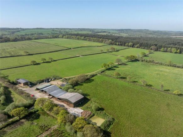
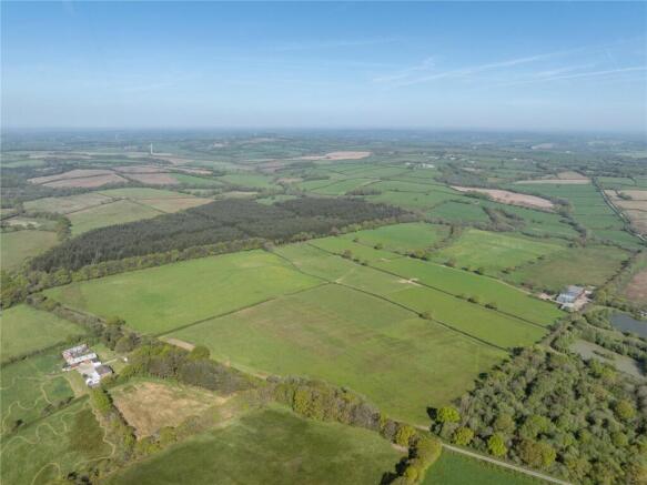
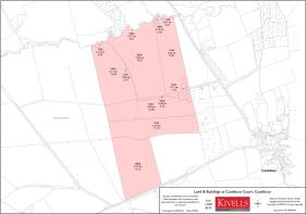
Description
The land and buildings at Cookbury Court extend in all to some 83.18 acres (33.67 hectares) and is approached from the parish road over a hardcore lane (a right of way), leading in turn to a yard area and
BALE SHED - 60'8" x 32'6" x 19' to eaves (18.5m x 9.9m x 5.8m) Steel frame and profile sheet cladding.
Lean-To TRACTOR SHED—60'4" x 27'7" (18.4m x 8.4m) Steel stanchions with corrugated elevations under a profile sheet roof.
CATTLE SHED - 59'1" x 59'1" (18m x 18m) Steel portal frame, concrete floor with scrape passage and feed barriers.
LEAN-TO OFF/ COVERED DUNG STORE - 59'1" x 19' (18m x 5.8m) Concrete walls, part concrete floor.
Lean-to Cattle House - 59'1" x 30'2" (18m x 9.2m) Steel and timber uprights with concrete walling.
CATTLE SHED - 59'1" x 83'4" (18m x 25.4m) Steel frame with concrete and timber walling.
Earth bunded SLURRY PIT with concrete floor.
The land is very gently sloping and divided into good sized enclosures with fenced natural hedge bank boundaries.
Access is from both the adjoining parish road on the lands southern boundary or from the yard and a useful stone cow track leads out through the first field.
Important Information
Method of sale: The property will be offered for sale by Private Treaty.
Services: There are no mains services connected, however they may be in the vicinity. Prospective buyers must make their own enquiries as to connection and cost of same.
Stewardship Scheme: The land is not subject to an stewardship agreement.
Tenure: Freehold with vacant possession upon completion.
Farm & Location Plan: The farm plan is based on ordnance survey extracts, and the areas are not guaranteed and purchasers must satisfy themselves as to their accuracy.
Boundaries: Any purchaser shall be deemed to have full knowledge of all boundaries and neither vendor nor the vendor’s agents will be responsible for defining the boundaries or the ownership thereof. Should any dispute arise as the boundaries or any points on the particulars or plans or the interpretation of them, the question shall be referred to the vendors agent whose decision acting as experts shall be final.
Local Authority: Torridge District Council. Bideford.
Directions
Postcode = EX22 7YJ
What3Words = ///reprints.pace.already
Viewings
Intending purchasers may inspect the property at a time of their choosing bearing a copy of these details. Please ensure that in making your inspection you do so with due care, taking responsibility for your actions. In particular please do not climb gates but open same and leave them shut where found shut and wear suitable footwear.
Important
We would like to inform prospective purchasers that these sales particulars have been prepared as a general guide only. A detailed survey has not been carried out. If there are any important matters likely to affect your decision to buy, please contact us before
viewing the property.
Brochures
ParticularsCookbury, Holsworthy, Devon, EX22

NEAREST STATIONS
Distances are straight line measurements from the centre of the postcode- Okehampton Station13.8 miles

Notes
Disclaimer - Property reference HAG250035. The information displayed about this property comprises a property advertisement. Rightmove.co.uk makes no warranty as to the accuracy or completeness of the advertisement or any linked or associated information, and Rightmove has no control over the content. This property advertisement does not constitute property particulars. The information is provided and maintained by Kivells, Land & Farm Sales. Please contact the selling agent or developer directly to obtain any information which may be available under the terms of The Energy Performance of Buildings (Certificates and Inspections) (England and Wales) Regulations 2007 or the Home Report if in relation to a residential property in Scotland.
Map data ©OpenStreetMap contributors.