

Buxhall, Stowmarket, Suffolk, IP14

- PROPERTY TYPE
Barn Conversion
- SIZE
Ask agent
- TENUREDescribes how you own a property. There are different types of tenure - freehold, leasehold, and commonhold.Read more about tenure in our glossary page.
Freehold
Key features
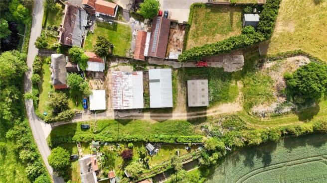
- Plot of approx. 0.5 acres (sts)
- Approved Change of Use from agricultural buildings to dwellings. As well as approval for the building operations reasonably necessary for conversion.
- Approved under Class Q on 22n April 2025
- Babergh District Council Planning ref: DC/25/00643
- Plans by Hollins Architects. Tel
- Consent for two 4-bedroom homes, and two 2-bedroom homes
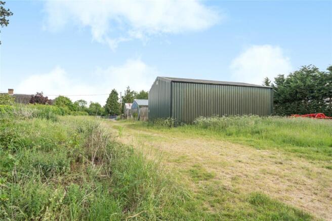
- Abutting beautiful farmland in a picturesque setting
- Barn A – 245 sq m
- Barn B – 79 sq m each
- Barn C – 165 sq m
Description
An exciting opportunity to convert three existing agricultural barns into four modern converted dwellings on a plot size of approximately half an acre (STS).
Barn A is proposed as a detached 4 bed, two storey dwelling GIA 245 sq m.
Barn B1 and B2 are proposed as semi-detached 2-bedroom single storey dwellings GIA 79 sq m each.
Barn D is proposed as a detached 4-bedroom single storey dwelling 165 sq m.
Each dwelling is set to have allocated parking spaces and individual gardens as shown in the plans.
Plans were prepared by Hollins Architects of Framlingham (Tel. ), to show the potential designs for each dwelling.
Note, there is an additional barn with plans drawn to allow for an annexe to Barn D.
PLANNING
Application for Prior Approval of Change of Use of Agricultural Buildings to Dwellinghouses, and for building operations reasonably necessary for conversion has been approved by Babergh District Council.
Planning Reference: DC/25/00643
Copies of the Approval and drawings are available from the agents, and on the Babergh District Council Planning Portal:
DISTANCES
Stowmarket - 3 miles (approx. 90 mins to London’s Liverpool Street Station)
A14 - 4.6 miles
Bury St Edmunds - 11.6 miles
DIRECTIONS (IP14 3DW)
From Ipswich, travel North along the A14. Take junction 49, followed by the second exit at the first roundabout, and the first exit of the next one. Follow Tot Hill Road for just under a mile, before turning left towards Harleston. Follow Haughley road for approx. 1.3 miles, turning right onto Cutler’s Lane, and following signs to Buxhall. At the end of Cutler’s Lane turn left onto Lower Road, following for 0.4 miles. Turn right at the sign for Buxhall, and follow this road for 0.7 miles, turning right when you see the sign for Mill Road. Shortly after, you will see a collection of barns on your right signed Highams.
What3words: ///corrects.smelter.impulses
PROPERTY INFORMATION
Services: Buyer is to satisfy themselves with the connection of services. Water supply to field to be maintained.
Mobile: Outdoor signal likely with EE, Three, O2, and Vodafone (Source: Ofcom)
Broadband: Ultrafast Broadband available in the area (Source: Ofcom)
EPC: TBC
Council Tax: TBC
Tenure: Freehold
Flood Risk: Very Low (Source: Gov.uk)
Community Infrastructure Levy (CIL): It is our understanding that the site will not be liable for CIL.
Viewings: By appointment with Jackson-Stops.
Brochures
Particulars- COUNCIL TAXA payment made to your local authority in order to pay for local services like schools, libraries, and refuse collection. The amount you pay depends on the value of the property.Read more about council Tax in our glossary page.
- Band: TBC
- PARKINGDetails of how and where vehicles can be parked, and any associated costs.Read more about parking in our glossary page.
- Yes
- GARDENA property has access to an outdoor space, which could be private or shared.
- Yes
- ACCESSIBILITYHow a property has been adapted to meet the needs of vulnerable or disabled individuals.Read more about accessibility in our glossary page.
- Ask agent
Energy performance certificate - ask agent
Buxhall, Stowmarket, Suffolk, IP14

Add an important place to see how long it'd take to get there from our property listings.
__mins driving to your place
Get an instant, personalised result:
- Show sellers you’re serious
- Secure viewings faster with agents
- No impact on your credit score


Your mortgage
Notes
Staying secure when looking for property
Ensure you're up to date with our latest advice on how to avoid fraud or scams when looking for property online.
Visit our security centre to find out moreDisclaimer - Property reference IPS250130. The information displayed about this property comprises a property advertisement. Rightmove.co.uk makes no warranty as to the accuracy or completeness of the advertisement or any linked or associated information, and Rightmove has no control over the content. This property advertisement does not constitute property particulars. The information is provided and maintained by Jackson-Stops, Ipswich. Please contact the selling agent or developer directly to obtain any information which may be available under the terms of The Energy Performance of Buildings (Certificates and Inspections) (England and Wales) Regulations 2007 or the Home Report if in relation to a residential property in Scotland.
*This is the average speed from the provider with the fastest broadband package available at this postcode. The average speed displayed is based on the download speeds of at least 50% of customers at peak time (8pm to 10pm). Fibre/cable services at the postcode are subject to availability and may differ between properties within a postcode. Speeds can be affected by a range of technical and environmental factors. The speed at the property may be lower than that listed above. You can check the estimated speed and confirm availability to a property prior to purchasing on the broadband provider's website. Providers may increase charges. The information is provided and maintained by Decision Technologies Limited. **This is indicative only and based on a 2-person household with multiple devices and simultaneous usage. Broadband performance is affected by multiple factors including number of occupants and devices, simultaneous usage, router range etc. For more information speak to your broadband provider.
Map data ©OpenStreetMap contributors.