Pinchbeck
- PROPERTY TYPE
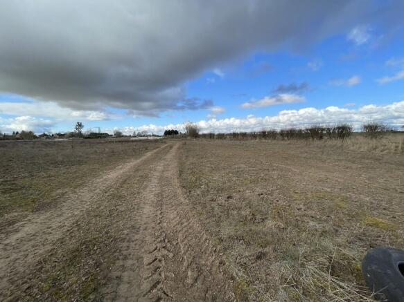
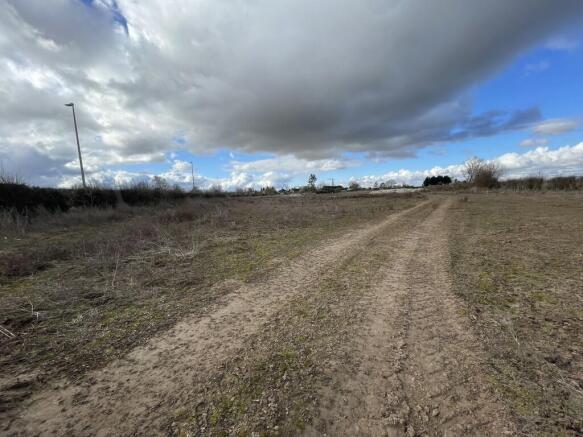
Land
- SIZE
424,710 sq ft
39,457 sq m
Key features
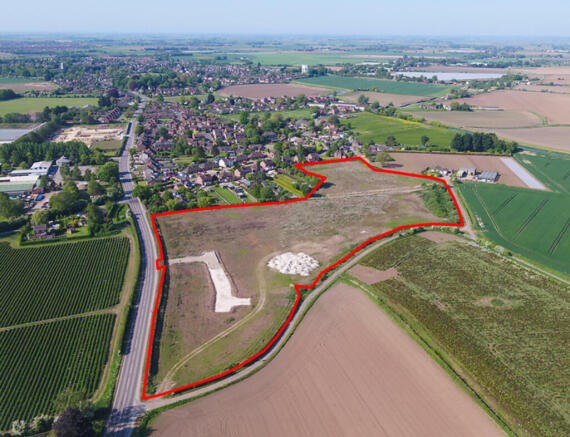
- Site area 9.75 acres
- Implemented Planning Consent for 63 Units
- High Profile Position on Surfleet Road
Description
Pinchbeck is within easy walking distance of the site, most of which can be approached via small C-Class roads and a footpath known as Gallery Walk. More extensive market town facilities are available in Spalding, which offers retail, banking and leisure facilities, extensive educational establishments (both Primary and Secondary) and a number of other facilities including Springfields Outlet Centre. Nearby market towns including Boston, Sleaford, Grantham, Bourne and Stamford are all within easy reach as is the expansion city of Peterborough lying some 20miles to the southwest.
Spalding has good transport facilities including an extensive local bus network and Spalding Railway Station with connections going south to Peterborough (from which main line journey time to Kings Cross is less than 50 minutes). Train connections going north to Sleaford, Lincoln and Doncaster.
The Lincolnshire and Norfolk coasts are both within easy travelling distance and other recreational facilities in the area including golf (Spalding Golf Club with well established course at Surfleet) other golf courses at Boston, Sleaford, Stamford and Peterborough. Trout fishing at Rutland Water, sailing on the River Welland in Spalding and other local sports clubs including squash, tennis, cricket, hockey and rugby. Spalding also boasts a successful local town football side and grounds.
The site offers the opportunity to provide an interesting planning mix for which consent has been granted for 63 dwellings with access from Surfleet Road in a relatively quiet location since the Spalding Bypass was built. It has easy access into the local road network with agricultural uses to the north and west with established residential property to the south.
Whilst we believe that mains services are available in the locality, it will be the responsibility of interested parties to carry out their own specific enquiries with the relevant service providers as to the availability, capacity and practical connection, together with relevant cost implications for accessing services to the site.
Planning Consent has been granted for 63 dwellings. A summary of the present consents are:-
H14-0137-19 - Full Proposed development of 63 houses with vehicular access from Surfleet Road - Granted 20 July 2020 subject to a Section 106 agreement (dated 03 July 2020)
H14-0259-23 - A repeat of the approval quoted above (identical plans) but with conditions adjusted to allow for permission implementation. The previous S106 has been carried forward to this permission (deed of variation dated 28 June 2023)
H14-0691-23 - A Certificate of Lawfulness has been granted to confirm that planning consent H14-0259-23 has been implemented, by virtue of the partial construction of its access. The approved site layout is drawing reference A1273-10 rev E (as approved by H12-0259-23).
H14-0766-23 - Condition Compliance, Details of a scheme to deal with contamination (part 1 of Condition 4 of H14-0259-23).
It is important that interested parties thoroughly investigate the planning history on the site and the requirements for additional information as contained in the conditioned consents including ground conditions/potential contamination/remediation measures.
TENURE The Tenure of the land is Freehold.
POSSESSION Vacant possession will be available upon completion.
The land is offered for sale as a whole, with the benefit of freehold tenure and vacant possession.
UPLIFT / CLAWBACK PROVISION There will be an uplift/clawback provision should the development exceed 63 units, based on the increase value of the site consequent to any additional plots being secured. Such payment to be made upon the grant of an alternative/additional planning consent/s. The payment due will be at a rate of 35% of any increase in value of the site consequent to the varied planning consent which will be effective for a period of 15 years from the date of the completion of the original sale.
VAT The land has not been opted to Tax as this present time, consequently no VAT is payable in addition.
ALTERNATIVE USES OF ALL OR PART Should alternative uses of the site be consented for all or part with the resulting value in excess of the Sale Price, then an uplift/clawback payment will be due in accordance with the provision as mentioned above.
The viewing of the site is by prior appointment. Interested parties must contact the Residential Development Land Department of R Longstaff & Co LLP on Tel: - Email:
Note: All parties entering onto the property do so entirely at their own risk and neither the Vendors nor their Agents will accept any liability for damage to persons or property as a result of being on the site. Great care should be taken at all times to avoid trip hazards and other potential areas of danger on site.
IDB DRAINS It should be noted that the drains on the west and south sides of the site fall within the responsibility of the Welland and Deepings Internal Drainage Board who have Byelaw regulations/controls restricting any permanent above ground feature with their standard 9 metre easement corridor.
For information concerning such Byelaw controls which are in place for cleansing, repair and maintenance of water courses enquiries should be directed to the Welland and Deepings Internal Drainage Board (contact details provided later within these Particulars).
REGISTERED TITLES The land is registered under two titles being LL387241 and LL133529.
PLANNING DESIGN A designed scheme has already been approved for the site and reference to this should be made as per the planning information provided earlier in these particulars.
All interested parties are recommended to contact the South Holland District Council Planning Department to discuss any aspect concerning planning/design variation etc.
TREES There are a number of mature willow trees along the Green Lane/Bacons Lane boundary.
CONTAMINATION/GROUND CONDITIONS Interested parties may wish to refer to the final report dated January 2024 by Grange Geo Consulting Ltd. This represents all previous reports forming a self-contained strategy. SHDC planning approval H14-0766-23 confirms the base line ground conditions. Whilst the full report must be read by prospective purchasers to reach their own conclusions, the executive summary contained within pages 4-6 highlights the principal findings. The key elements of this strategy are proposed on page numbers 22-33 of the main report.
A strategy is not yet available to define foundation design other than in terms of a standard to be followed under BS8685.
The availability of this report is to assist prospective purchasers to understand ground conditions as far as the vendor's professional team have taken it. The Report by Grange Geo may be formally reassigned but there will be a nominal fee for transfer of warranty which may be charged for such a facility.
Whilst the remediation strategy from January 2024 is very extensive (451 pages), the core document is 35 pages only and we are advised that this is a self-contained strategy, but the first section is found on page 35 (of 451 pages) to which interested parties should refer in full.
PUBLIC ROADS The roads surrounding the property are all under the control and responsibility of Lincolnshire County Council.
Surfleet Road is the proposed main site access.
BASIS OF OFFERING The land is for sale as Freehold with Vacant Possession.
Interest is invited from parties who wish to progress with the potential purchase of the site.
GUIDE PRICE
The Guide price is £1,900,000 - subject to contract.
PARTICULARS CONTENT
R Longstaff & Co LLP, their clients and any joint agents accept no responsibility for any statement that may be made in these particulars. They do not form part of any offer or contract and must not be relied upon as statements or representations of fact. They are not authorised to make or give any representations or warranties in relation to the property either here or elsewhere, either on their own behalf or on behalf of their client(s) or otherwise. All areas, measurements or distances are approximate. Floor plans are provided for illustrative purposes only and are not necessarily to scale. All text, photographs and plans are for guidance only and are not necessarily comprehensive. It should not be assumed that the property has all necessary planning, building regulation or other consents, and no guarantee is given for any apparatus, services, equipment or facilities, being connected nor in working order. Purchasers must satisfy themselves of these by inspection or otherwise.
Viewings are to be arranged by prior appointment. We make every effort to produce accurate and reliable details but if there are any particular points you would like to discuss prior to making your inspection, please contact our office. We suggest you contact us to check the availability of this property prior to travelling to the area in any case.
Brochures
BrochurePinchbeck

NEAREST STATIONS
Distances are straight line measurements from the centre of the postcode- Spalding Station3.0 miles


Notes
Disclaimer - Property reference 101505031489. The information displayed about this property comprises a property advertisement. Rightmove.co.uk makes no warranty as to the accuracy or completeness of the advertisement or any linked or associated information, and Rightmove has no control over the content. This property advertisement does not constitute property particulars. The information is provided and maintained by Longstaff, Spalding. Please contact the selling agent or developer directly to obtain any information which may be available under the terms of The Energy Performance of Buildings (Certificates and Inspections) (England and Wales) Regulations 2007 or the Home Report if in relation to a residential property in Scotland.