Land at Ulgham Grange, Morpeth, NE61 3AX
Business rates & charges may apply

- SIZE
Ask agent
- SECTOR
Farm land for sale
Key features
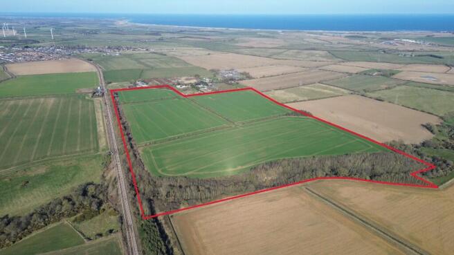
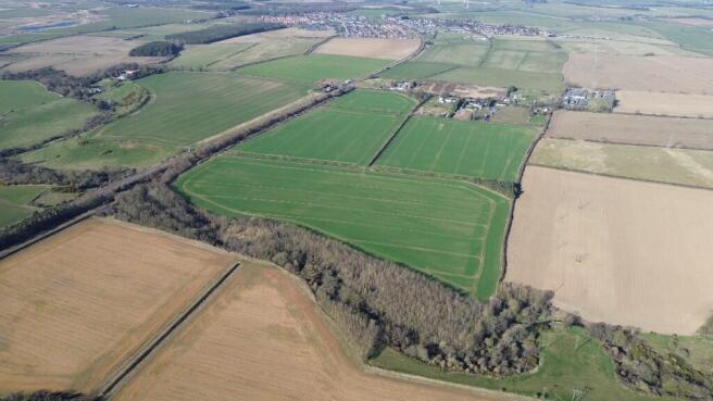
- Block of arable land extending to approximately 64.93 acres (26.28 hectares)
- Bordered by woodland extending to approximately 15.06 acres (6.90 hectares)
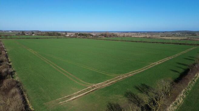
- Readily accessible and accommodating to modern farm machinery
- Capable of producing consistently high yielding combinable crops
Description
It is thought this attractive prospect is to be of interest to a wide range of potential purchasers with the land being well suited and capable of producing consistently high yielding combinable crops.
LOCATION & SITUATION
The land benefits from being well situated, located and accessed directly from the adjacent public highway, less than 2 miles from the nearby village of Ulgham and approximately 6 miles North East from Morpeth. The A1068 Coastal Route is only a short distance away providing a regional link up and down the County.
FARMLAND DESCRIPTION
The land at Ulgham Grange presents an excellent opportunity to acquire an attractive, well portioned block of land. Arranged into four adjoining parcels, the arable land extending to approximately 64.93 acres (26.28 hectares) is bordered by approximately 15.06 acres (6.09 hectares) of woodland, with the River Lyne running to the South of the property. An existing track from the highway ensures the land is readily accessible and accommodating of modern farm machinery, all year round.
Classified as Grade 3 on the Provisional Agricultural Land Classification Map, the versatile land at Ulgham Grange benefits from being farmed and well maintained as part of the Vendors wider arable rotation. It is no surprise that the land is capable of producing consistently high yielding combinable crops.
The sale will be subject to a holdover provision until the 1st October 2025 as the Vendor will retain the right to harvest the growing crop.
The land at Ulgham Grange will be free from any environmental scheme upon completion of the sale, therefore, a desiring purchaser if they wish to do so will have the ability to enter any one of the numerous environmental subsidy schemes available, subject to their status.
CLAWBACK
In the event that planning permission for any renewable energy development is granted on any part of the property, then the Vendor reserves the right to receive a clawback payment of 25% of the uplift in value, for a period of 25 years.
BOUNDARIES
Boundaries are indicated on the sale plan and the responsibility and maintenance for these will be included within the sale in so far as they are owned.
The purchaser shall be deemed to have full knowledge of all boundaries and neither the Vendor nor the selling agents will be responsible for defining the boundaries nor their ownership.
PUBLIC RIGHTS OF WAY
There is a public footpath crossing the land at Ulgham Grange. Full details can be found on the Northumberland County Council definitive public rights of way map.
MINERAL, TIMBER AND SPORTING RIGHTS
All standing and fallen timber will be included within the sale. The mineral rights are excluded from the sale and the sporting rights are included in so far as they are owned.
EASEMENTS AND WAYLEAVES
The land is sold subject to and with the benefit of all rights of way, water, drainage, watercourses and other easements, quasi or reputed easements and rights of adjoining owners (if any) affecting the same and all existing matters registered by any competent authority, subject to Statute.
METHOD OF SALE
The land at Ulgham Grange is registered with the HM Land Registry as Title No. ND92952 and is offered for sale via the method of private treaty, freehold with vacant possession upon completion, subject to the holdover provision until the 1st October 2025. The Vendor reserves the right to conclude the sale as they wish.
LOCAL AUTHORITY
Northumberland County Council
VIEWINGS
Potential purchasers are requested to register their interest at an early stage with the selling agents.
Viewing strictly by prior appointment only.
Please contact selling agent Tom Bell.
Brochures
Land at Ulgham Grange, Morpeth, NE61 3AX

NEAREST STATIONS
Distances are straight line measurements from the centre of the postcode- Widdrington Station1.2 miles
- Ashington Station3.3 miles
- Pegswood Station3.4 miles
About Michie Group LLP, Alnwick
5f Linnet Court Cawledge Business Park, Hawfinch Drive, Lionheart Enterprise Park, Alnwick, NE66 2GDNotes
Disclaimer - Property reference LAUG. The information displayed about this property comprises a property advertisement. Rightmove.co.uk makes no warranty as to the accuracy or completeness of the advertisement or any linked or associated information, and Rightmove has no control over the content. This property advertisement does not constitute property particulars. The information is provided and maintained by Michie Group LLP, Alnwick. Please contact the selling agent or developer directly to obtain any information which may be available under the terms of The Energy Performance of Buildings (Certificates and Inspections) (England and Wales) Regulations 2007 or the Home Report if in relation to a residential property in Scotland.
Map data ©OpenStreetMap contributors.