Ashton Road, Oundle, Peterborough, Northamptonshire

- PROPERTY TYPE
Land
- SIZE
6,009,538 sq ft
558,305 sq m
Description
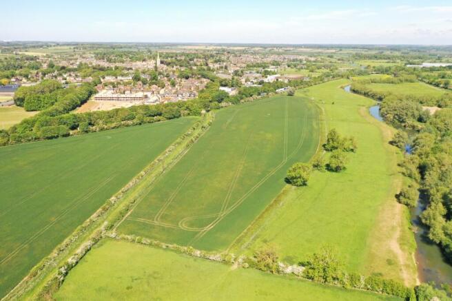
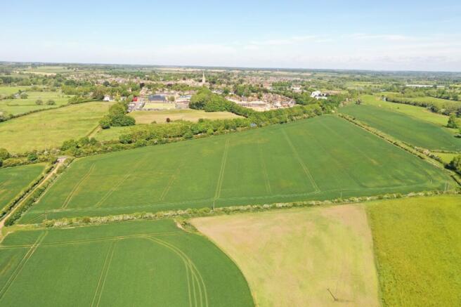
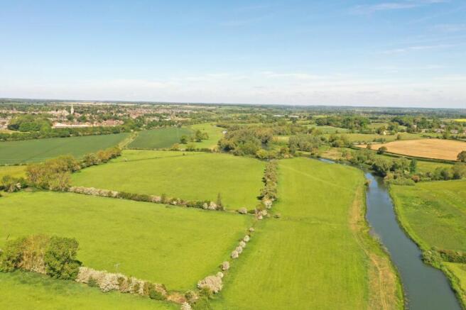
The land at Herne Farm The land is accessed directly from the A605 and internally the parcels can be accessed from a shared right of way over a wide track.
The land is a combination of productive arable land and permanent pasture. In total the land is approximately 137.96 acres (55.86 ha).
General
Method of sale: The Land at Herne Farm is offered for sale as a wholes or in up to five Lots by private treaty.
Subject to licenses and agreements outlined in the brochure. Further details are available from the vendor’s agent.
Services: There are no mains services connected to the property.
Overage: The land is sold subject to an overage on
future non-agricultural development. The overage will not apply to any planning permissions granted or development or use in connection with agriculture, equestrian and forestry activities. If development takes place under the Town and Country Planning (General Permitted Development) (England) Order 2015 Class or any subsequent act or change to the regulations then this will be a trigger event for overage. This overage will be effective for 25 years from the date of completion of the sale and will be
payable on the implementation of planning permission or disposal with planning permission) for such uses (excluding agriculture, forestry or equine use). The amount payable will be 25% of the increase in valueresulting from that consent.
Schemes: The majority of the land is entered into a Mid-Tier Countryside Stewardship scheme with effect from 1st January 2023, for a five year term which is due to expire on 31st December 2027. The options
include; nectar flower mix, legume fallow, winter bird food, management of hedgerows and low input grassland.
The purchaser will be deemed to have full knowledge of the scheme(s) and will take it on and comply with the scheme from completion if necessary. The vendor will retain any Countryside Stewardship payments payable up to completion. Further details are available from the vendor’s agent. The land is also entered into a Sustainable Farming Incentive agreement, which is not transferable on the sale.
Planning: Prospective purchasers are advised that they should make their own enquiries of the local planning authority.
Local Authority: North Northamptonshire Council.
Holdover: Holdover is reserved to permit the harvesting of all growing crops in Lots 2 & 3.
Ingoing valuation: In addition to the purchase price the purchaser will be required to pay for:-
Growing crops and all beneficial cultivations, sub
soiling, moling and acts of husbandry since the last
harvest at current CAAV rates or contract rates where applicable; Seed, fertilisers, manures and sprays applied to the growing crops since the last harvest at invoice cost; All seeds, sprays, fertilisers, fuel, oil and other consumables in store at invoice cost.
Enhancement of £30/ acre/ month from the date of establishment to completion. Lime and chalk applied since the last harvest at invoice cost of the materials and spreading.
Early Entry: Early Entry may be permitted on to fields that have been harvested at the purchasers own risk following exchange of contracts. Further details are available from the vendor’s agent(s).
Sporting, timber and mineral rights: All sporting timber and mineral rights are included in the freehold sale, in so far as they are owned.
Designations: The Farm is in a Nitrate Vulnerable Zone (NVZ).
Drainage Rates: These are charged by the Environment Agency.
Fixtures and fittings: All items usually regarded as tenant’s fixtures and fittings and equipment, including farm machinery, are specifically excluded from the sale.
Guide Price: £1,120,000 for the whole property.
VAT: Any guide price quoted or discussed is exclusive of VAT. In the event that a sale of the property, or any part of it, or any right attached to it, becomes a chargeable supply for the purposes of VAT, such tax will be payable in addition.
Wayleaves, easements and rights of way: The property is being sold subject to and with the benefit of all rights including; rights of way, whether public or private, light, support, drainage, water and electricity supplies and other rights and obligations, easements and quasi-easements and restrictive covenants and all existing and proposed wayleaves for masts, pylons, stays, cables, drains, water and gas and other pipes whether referred to in these particulars or not. There are two public footpaths over Lot 1 and one public footpath over Lot 5. Further details are available from the vendor’s agent.
Health and safety: Given the potential hazards of a working farm we ask you to be as vigilant as possible when making your inspection for your own personal safety, particularly around the farm buildings and machinery.
Solicitors: Spratt Endicott, 52-54 The Green, Banbury
Brochures
Web DetailsParticularsAshton Road, Oundle, Peterborough, Northamptonshire

NEAREST STATIONS
Distances are straight line measurements from the centre of the postcode- Corby Station9.4 miles
About Strutt & Parker, Eastern Estates & Farm Agency - Stamford
5 South View Business Park, Tinwell Road, Stamford, PE9 2JLNotes
Disclaimer - Property reference SFD250012. The information displayed about this property comprises a property advertisement. Rightmove.co.uk makes no warranty as to the accuracy or completeness of the advertisement or any linked or associated information, and Rightmove has no control over the content. This property advertisement does not constitute property particulars. The information is provided and maintained by Strutt & Parker, Eastern Estates & Farm Agency - Stamford. Please contact the selling agent or developer directly to obtain any information which may be available under the terms of The Energy Performance of Buildings (Certificates and Inspections) (England and Wales) Regulations 2007 or the Home Report if in relation to a residential property in Scotland.
Map data ©OpenStreetMap contributors.