
Sutton Mandeville

- PROPERTY TYPE
Land
- SIZE
3,233,894 sq ft
300,439 sq m
Key features
- Easily accessible with the A30 highway 0.6 miles to the south
- Productive Grade 2 arable land
- Stunning, far-reaching southerly views
- A useful timber framed agricultural building
- Good highway access directly off Lagpond Lane
Description
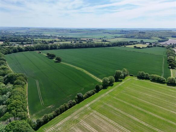
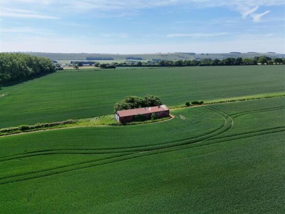
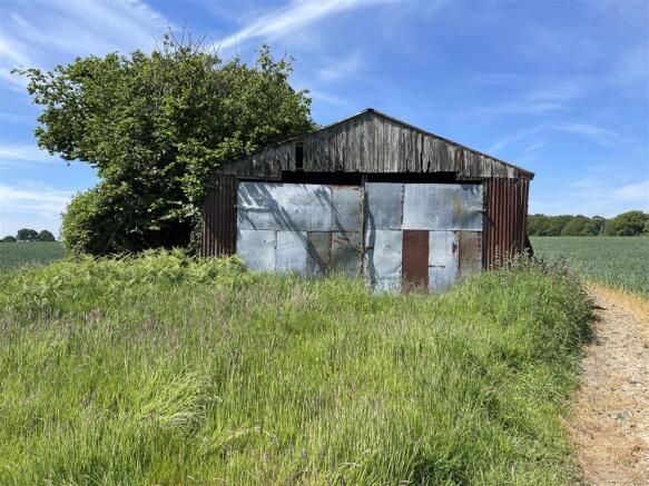
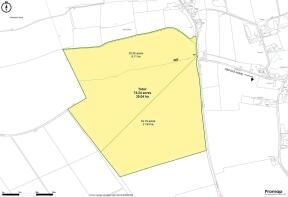
The Property - A conveniently sized block of productive, level and south-facing arable land arranged in two parcels of 54 and 20 acres, with the added provision of a circa 1,200 sqft barn currently used for the storage of machinery. The land benefits from good access off the adjoining unclassified highway Lagpond Lane.
The soil is freely draining loam overlying siltstone and limestone with the entirety being classified as Grade 2 on the ALC map. 2024 cropping was a temporary grass ley cut for silage and this year both parcels are in winter wheat as part of an arable rotation.
Located on the hedgerow which bisects the two parcels is the timber-framed agricultural building. The barn is sited on an earth floor and is comprised of timber-framed elevations and pitched roof, clad with corrugated metal. There is scope to refurbish or replace the building. Approximate dimensions of building: 18.7 ft x 60.4 (5.7m x 18.4m).
Situation - The land is situated in an elevated position just south of the Vale of Wardour and near the quintessential west Wiltshire village of Sutton Mandeville.The A30 which connects Salisbury and Shaftesbury is situated approximately 0.6 miles to the south of the land, facilitating easy access east and west. Lying between 145m & 165m above sea level, the land boasts impressive southerly views toward the chalk escarpment of Swallowcliffe Down, Sutton Down & Buxbury Hill.
Designations - The land is situated in the Cranbourne Chase National Landscape (formerly AONB) and in a groundwater Nitrate Vulnerable Zone.
There are two footpaths which pass through the property - please refer to the sale plan.
Agricultural Schemes - The northern edge of the 20.05 acre parcel is entered into a Mid-Tier Countryside Stewardship agreement ending on 31st December 2025. The option applied is ‘AB8’ which is a flower rich margin or plot. The buyer will be expected to continue with this prescription until the end of the agreement.
Services - There are no services present but we understand mains water and electricity are both nearby.
Title & Possession - Freehold Titles with vacant possession on completion which will take place on 29th September 2025.
Local Authority - Wiltshire Council -
What3words - Entrance: ///gathering.credible.slippery
Viewing - Viewings shall be during daylight hours with a set of sales particulars in hand after informing the agent, contact Will Cairns on .
Brochures
Sales Particulars - Land at Sutton Row.pdfSutton Mandeville

NEAREST STATIONS
Distances are straight line measurements from the centre of the postcode- Tisbury Station2.0 miles

About Symonds & Sampson, Sturminster Newton
Agriculture House, Market Place, Sturminster Newton, DT10 1AR


Notes
Disclaimer - Property reference 33974457. The information displayed about this property comprises a property advertisement. Rightmove.co.uk makes no warranty as to the accuracy or completeness of the advertisement or any linked or associated information, and Rightmove has no control over the content. This property advertisement does not constitute property particulars. The information is provided and maintained by Symonds & Sampson, Sturminster Newton. Please contact the selling agent or developer directly to obtain any information which may be available under the terms of The Energy Performance of Buildings (Certificates and Inspections) (England and Wales) Regulations 2007 or the Home Report if in relation to a residential property in Scotland.
Map data ©OpenStreetMap contributors.