
Land At Walden, West Burton, Leyburn, North Yorkshire, DL8
- PROPERTY TYPE
Land
- SIZE
14,170,939 sq ft
1,316,524 sq m
Key features
- Ring fenced block of moorland and allotment
- Set within the Walden Valley
- Good vehicular access with internal tracks
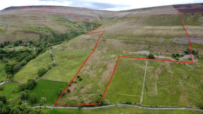
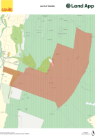
- In all about 325.32 acres
- For sale as a whole
Description
Description
The sale represents a superb opportunity to purchase a ring fenced block of 325.32 acres (133.1 ha) of moorland and allotment, in the scenic Walden Valley south of Wensleydale. The land spectacularly rises from the valley towards the peaks of Penhill, Height of Hazely and Harland Hill.
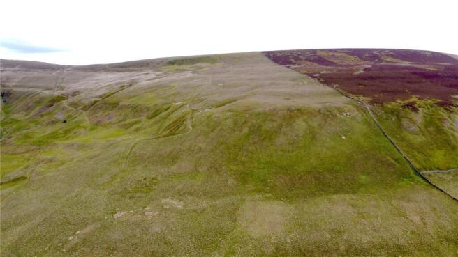
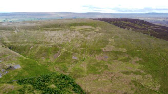
Situated on the eastern flank of Walden Valley, the land sits between 210 and 530 metres above sea level and includes, grassland, bracken, ‘white ground’ allotment land, rocky outcrops, expansive open areas and heather moorland. Adjacent to the land lies significant heather moorland areas falling away to the Yorkshire Dales. The land surrounds and drains steeply into Thupton Gill, about 1 mile south of West Burton village, the watercourse leads to Walden Beck, Bishopdale Beck and ultimately into the River Ure.
The land benefits from direct vehicular access from Whiterow Road (a public highway) and a steep unmade road, known as Thupton Gill Road. There are further internal tracks suitable for small 4x4’s or rough terrain vehicles.
The land lies outside of any Sites of Special Scientific Interest (SSSI), Special Area of Conservation (SAC) or Special Protection Areas (SPA).
The sale offers significant natural capital, amenity, biodiversity, and environmental opportunities, with rare flexibility for such a parcel. Future management could take the form of biodiversity and habitat enhancement, such as heather restoration and where appropriate peatland restoration. In addition the land could offer opportunities for Natural Flood Management and Afforestation.
The majority of the land sits above the moorland line and with a successful heather restoration programme could provide future sporting amenity and enjoyment for a purchaser.
Acreage: 325.32 Acres
Additional Info
Rights of Way, Easements & Wayleaves - The property is sold subject to and with the benefit of all existing wayleaves, easements, and rights of way. A public bridleway crosses the land east to west from the public highway Whiterowe Road, the route runs in part along Thupton Gill Road, climbing steeply to and through the land. It is assumed the land also benefits from a right of way along this track. Please note the track is only suitable for 4x4 vehicles.
Tenure - The freehold of the land is offered for sale with vacant possession on completion.
Services - There is no knowledge of any services connected to the land.
Sporting Rights - The sporting rights are included insofar as they are owned.
Mineral Rights - The mineral rights are included insofar as they are owned.
Grazing Rights - The land is not subject to any third party grazing rights.
Designations - The land lies within the Yorkshire Dales National Park and the majority is designated open access land.
Local Authority - North Yorkshire Council
Planning Authority - Yorkshire Dales National Park Authority
Subsidies and Grants - The land is not entered into any Environmental Stewardship Scheme.
Solicitors - McGarry & Co.
Postcode - DL8 4LG (nearest) Please note the postcode covers a substantial area.
what3words - ///nervy.driveway.sharpened
VAT - The land is not opted to tax, therefore VAT will not be charged.
Method of Sale - The land is offered for sale by private treaty as a whole.
Brochures
Web DetailsLand At Walden, West Burton, Leyburn, North Yorkshire, DL8

NEAREST STATIONS
Distances are straight line measurements from the centre of the postcode- Leyburn Station6.8 miles
Notes
Disclaimer - Property reference YOR250034. The information displayed about this property comprises a property advertisement. Rightmove.co.uk makes no warranty as to the accuracy or completeness of the advertisement or any linked or associated information, and Rightmove has no control over the content. This property advertisement does not constitute property particulars. The information is provided and maintained by Savills Rural Sales, York. Please contact the selling agent or developer directly to obtain any information which may be available under the terms of The Energy Performance of Buildings (Certificates and Inspections) (England and Wales) Regulations 2007 or the Home Report if in relation to a residential property in Scotland.