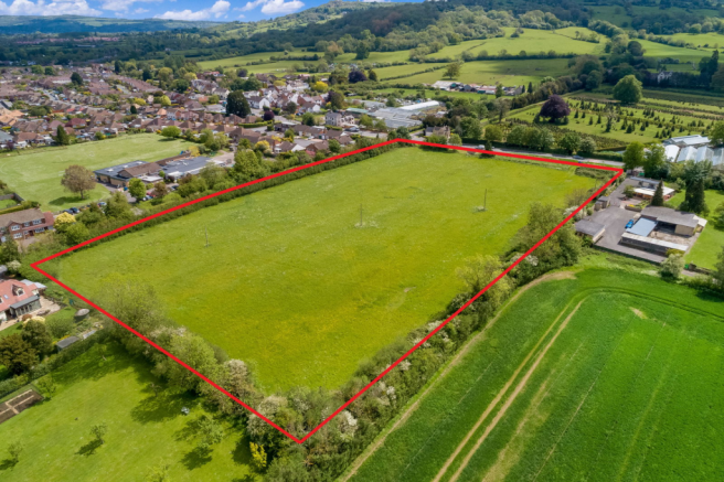
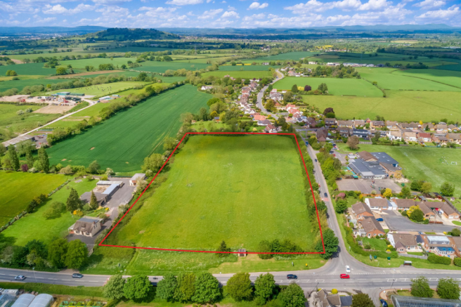
Land Promotion of Land at Shurdington, Badgeworth Lane, Badgeworth, Cheltenham
- PROPERTY TYPE
Residential Development
- SIZE
Ask agent
Key features
- Superb location on the edge of vibrant Gloucestershire village
- Excellent accessibility to the A46/A417 connecting directly to M5 (J.11a North) & M4 (J.15)
- Prime Development Opportunity for high quality residential scheme
- Outline planning application submitted for up to 50 total dwellings plus new access from Badgeworth Lane
- Excellent range of local facilities and amenities, including Primary School well connected to the site
- 50% Affordable Housing provision
- Site Area - approximately 2.29 hectares (5.66 acres)
Description
The development site forms a natural extension to the edge of the existing village settlement, with the site layout featuring a high-quality extensive scheme design that strongly compliments the existing settlement. The site comprises of an open and gently undulating site which benefits from views over open countryside to the south.
New vehicle access will serve the site from Badgeworth Lane, with pedestrian/ cycle crossing proposed on Badgeworth Lane and new pedestrian link onto the footpath adjoining the A46.
Planning
The site is being actively promoted by Richborough and is currently the subject of an outline planning application for a cross-subsidy residential development of up to 50 dwellings (reference 22/01137/OUT). The proposed scheme includes a mix of 50% affordable housing and 10% self/custom build plots, alongside vehicular and pedestrian access, internal streets, drainage infrastructure, landscaping, and associated engineering works. All matters are reserved except for vehicular access, which is proposed onto Badgeworth Lane.
The application was refused by Tewkesbury Borough Council on 18 June 2024 on the basis of green belt policy. Richborough have subsequently appealed the decision to the Planning Inspectorate (Reference APP/G1630/W/24/3357444), arguing that the site now falls within the definition of ‘grey belt’ land under the revised National Planning Policy Framework (NPPF). Tewkesbury Borough Council have since accepted this reclassification. An appeal decision is expected in late summer 2025.
A copy of the planning application documents are contained within the Sale and Technical Pack available in the data room hosted by Richborough.
Key Information
Services: Detailed service enquiries are included in the Sale & Technical Pack. All interested parties should satisfy themselves to the costs of connection for mains services and utilities to the site and rely upon their own enquiries.
Site Investigations: Detailed Site investigation Surveys have been undertaken and are included within the Sale & Technical Pack.
Sale Method: Shurdington Development Site is available For Sale by Informal Tender. Please review the sale and technical pack that accompanies this Brochure for full details of the Tender Process & Tender deadline.
Sale Terms: Tenders are invited on a conditional basis (with the only condition being subject to a JR free planning permission) and invited net of all S.106 Contributions. Tenders must be submitted in accordance with the requirements of the sale and
technical pack and accompanying bid proforma.
Purchaser’s Contribution to Costs: The Buyer is responsible for both the Seller and Promoter’s reasonable legal costs. Upon agreement of Heads of Terms, the successful bidder will be expected to provide an unconditional legal undertaking for £50,000 plus VAT in respect of a contribution towards the Seller’s legal costs.
Marketing Technical Information Pack: A detailed sale pack has been prepared by Richborough. For further information please contact the Selling Agents or Richborough. The Marketing Technical Pack can be found in the Virtual Tour section.
Local Planning Authority: Tewkesbury Borough Council.
VAT: The VAT position is to be confirmed.
Expressions of interest: Interested parties should formally express any interest in the site by emailing confirmation to & melissa.slaney- to ensure that they can be provided with any updates that arise throughout the marketing period. Access to a data room with legal, planning and technical information will be provided on request after an expression of interest is received.
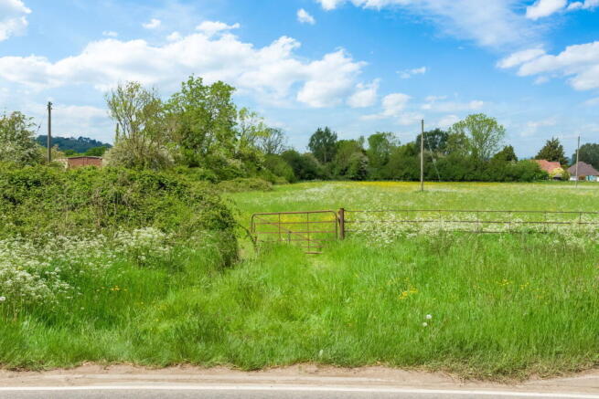
Directions: From the A417 Shurdington junction, head towards Cheltenham along the A46 Bath Road whereby the development site can be found on the left-hand side opposite the entrance to the Greenway Hotel prior to reaching Badgeworth Lane on the left hand side.
Viewings: Access on foot to the development site for viewings is via a field gate on the A46. A pedestrian walkway opposite Shurdington Primary School leads on the A46. It is advised that vehicles are best parked on the Badgeworth Lane rather than in the field gateway.
Site Promoter: The outline planning consent to be secured upon the development site has been submitted by national Promoter, Richborough Estates
For further information please contact or Stuart Leaver BSc (Hons) MSc MRICS FAAV or David Powell BSc (Hons) MSc MRICS FAAV on or email . Queries in respect of the Richborough Technical Pack can be made to Melissa Slaney-Smith on melissa.slaney- or .
Brochures
Brochure 1Land Promotion of Land at Shurdington, Badgeworth Lane, Badgeworth, Cheltenham

NEAREST STATIONS
Distances are straight line measurements from the centre of the postcode- Cheltenham Spa Station2.6 miles
- Gloucester Station5.0 miles
Notes
Disclaimer - Property reference S1364854. The information displayed about this property comprises a property advertisement. Rightmove.co.uk makes no warranty as to the accuracy or completeness of the advertisement or any linked or associated information, and Rightmove has no control over the content. This property advertisement does not constitute property particulars. The information is provided and maintained by Powells, Monmouth. Please contact the selling agent or developer directly to obtain any information which may be available under the terms of The Energy Performance of Buildings (Certificates and Inspections) (England and Wales) Regulations 2007 or the Home Report if in relation to a residential property in Scotland.
Map data ©OpenStreetMap contributors.