109 Acres of Arable Land, Gayton le Marsh
- PROPERTY TYPE
Farm Land
- SIZE
Ask agent

Description
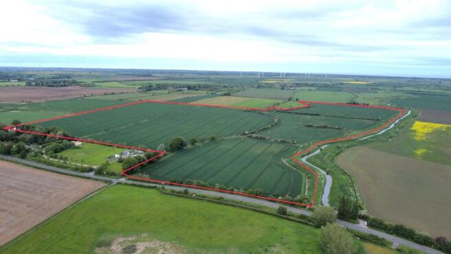
The land has been well farmed and maintained and is currently growing a clean crop of Winter Wheat. It benefits from being ringfenced and has road frontage access to part. It is a particularly attractive block of land which adjoins the River Eau.
The land is being offered for sale by private treaty with full vacant possession upon completion.
Guide Price: £900,000
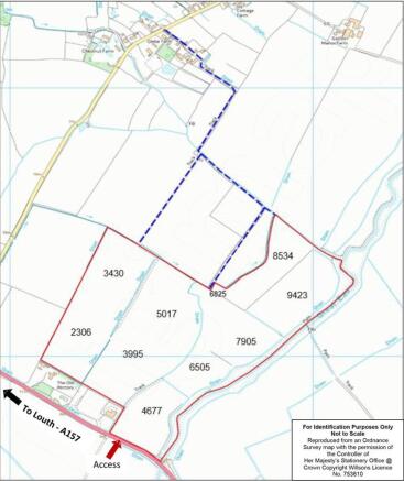
Location And Access - The land is situated off Louth Road (A157) in the parish of Gayton le Marsh, Lincolnshire.
The land has direct road frontage from Louth Road and is also accessed via Poor Plat Lane as dashed blue on the attached plan (the sellers will provide a statement to confirm use over the tracks for the family’s period of ownership).
What3words Location: severe.dabble.crunches
Tenure & Possession - The Freehold interest in the land is being offered for sale with full vacant possession upon completion, subject to the clearance of the current growing crop of Winter Wheat.
Grade, Soil Type & Topography - The land is scheduled as Grade 3 by the Agricultural Land Classification of England and Wales and the land is largely level lying, with a slight rise from south to north.
The soil type as defined by the Soil Survey of England and Wales is “Wallasea 2” and “Holderness”.
Rural Payments Agency - All of the land is registered with the Rural Payments Agency, however, there are no Basic Payment Scheme Entitlements included in the sale as they are no longer transferable.
Boundaries - The land is clearly demarcated by boundary features, being predominantly hedges and ditches. The purchaser is deemed to have full knowledge of all boundaries and neither the vendor nor the selling agent will be responsible for defining the boundaries nor their ownership.
Services - We are not aware that the land has the benefit of any mains services being connected.
Underdrainage - We understand that some of the land has been underdrained in the past, no underdrainage plans are available.
Outgoings & Nitrogen Vulnerable Zone - Annual drainage rates are payable to the Environment Agency and Lindsey Marsh Internal Drainage Board. The land lies within a Surface Water Nitrogen Vulnerable Zone - SWSGZ1002.
Sporting, Timber & Mineral Rights - Sporting, timber and mineral rights are included in the sale insofar as they are owned, subject to statutory exclusions.
Easements, Wayleaves & Rights Of Way - The only known easement effecting the land are overhead electricity cables and poles crossing parcel nos. 2306 & 3430. There is a public footpath which follows the northern boundary of the land.
We are not aware of any other rights which affect the land. All of the land is sold subject to and with the help and benefit of all existing rights, including rights of way whether public or private, light, support, drainage, water and electricity supplies and other rights, easements, and all wayleaves whether referred to or not in these particulars.
Plans, Areas & Schedules - These have been prepared as accurately as possible and are based on Ordnance Survey Plans and the Rural Land Register maps and although believed to be correct are for guidance and identification purposes only.
Viewing - These particulars constitute a permit to view the land at any reasonable time of day, however, the land is currently growing a crop of Winter Wheat and we ask that you are respectful of the tenant’s current growing crop. Neither the vendor, agent or tenant accept any responsibility for any loss, harm or injury which may occur whilst upon the land and you enter entirely at your own risk.
Vat - It is understood that the sale will not attract VAT, however, in the event that any of the property is sold subject to VAT, this will be payable in addition to the purchase price.
Anti Money Laundering - In accordance with the most recent Anti Money Laundering legislation the purchaser will be required to provide proof of identity and proof of funds to the selling agent once an offer has been submitted and accepted (subject to contract) prior to solicitors being instructed.
Local Authorities - Lincolnshire County Council, Newlands, Lincoln, LN1 1YW - Tel:
East Lindsey District Council, The Hub, Mareham Road, Horncastle, Lincolnshire,
LN9 6PH - Tel:
Environment Agency, Ceres House, Searby Road, Lincoln, LN2 4DW
Tel:
Vendor’S Solicitor - Wilkin Chapman, Oxley House, Lincoln Way, Louth, Lincolnshire, LN11 0LS
Schedule Of Areas & Previous Cropping - Please see attached Particulars of Sale.
Brochures
109 Acres of Arable Land at Gayton le Marsh - 01.0Brochure109 Acres of Arable Land, Gayton le Marsh

NEAREST STATIONS
Distances are straight line measurements from the centre of the postcode- Thorpe Culvert Station14.1 miles


Notes
Disclaimer - Property reference 34017365. The information displayed about this property comprises a property advertisement. Rightmove.co.uk makes no warranty as to the accuracy or completeness of the advertisement or any linked or associated information, and Rightmove has no control over the content. This property advertisement does not constitute property particulars. The information is provided and maintained by Willsons, Alford. Please contact the selling agent or developer directly to obtain any information which may be available under the terms of The Energy Performance of Buildings (Certificates and Inspections) (England and Wales) Regulations 2007 or the Home Report if in relation to a residential property in Scotland.
Map data ©OpenStreetMap contributors.