Swanmore, SO32

- PROPERTY TYPE
Land
- SIZE
99,752 sq ft
9,267 sq m
Key features
- SEE AND PRINT PDF SALES PARTICULARS AVAILABLE BELOW
- SEE DRONE VIDEO FOOTAGE ON THE VIRTUAL TOUR TAB
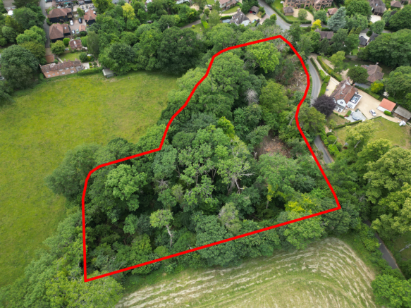
- APPROX. 2.29 ACRES
- ATTRACTIVE LOCATION CLOSE TO SWANMORE
- BROADLEAF WOODLAND IN FORMER CLAYPIT
- ACCESS OFF HAMPTON HILL
- RECENT ASH DIEBACK MANAGEMENT
- SUITABLE FOR AMENITY, FORESTRY, RECREATION AND CONSERVATION
Description
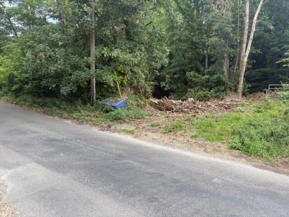
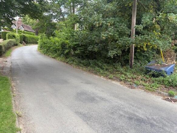
VIEWING INSTRUCTIONS: On foot unaccompanied and only during daylight hours, taking a set of these Sales Particulars with you. Access from south-western corner of Property, as indicated on Site Plan.
DESCRIPTION: The Property extends in all to approx. 2.29 acres (0.92 Ha) of broadleaf woodland with established ground flora. The "bowl-like" shape of the land, along with designation of the site within Hampshire Minerals and Waste Plan as an area where there is brick clay, suggests that the Property may be a former clay pit with the clay likely used to make bricks for local houses.
Recent management of the woodland has resulted in deadwood on the ground, which will in time provide an excellent habitat for local species. On the boundaries there are steep banks with post and wire fencing at the top in places. The Property lends itself to recreation, conservation and amenity uses being conveniently located close to the village of Swanmore. This is subject to obtaining planning consent where required.
ACCESS: Access is currently on foot via the points marked by arrow on the Site Plan. Recent tree works have created a natural trackway through the property. Historically there was a structure situated close to the access (marked "S" on the Site Plan) and a footprint still remains. If sufficiently cleared, there is the possibility that a vehicle could be parked in this location.
LAND REGISTRY: The woodland comprises the entirety of Land Registry Title HP662021. Copy available to view on the Selling Agent's website.
DESIGNATIONS: The Property is situated within the South Downs National Park and within the South Hampshire Lowlands National Character Area. It is not designated Ancient Woodland and no Tree Protection Orders have been identified on the Property. No other significant environmental or planning designations have been identified as affecting the Property.
PLANNING: There are no recent planning applications affecting the Property. The Property is located outside settlement boundaries in an area designated as Countryside under the South Downs Local Plan.
PUBLIC RIGHTS OF WAY: There are no public rights of way directly affecting the Property.
OTHER RIGHTS: By Agreement dated 19th May 2005, the owners of the residential property to the north (Donigers) historically benefitted from a right to drain to a cesspit located approximately at the position marked X on the Site Plan. As the residential property now has a septic tank within its curtilage, it is believed that this Agreement has now been terminated. Copy available to view on the Selling Agent's website.
DEVELOPMENT OVERAGE: The Vendors are mindful to retain a 30% share of any uplift in value caused by Planning Consent for any residential or commercial development on the Property during a period of 25 years from the completion date of the sale.
SERVICES: No services currently connected. Given the proximity to residential properties it is likely that services are available nearby.
RECENT ASH DIEBACK MANAGEMENT: Following correspondence with Winchester City Council, recent work has been undertaken to fell the ash trees from the woodland that were dead and dying, as a result of Ash Dieback Disease. This disease is now widespread and is killing a high percentage of Ash trees across the UK. See Link from the Woodland Trust, giving further information about the disease, available on the Sales Particulars on the Agents website. Much of the felled timber has been left in place for the development of wildlife habitat and biodiversity.
LOCAL AUTHORITY: Winchester City Council (WCC), City Offices, Colebrook Street, Winchester, Hampshire, SO23 9LJ.
PLANNING AUTHORITY: South Downs National Park (SDNP), South Downs Centre, North Street, Midhurst, West Sussex, GU29 9DH.
Brochures
Sales ParticularsSwanmore, SO32

NEAREST STATIONS
Distances are straight line measurements from the centre of the postcode- Botley Station4.0 miles
- Swanwick Station6.2 miles
About Giles Wheeler-Bennett, Southampton
West Court, Lower Basingwell Street, Bishop's Waltham, SO32 1AJ
Notes
Disclaimer - Property reference Donigers. The information displayed about this property comprises a property advertisement. Rightmove.co.uk makes no warranty as to the accuracy or completeness of the advertisement or any linked or associated information, and Rightmove has no control over the content. This property advertisement does not constitute property particulars. The information is provided and maintained by Giles Wheeler-Bennett, Southampton. Please contact the selling agent or developer directly to obtain any information which may be available under the terms of The Energy Performance of Buildings (Certificates and Inspections) (England and Wales) Regulations 2007 or the Home Report if in relation to a residential property in Scotland.
Map data ©OpenStreetMap contributors.