
Tupps Field, Passfield Road, GU30 7RU
- PROPERTY TYPE
Farm Land
- SIZE
724,838 sq ft
67,340 sq m
Key features
- SEE AND PRINT PDF SALES PARTICULARS AVAILABLE BELOW
- SEE DRONE VIDEO FOOTAGE ON THE VIRTUAL TOUR TAB
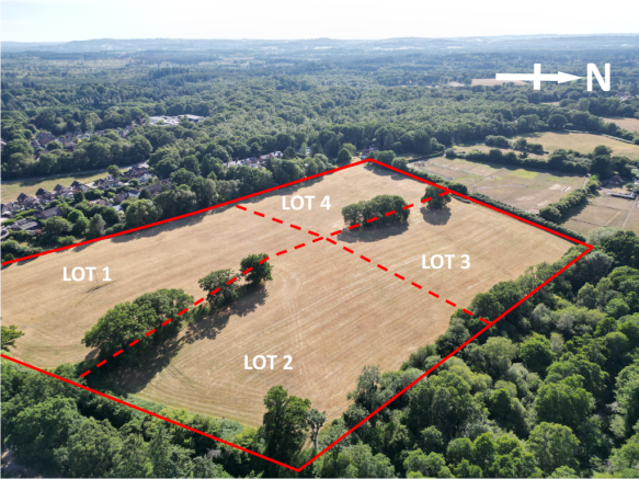
- EXTENDS IN ALL TO APPROX. 16.64 ACRES
- AVAILABLE AS A WHOLE OR IN UP TO 4 LOTS
- AGRICULTURAL PASTURE LAND
- ROAD FRONTAGE
- 3 ACCESS POINTS
- SERVICES AVAILABLE
- UNACCOMPANIED VIEWING AVAILABLE - PLEASE READ SALES PARTICULARS
- PARTS REASONABLY LEVEL AND OTHER PARTS GENTLY SLOPING
Description
VIDEO DRONE FOOTAGE: See Selling Agent's website for further details, photographs and drone video footage is available showing the whole Property.
LOCATION: See Location Plans 1 and 2. What3Words: 7RU.
DIRECTIONS: At Passfield at the B3004 road between Bordon and Liphook turn onto Passfield Road heading northwards and the land is on your left hand side after only approx. 200 yards, with 2 entrance gates off Passifleld Road.
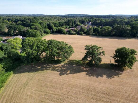
DESCRIPTION: The Property extends in all to approx. 16.64 acres (6.73 Ha) as outlined red on the Site Plan. The land has historically been in pasture for many years and the grass crop being harvested annually and removed from the land. There are no buildings on the land.
LAND REGISTRY: The Property is registered under Title Number HP543766. See Selling Agent's website for Title Plan extract and Register.
The land is available either as a whole in up to 4 Lots. See Site Plan.
Lot 1 - Approx. 5.91 acres with access and road frontage.
Lot 2 - Approx. 3.40 acres with access and road frontage.
Lot 3 - Approx. 3.33 acres. Access route will be via Lot 2.
Lot 4 - Approx. 4.00 acres with 1 access point, or via Lot 1.
It may be possible for neighbouring properties, or parties close by, to express interest and submit offers for smaller parcels. These will need to be identified on a copy of our Site Plan and dimensions added and sent to the Selling Agent.
LAND: The Geological Survey Plan indicates the geology to be 'Cretaceous and Tertiary sand' - with soil and site characteristics being: Well drained very acid sandy soils with a bleached subsurface horizon. Some similar soils with slowly permeable subsoils and slight seasonal waterlogging. Some sandy and coarse loamy soils affected by groundwater often with humose surface horizon. The Land is Agricultural Land Classification Grade 4. The land lies approx. 80m above sea level.
PLANNING HISTORY: There is no history of any Planning Applications on the land. In 2018-2020 the land was being considered for SANGS (Site of Alternative Natural Green Space) to serve a nearby proposed residential development, but that did not proceed.
PLANNING STATUS: Countryside. The land is outside of the South Downs National Park.
TPOs: There are no Tree Preservation Orders that affect the Property.
ACCESS: The Property benefits from 3 vehicular access points as identified by arrows on the Site Plan. 2 of these are directly off Petersfield Road at either end of the road frontage which forms the eastern boundary. The third access is over a track between the neighbouring residential properties adjoining the southern boundary. PLEASE DO NOT ACCESS THIRD ACCESS POINT WHEN VIEWING. Please speak to the Selling Agent for more details.
DESIGNATIONS: The site is within 400m of the Wealden Heaths Phase II - Special Protection Area and Woolmer Forest Special Area of Conservation.
SERVICES: None connected but mains Water and Electricity are close by and available. Interested parties must make their own enquiries to the relevant utility provider.
WAYLEAVES: An 11kv overhead electricity line on wooden poles crosses the Property. A 33kv overhead electricity line on wooden poles cross just inside the Property.
DEVELOPMENT UPLIFT: Subject to the level of any offers, the Vendors are mindful to retain a 25% share of any revenue achieved for Natural Capital Schemes (including BNG) or residential type development over a 50 year period. Please discuss this further with the Selling Agent.
LOCAL AUTHORITY: East Hampshire District Council, (EHDC), Penns Place, Petersfield GU31 4EX.
Brochures
Sales ParticularsTupps Field, Passfield Road, GU30 7RU

NEAREST STATIONS
Distances are straight line measurements from the centre of the postcode- Liphook Station2.2 miles
- Haslemere Station4.8 miles
- Liss Station4.7 miles
About Giles Wheeler-Bennett, Southampton
West Court, Lower Basingwell Street, Bishop's Waltham, SO32 1AJ
Notes
Disclaimer - Property reference TuppsWhole. The information displayed about this property comprises a property advertisement. Rightmove.co.uk makes no warranty as to the accuracy or completeness of the advertisement or any linked or associated information, and Rightmove has no control over the content. This property advertisement does not constitute property particulars. The information is provided and maintained by Giles Wheeler-Bennett, Southampton. Please contact the selling agent or developer directly to obtain any information which may be available under the terms of The Energy Performance of Buildings (Certificates and Inspections) (England and Wales) Regulations 2007 or the Home Report if in relation to a residential property in Scotland.