Building with Class Q Residential Consent, Newtown, PO17

- PROPERTY TYPE
Detached
- BEDROOMS
5
- SIZE
4,891 sq ft
454 sq m
- TENUREDescribes how you own a property. There are different types of tenure - freehold, leasehold, and commonhold.Read more about tenure in our glossary page.
Freehold
Key features
- SEE AND PRINT PDF SALES PARTICULARS AVAILABLE BELOW
- SEE DRONE VIDEO FOOTAGE ON THE VIRTUAL TOUR TAB
- DEVELOPMENT OPPORTUNITY
- PERMITTED DEVELOPMENT - CLASS Q RESIDENTIAL CONSENT (APPROX. 4,891 sq. ft.)
- SET WITHIN A CURTILAGE OF APPROX. 1 ACRES (0.40 HA)
- OPPORTUNITY TO ACQUIRE FURTHER LAND UP TO 17.22 ACRES (6.97 HA)
- ACCESS FROM LIBERTY ROAD
- ATTRACTIVE RURAL SETTING AND VIEWS OVER PASTURE FIELDS
- ADJACENT TO THE FOREST OF BERE
- IN THE MEON VALLEY, CLOSE TO THE SOUTH DOWNS NATIONAL PARK
Description
The property is located off Liberty Road, Newtown approximately 3 miles from the picturesque market town of Wickham, with its range of local amenities. There are a number of state and independent schools within easy reach, including Newtown Infant School and Swanmore College. The A32 to the west provides access to the M27 at Junction 10, which in turn connects to the M3 and A3. The railway stations at Botley, Petersfield and Winchester provide direct train services to London Waterloo.
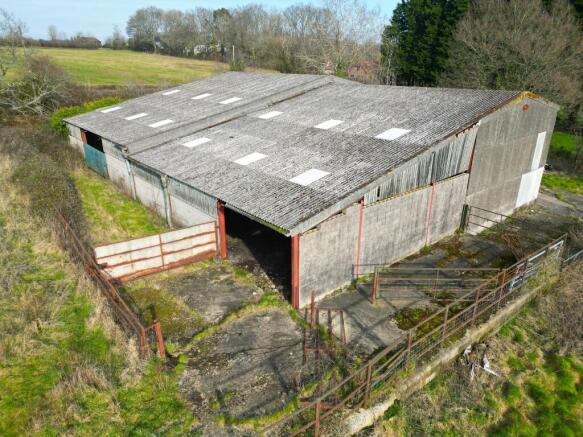
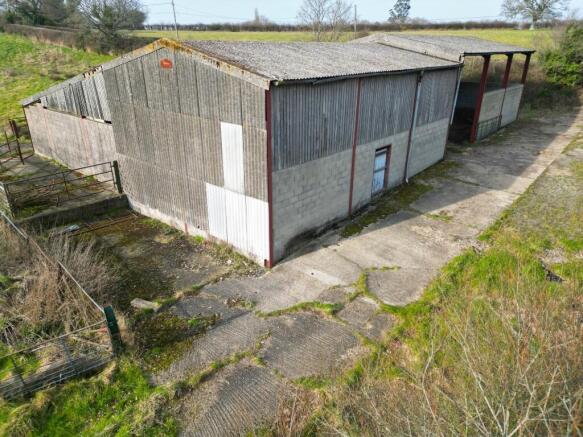
DESCRIPTION: The property includes an agricultural building benefitting from a planning consent to convert to a residential dwelling. The building itself is a conventional steel-portal framed agricultural building extending to approx. 545 sq. m/5,866 sq. ft. with lower walls of concrete block and upper walls a mix of vertical slatted timber boarding and corrugated sheeting. The roof is constructed of corrugated fibre sheeting. There are three metal stock gate openings to the West and North elevations. A vehicular access and a pedestrian door are located in the East elevation.
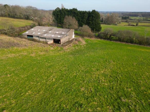
The land included with the building extends to approx. 1 acre (0.40 ha), as coloured pink on the Site Plan. There is concrete hardstanding on the East side of the building extending from the access to Liberty Road. The hardstanding stretches around much of the perimeter of the building. The building is in a very attractive rural setting and the proposed new dwelling, being on higher ground with a southerly aspect, would benefit from views over the pasture fields. Approximately 175m to the west is the Forest of Bere which forms the edge of the South Downs National Park.
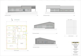
CLASS Q - PLANNING CONSENT: By planning consent 24/01077/PNACOU dated 11th July 2024, permission has been granted for the conversion of the agricultural building to a residential dwelling with a gross internal floorspace of approx. 4891 sq. ft. (454.39 sq, m). The planning consent states that the development permitted must be begun before the expiration of three years from the date of permission. The approved Floorplan/elevations, Structural Assessment and Decision Notice are available on the Selling Agent's website. Full details of the application can be obtained via the Winchester local planning website- 24/01077/PNACOU.
ADDITIONAL LAND: There is an additional approx. 17.22 acres (6.97 ha) of adjacent land available in two Lots, as shaded green (Lot 2 - 3.12 acres) and blue (Lot 3 - 14.10 acres) on the Site Plan. This land is available only with Lot 1 which is shaded pink and labelled Lot 1 on the Site Plan. This additional land is currently in use as agricultural pastureland for hay production.
RIGHT OF WAY: A right of way at all times and for all purposes with or without vehicles will be retained for the benefit of the Vendor's retained land over Lot 3. This right of way will commence at the new access from Liberty Road approved by planning consent 24/02126/FUL dated 13th January 2025. Full details of the consent can be obtained via the Winchester local planning website 24/02126/FUL and a copy of the Decision Notice and Proposed Access Plan is available on the Selling Agent's website. The approximate route of this right of way (5m wide) is shown by the yellow hatching on the Site Plan. As the planning consent has not yet been implemented, the Vendor will also retain the right to construct this new access from Liberty Road, including discharging the conditions on the planning decision notice.
LAND REGISTRY: The property comprises part of Land Registry Title HP389336. Copy of Land Registry Title Plan and Register available on the Selling Agent's website.
PLANNING: The property is within the Winchester City Council planning area and the Adopted Local Plan shows the land to be 'countryside'. Recent planning applications include the application for Prior Approval under Class Q Permitted Development Rights for the conversion of the agricultural building within Lot 1 to a residential dwelling (24/01077/PNACOU) granted consent on 11th July 2024. Also the planning application for a new access from Liberty Road (24/02126/FUL) affecting Lot 3 granted consent on 13th January 2025.
DESIGNATIONS: The property is situated outside the South Downs National Park and within the South Hampshire Lowlands National Character area. No other significant environmental designations have been identified. The South Down National Park boundary is adjacent to the western boundary of Lot 3.
PUBLIC RIGHTS OF WAY: No public rights of way cross the Property.
PORTSMOUTH WATER EASEMENT: By Deed dated 14th November 2007, a 5m easement was granted allowing Portsmouth Water to lay and maintain a water main close to the western boundary adjacent to the Forest of Bere. This affects Lot 3 only. Copy of Deed and Plan available on the Selling Agent's website.
FOREST OF BERE: The property benefits from proximity to the historic Forest of Bere which is adjacent to the western boundary of Lot 3. This provides a range of opportunities for walking, horse riding and cycling.
JAPANESE KNOTWEED: An area of Japanese Knotweed has been identified on the property against the ditch to the east of the building. The location of this is marked on the Site Plan. The Knotweed growth is currently being treated under an active and fully paid for Knotweed management plan with a guarantee period until 30th June 2034 against regrowth. See Selling Agent's Website for Copy of Knotweed Management Plan and Guarantee Certificate.
COMMUNITY INFRASTRUCTURE LEVY (CIL): By letter dated for 12th July 2024, Winchester City Council have confirmed that development of the building in accordance with planning consent 24/01077/PNACOU would be exempt from CIL. Copy of Letter available on the Selling Agent's website.
SERVICES: Water is currently connected to troughs on Lots 2 and 3. Electricity was previously connected to the building but is not currently. A quote has been obtained for reconnecting the electricity supply. See Selling Agent's Website for Copy of Quote and Plan.
LOCAL AUTHORITY: Winchester City Council, City Offices, Colebrook Street, Winchester SO23 9LJ. Tel: .
OFFER INSTRUCTIONS: Please see the Additional Document on the Agent's website for instructions, as to how to make an offer by Private Treaty.
Brochures
Sales Particulars- COUNCIL TAXA payment made to your local authority in order to pay for local services like schools, libraries, and refuse collection. The amount you pay depends on the value of the property.Read more about council Tax in our glossary page.
- Ask agent
- PARKINGDetails of how and where vehicles can be parked, and any associated costs.Read more about parking in our glossary page.
- Ask agent
- GARDENA property has access to an outdoor space, which could be private or shared.
- Ask agent
- ACCESSIBILITYHow a property has been adapted to meet the needs of vulnerable or disabled individuals.Read more about accessibility in our glossary page.
- Ask agent
Energy performance certificate - ask agent
Building with Class Q Residential Consent, Newtown, PO17

Add an important place to see how long it'd take to get there from our property listings.
__mins driving to your place
Get an instant, personalised result:
- Show sellers you’re serious
- Secure viewings faster with agents
- No impact on your credit score
About Giles Wheeler-Bennett, Southampton
West Court, Lower Basingwell Street, Bishop's Waltham, SO32 1AJ
Your mortgage
Notes
Staying secure when looking for property
Ensure you're up to date with our latest advice on how to avoid fraud or scams when looking for property online.
Visit our security centre to find out moreDisclaimer - Property reference ClassQLiberty. The information displayed about this property comprises a property advertisement. Rightmove.co.uk makes no warranty as to the accuracy or completeness of the advertisement or any linked or associated information, and Rightmove has no control over the content. This property advertisement does not constitute property particulars. The information is provided and maintained by Giles Wheeler-Bennett, Southampton. Please contact the selling agent or developer directly to obtain any information which may be available under the terms of The Energy Performance of Buildings (Certificates and Inspections) (England and Wales) Regulations 2007 or the Home Report if in relation to a residential property in Scotland.
*This is the average speed from the provider with the fastest broadband package available at this postcode. The average speed displayed is based on the download speeds of at least 50% of customers at peak time (8pm to 10pm). Fibre/cable services at the postcode are subject to availability and may differ between properties within a postcode. Speeds can be affected by a range of technical and environmental factors. The speed at the property may be lower than that listed above. You can check the estimated speed and confirm availability to a property prior to purchasing on the broadband provider's website. Providers may increase charges. The information is provided and maintained by Decision Technologies Limited. **This is indicative only and based on a 2-person household with multiple devices and simultaneous usage. Broadband performance is affected by multiple factors including number of occupants and devices, simultaneous usage, router range etc. For more information speak to your broadband provider.
Map data ©OpenStreetMap contributors.