
Briantspuddle, Dorchester, Dorset, DT2
- PROPERTY TYPE
Equestrian Facility
- SIZE
Ask agent
- TENUREDescribes how you own a property. There are different types of tenure - freehold, leasehold, and commonhold.Read more about tenure in our glossary page.
Freehold
Key features
- Versatile paddock
- Village location
- Mains water connection
- Useful outbuildings
Description
** Overage now removed **
LOCATION
The paddock enjoys a peaceful, rural setting in the picturesque village of Briantspuddle. Located at the heart of the Piddle Valley, the village forms part of the Affpuddle and Turnerspuddle civil parish. Lying close to the River Piddle, a well-preserved chalk stream, Briantspuddle was originally the centrepiece of the Debenham Estate owned by the famous retailing family of the same name. Briantspuddle lies a short distance to the north of the Purbeck Hills National Landscape and close to the World Heritage Site of the Jurassic Coast.
The land is conveniently located from the quiet country lane continuing to Throop and approached from the south over a right of access, with the County Town of Dorchester being 10.10 miles west, and Blandford Forum being 16.60 miles north. Situated in a private position, the paddock is neighboured by residential gardens to the south, and far-reaching views of the agricultural land to the remaining surround.
DESCRIPTION
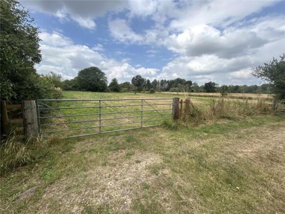
This sale presents the unique opportunity to acquire a paddock extending to approximately 2.13 acres (0.86ha) of level lying pastureland historically used for agricultural, and equestrian grazing; the land benefits from miles of nearby bridleways crossing the Piddle Valley. The paddock is accessed via a right of access to the south, as shaded brown on the attached Site Plan.
This single enclosure is predominately registered as Grade III on the Post-1988 Agricultural Land Classification Maps of England, with an area to the north-east comprising Grade IV. The land contains freely draining slightly acid loamy soils with low fertility ratings. The land is enclosed by a combination of post and sheep netting and secured with a 6-bar galvanised gate.
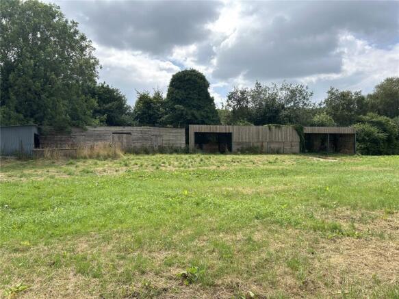
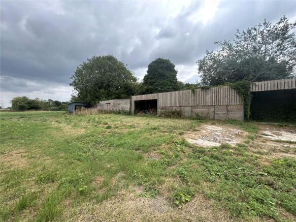
As shaded red on the attached Site Plan, this sale also includes a number of useful outbuildings to the southern boundary; to include an 8-bay steel portal, timber cladded barn, timber storage barn and cladded shelter with concrete frontage. This versatile paddock lends itself to be ideally suitable for agricultural, equestrian, or other amenity uses subject to the necessary planning consents.
ACCESS
The paddock is accessed via the galvanised gateway to the southeast, with a right of access over the lane as shaded brown on the attached site plan.
SERVICES
The land benefits from mains water.
AGRI-ENVIRONMENTAL SCHEMES
The land is not subject to any Environmental Land Management Schemes.
BASIC PAYMENT SCHEMES
No delinked payments are attached to the land or included in the sale.
TENURE
Freehold available upon completion with vacant possession.
** Overage now removed **
LOTTING
It is anticipated that the property will be offered as lotted, but the Vendor reserves the right to sell the property as a whole or in lots privately or to amalgamate, withdraw, sub-divide, alter, add to or amend any lot or any part prior to the sale. No responsibility can be accepted for any expenses incurred by intending purchasers inspecting properties which have been sold, let or withdrawn.
STATUTORY DESIGNTAIONS
The land is located in the Nitrate Vulnerable Zone.
AGENTS NOTE
The land and outbuildings will be sold as seen and there is to be no vehicular access when
viewing.
RIGHTS OF WAY, EASEMENTS, ETC
The land, as far as required by the Vendors, will be conveyed, subject to all other private rights of way, easements, and wayleaves of telegraph and telephone poles, stays and wires, electric pylons, poles and cables, water and gas pipes at present erected on and passing over or under the property and subject to the agreements affecting the same (if any).
TOWN & COUNTRY PLANNING
The land, is sold subject to any Development Plan, Tree Preservation Order, Town Planning Schedule, Resolution or Notice which may be or which may come to be in force, and also subject to any statutory provision of byelaws without any obligation on the part of the Vendors to specify them and the Purchaser shall be deemed to have full knowledge of and to satisfy themselves about the provisions of any such matter affecting the property.
OUTGOINGS
The property is sold and as far as is required by the Vendor will be conveyed subject to all rights of way, easements and wayleaves of telegraph and telephone poles, stays and wires, electricity pylons, poles and cables, water and gas pipes at present erected on the passing over or under the property and subject to the agreement effecting the same (if any).
FARM PROPERTIES HEALTH & SAFETY NOTICE
All persons wishing to view the property do so at their own risk. Neither the Vendor nor Agents will be held liable for any damage or injury that may occur when interested parties are visiting the property. The land and outbuildings are potentially a hazardous environment and for prospective purchasers own personal safety, please be vigilant.
DIRECTIONS/WHAT.3.WORDS
///preheated.recording.feels
Brochures
Particulars- COUNCIL TAXA payment made to your local authority in order to pay for local services like schools, libraries, and refuse collection. The amount you pay depends on the value of the property.Read more about council Tax in our glossary page.
- Band: TBC
- PARKINGDetails of how and where vehicles can be parked, and any associated costs.Read more about parking in our glossary page.
- Ask agent
- GARDENA property has access to an outdoor space, which could be private or shared.
- Yes
- ACCESSIBILITYHow a property has been adapted to meet the needs of vulnerable or disabled individuals.Read more about accessibility in our glossary page.
- Ask agent
Energy performance certificate - ask agent
Briantspuddle, Dorchester, Dorset, DT2

Add an important place to see how long it'd take to get there from our property listings.
__mins driving to your place
Get an instant, personalised result:
- Show sellers you’re serious
- Secure viewings faster with agents
- No impact on your credit score
About Greenslade Taylor Hunt, Dorchester
45 High West Street, Dorchester, DT1 1UT


Your mortgage
Notes
Staying secure when looking for property
Ensure you're up to date with our latest advice on how to avoid fraud or scams when looking for property online.
Visit our security centre to find out moreDisclaimer - Property reference DOA250024. The information displayed about this property comprises a property advertisement. Rightmove.co.uk makes no warranty as to the accuracy or completeness of the advertisement or any linked or associated information, and Rightmove has no control over the content. This property advertisement does not constitute property particulars. The information is provided and maintained by Greenslade Taylor Hunt, Dorchester. Please contact the selling agent or developer directly to obtain any information which may be available under the terms of The Energy Performance of Buildings (Certificates and Inspections) (England and Wales) Regulations 2007 or the Home Report if in relation to a residential property in Scotland.
*This is the average speed from the provider with the fastest broadband package available at this postcode. The average speed displayed is based on the download speeds of at least 50% of customers at peak time (8pm to 10pm). Fibre/cable services at the postcode are subject to availability and may differ between properties within a postcode. Speeds can be affected by a range of technical and environmental factors. The speed at the property may be lower than that listed above. You can check the estimated speed and confirm availability to a property prior to purchasing on the broadband provider's website. Providers may increase charges. The information is provided and maintained by Decision Technologies Limited. **This is indicative only and based on a 2-person household with multiple devices and simultaneous usage. Broadband performance is affected by multiple factors including number of occupants and devices, simultaneous usage, router range etc. For more information speak to your broadband provider.
Map data ©OpenStreetMap contributors.