Nye Drove, Hewish, North Somerset, BS24
Business rates & charges may apply

- SIZE
Ask agent
- SECTOR
Land for sale
Key features
- 2.12 acres pastureland
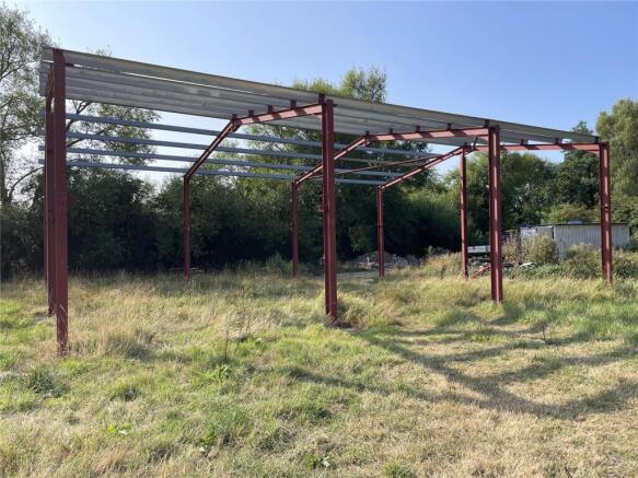
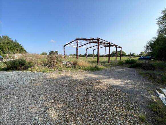
- Part constructed steel framed building
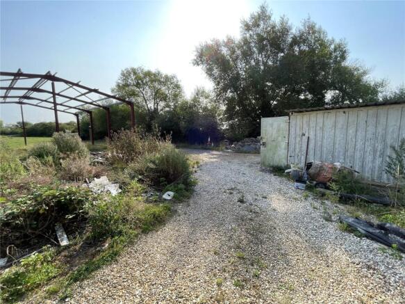
- Shipping container
- Livestock shelters
- Water
- Close to Hewish/Sandford
Description
Two livestock shelters within small, enclosed paddocks lie at the north-east of the parcel.
The land is of a flat topography and bounded on two sides by a rhyne, one side a timber fence and a mature hedgerow on the fourth side.
DESCRIPTION
An opportunity to purchase 2.12 acres (0.85 hectares) of pastureland with an area of hardstanding. There is a partially constructed steel framed building on site and a shipping container for storage. Two livestock shelters within small, enclosed paddocks lie at the north-east of the parcel. The land is of a flat topography and bounded on two sides by a rhyne, one side a timber fence and a mature hedgerow on the fourth side. Access is along Drove Way then onto Nye Drove, a public bridleway, via a right of way over the driveway to Rookery Farm East, then up a small track to the left hand side. We have assumed that vehicular access is allowed Nye Drove. There is a standard five bar metal gate to the land.
LOCATION
The property is in close proximity to the village of Sandford and the main A368 providing access between Banwell and Langford. What3Words: tenure.pancake.gums
SERVICES
Mains water connected. Rhyne watering is available.
DESIGNATIONS
Under the North Somerset Local Plan the land is subject to the following designations: - Greater Horseshoe Bats Habitat - Aerodrome Safeguard Zone - Flood Zone 3: High probability of flooding from rivers and the sea
VIEWINGS
At any reasonable daylight hour with a set of sales particulars and with the usual courtesy shown to the occupier. Please contact the Agent David James (01934-864300) prior to your visit to advise that you are viewing the site.
GUIDE PRICE
£150,000
Brochures
Nye Drove, Hewish, North Somerset, BS24

NEAREST STATIONS
Distances are straight line measurements from the centre of the postcode- Worle Station2.8 miles
- Yatton Station2.9 miles
- Weston Milton Station4.1 miles
Notes
Disclaimer - Property reference WRU240036. The information displayed about this property comprises a property advertisement. Rightmove.co.uk makes no warranty as to the accuracy or completeness of the advertisement or any linked or associated information, and Rightmove has no control over the content. This property advertisement does not constitute property particulars. The information is provided and maintained by David James, Wrington. Please contact the selling agent or developer directly to obtain any information which may be available under the terms of The Energy Performance of Buildings (Certificates and Inspections) (England and Wales) Regulations 2007 or the Home Report if in relation to a residential property in Scotland.
Map data ©OpenStreetMap contributors.