Thatcham, RG19 - BEST & FINAL OFFERS INVITED BY NO LATER THAN 17:00, FRIDAY 12TH SEPTEMBER
- PROPERTY TYPE
Land
- SIZE
484 sq ft
45 sq m
Key features
- SEE AND PRINT PDF SALES PARTICULARS AVAILABLE BELOW
- SEE DRONE VIDEO FOOTAGE ON THE VIRTUAL TOUR TAB
- DEVELOPMENT OPPORTUNITY
- PERMITTED DEVELOPMENT - CLASS Q RESIDENTIAL CONSENT (APPROX. 45 SQ M/484 SQ FT)
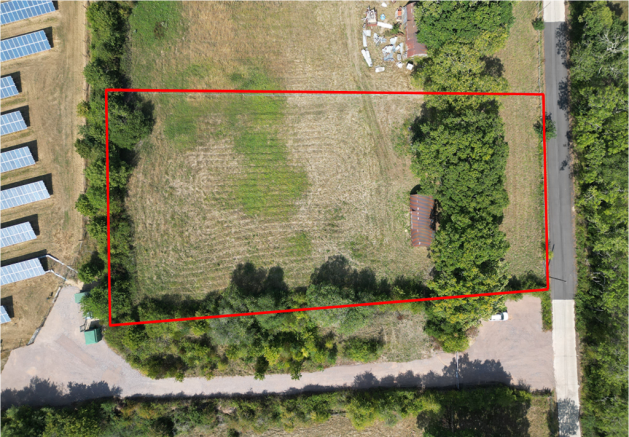
- SET WITHIN A CURTILAGE OF APPROX. 1.06 ACRES (0.43 HA)
- CLOSE TO THE HISTORIC MARKET TOWN OF THATCHAM
- SEPARATE ACCESS FROM PRIVATE ROAD LEADING TO CROOKHAM COMMON ROAD
- WITHIN WALKING DISTANCE OF THE SCENIC KENNET AND AVON CANAL
- CONVENIENT LOCATION FOR ACCESS TO LOCAL AMENITIES
- ATTRACTIVE RURAL SETTING
Description
What3words for Access: balancing.clocking.loops
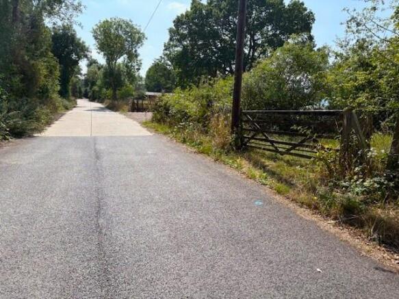
The property is located off a private road, which passes from Crookham Common Road to Limberlost Farm. It is approximately 3.5 miles by road from Thatcham and approximately 6 miles from Newbury, where local amenities including shops and pubs are available.
Highly regarded state secondaries such as Kennet School, Theale Green, The Downs and Trinity are within easy reach. For those seeking independent education, prestigious names including Downe House, St Gabriel's, Thorngrove and Horris Hill are all close by, providing outstanding opportunities from nursery through to sixth form.
As regards transport links, the A4 is around 3 miles away, with the A34 around 6 miles and the M4 (J13) approximately 10 miles. Thatcham railway station (2 miles) and Newbury station (6 miles) offer regular services to Reading and London Paddington.
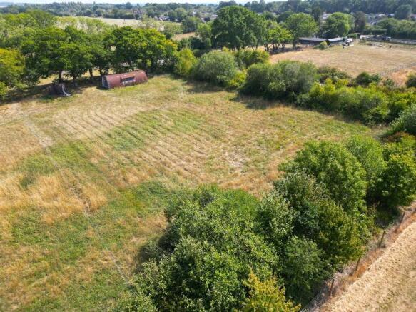
DESCRIPTION: The property includes a Nissen hut thought to have been erected in the late 1960's. It is likely that prior to this, the hut was in miliary use and its construction suggests that following this, it was in use for housing birds. There were originally seven Nissen huts within the property and the neighbouring field, parcels of which three currently remain in varying conditions. Two of these are sited on the property being marketed, although the second has largely collapsed and can no longer be described as a structure. The other benefits from a Class Q planning consent to convert to a residential dwelling, are further described below.
The Nissen hut is rectangular measuring approximately 4.88m by 10.97m / 16.01ft by 35.99ft and comprises of a single-storey, steel frame, under a curved roof. Internally the building is divided into six equal bays each approx. 3.66m / 12.00ft wide. The roof comprises of corrugated galvanised steel sheeting in a semi-circular shape. The gable walls are covered in metal corrugated cladding on a timber frame. There is a dormer window on the west-facing elevation. The floor is concrete.
The property is bounded on the east side by a row of mature trees. Beyond this is a pasture area included with the property which provides a buffer for the Nissen hut from the road. The land (currently pastureland) included with the building, extends to approx. 1.06 acre (0.43 ha), as outlined red on the Site Plan with most of this being to the west of the Nissen hut. The building is in a very attractive rural setting.
ACCESS: By Conveyance dated 19th November 1954 and Deed of Grant dated 3rd January 1956, a right of way at all times and for all purposes with and without vehicles was granted benefitting the property and also the neighbouring Limberlost Farm along the roadway, which passes from Crookham Common Road. A gateway off this roadway provides access directly to the property as shown by the arrow on the Site Plan. Copies of Conveyance and Deed of Grant are available on the Selling Agent's website.
CLASS Q - PLANNING CONSENT: By planning consent 24/02744/PACOU dated 3rd March 2025, permission has been granted for the conversion of the Nissen hut on the property to a residential dwelling with a gross internal floorspace of approx. 45 sq. m. / 484 sq. ft. The planning consent states that the development permitted must be completed by the expiration of three years from the date of permission. Conditions on the Decision Notice include requirements to install an electric vehicle charging point, cycle parking/storage facilities as well as requirements to comply with Biodiversity Net Gain requirements. The approved Floorplan/elevations, Structural Assessment and Decision Notice are available on the Selling Agent's website. Full details of the application can be obtained via the following link to the West Berkshire local planning website- 24/02744/PACOU
KENNET AND AVON CANAL: The picturesque Kennet & Avon Canal is approximately 1.5 miles to the north of the property and can be accessed using the public footpath that follows the route of the roadway used to access the property. The Canal is a tranquil waterway that winds through charming countryside and historic towns, offering miles of scenic towpath walks, cycling routes and opportunities for boating.
LAND REGISTRY: The property comprises the entirety of Land Registry Title BK532200. A copy of Land Registry Title Plan and Register is available on the Selling Agent's website. A legal process is currently ongoing to correct the southern boundary of the property on the Land Registry Title Plan, as it currently differs from the position of the boundary features and the land historically occupied.
PLANNING: The property is within the West Berkshire Council planning area and the Adopted Local Plan shows the land to be 'countryside' and outside of settlement boundaries. It is located within a mineral safeguarding area. There are four recent planning applications on record, all relating to the conversion of the Nissen hut (See Planning History on Selling Agents website). The most recent and relevant is the Class Q Permitted Development Rights for the conversion of the Nissen hut to a residential dwelling (24/02744/PACOU) granted consent on 3rd March 2025.
DESIGNATIONS: The property is within the Thames Basin Heaths National Character Area. The western part of the property is historic landfill. No other significant environmental designations have been identified.
PUBLIC RIGHTS OF WAY: The Definitive Map of Public Rights of Way suggests that the eastern part of the property is affected by a public footpath as shown by the orange dashed line on the Site Plan (Thatcham 26/1). In reality, as an inspection of the property will show there is no means of access for walkers to cross the property along this route. The Seller confirms that, to her memory, members of the public have always walked along the roadway at the eastern boundary of the property and have never used the route shown on the Definitive Map. In light of this, it may be possible to get a diversion of the footpath so that it no longer affects the property.
OTHER RIGHTS AND RESTRICTIONS: There are a number of rights and restrictions referred to on the Title Register (available on Selling Agent's website). The Seller is seeking legal advice in relation to covenants imposed on the land by a Conveyance dated 16th June 1941 (available on the Selling Agent's website) and if these remain valid and enforceable. The Selling Agent will be advised later in the marketing campaign. By Transfer dated 19th January 2024 (available on Selling Agent's website), the property benefits from the right to connect to and use utilities within neighbouring land to the north, with reciprocal rights available to the owners of the neighbouring land.
COMMUNITY INFRASTRUCTURE LEVY (CIL): By letter dated for 16th April 2025, West Berkshire Council have confirmed that development of the building in accordance with planning consent 24/02744/PACOU would be liable for a CIL payment of £5,205.19. This will be payable by the developer prior to the implementation of the planning consent, unless a self-build exemption is claimed. Copy of Letter available on the Selling Agent's website.
HABITAT REGULATION ASSESSMENT: The property is located within the Impact Risk Zone for the Greenham and Crookham Commons SSSI, which is around 300m to the south. It is likely therefore that in accordance with the General Permitted Development Order 2015 and the Conservation of Habitats and Species Regulations 2017, there will be a requirement to consult Natural England and undertake a Habitat Regulation Assessment before implementing the Class Q consent.
NORTHERN BOUNDARY - FENCING: The position of the northern boundary of the property is currently identified by a temporary fence comprising blue string on wooden posts. The purchaser would be responsible for erecting and maintaining a permanent fence along this boundary following completion. The Sellers have suggested a post and rail with sheep wire.
SERVICES: There are currently no services (water or electric) connected to the property. As mentioned above, the property does benefit from the right to connect to services in neighbouring land although these would likely be sub-metered from private supplies, rather than being direct connections to the local supply networks. To simplify matters, parties are advised to make their own investigations regarding the process and cost for new connections directly to the local supply networks if they wish to bring services onto the property.
LOCAL AUTHORITY: West Berkshire Council, Council Offices, Market Street, Newbury, RG14 5LD.
Brochures
Sales ParticularsThatcham, RG19 - BEST & FINAL OFFERS INVITED BY NO LATER THAN 17:00, FRIDAY 12TH SEPTEMBER

NEAREST STATIONS
Distances are straight line measurements from the centre of the postcode- Thatcham Station1.1 miles
- Midgham Station2.6 miles
- Newbury Racecourse Station3.5 miles
About Giles Wheeler-Bennett, Southampton
West Court, Lower Basingwell Street, Bishop's Waltham, SO32 1AJ
Notes
Disclaimer - Property reference Limberlost. The information displayed about this property comprises a property advertisement. Rightmove.co.uk makes no warranty as to the accuracy or completeness of the advertisement or any linked or associated information, and Rightmove has no control over the content. This property advertisement does not constitute property particulars. The information is provided and maintained by Giles Wheeler-Bennett, Southampton. Please contact the selling agent or developer directly to obtain any information which may be available under the terms of The Energy Performance of Buildings (Certificates and Inspections) (England and Wales) Regulations 2007 or the Home Report if in relation to a residential property in Scotland.
Map data ©OpenStreetMap contributors.