
Land at Whatcote, Idlicote Road, Shipston-on-Stour, CV36 5DY
- PROPERTY TYPE
Land
- SIZE
262,667 sq ft
24,403 sq m
Key features
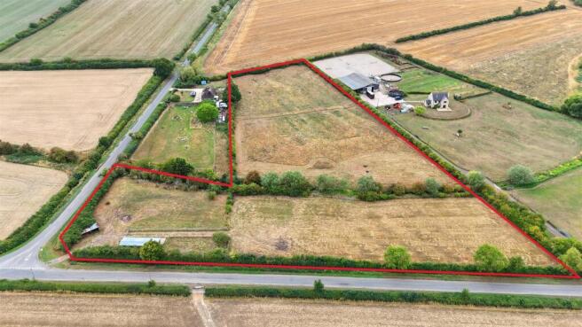
- 6.03 acres (2.44 ha) of Grade 3 pasture
- Situated less than half a mile from Whatcote and less than a mile from Fulready
- Freehold with vacant possession
- Direct road access
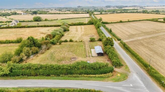
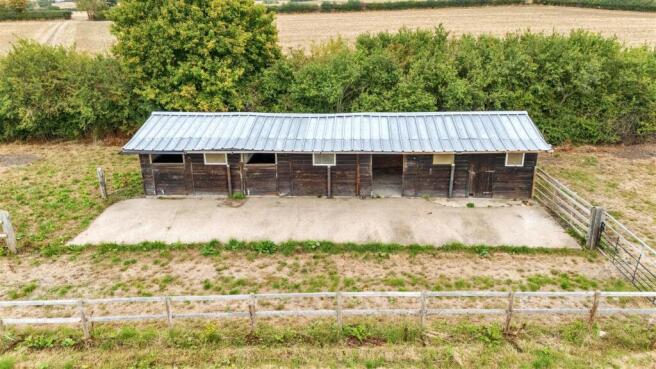
- 90sq m of timber stables with metal roof sheeting and concrete flooring
- Stone track and hard standing
- In family ownership for 40 years
Description
The land includes 5.21 acres (2.11 ha) of permanent pasture, a pole barn, and 0.82 acres (0.33 ha) of stable area. The stables extend to approximately 90sq m and are constructed using timber with concrete flooring and metal roof sheeting. There is also the benefit of 180sq m of stoned track allowing for room to turn a horse lorry, trailer, or additional parking. The land also benefits from mains waters and a brook that runs across the width of the land.
The land is classified as Grade 3 land under the Provisional Agricultural Land Classification (ALC).
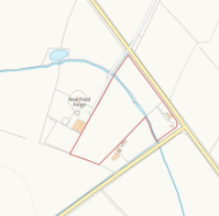
Situation - The land is located between Whatcote (within half a mile south east) and Fulready (under a mile north). It is 4 miles north east of Shipston-on-Stour and 9 miles south east of Wellesbourne.
Access - The land is accessed to the east of the junction from Idlicote Road to Whatcote Road which runs from Oxhill to Fulready. There is a stone track and hard standing across part of the holding. The gate is a galvanised steel agricultural gate and there is room to fit one car in front of it, and there is additional parking within the holding.
Services - Mains water (with a meter) is available to the holding. Buyers must rely on their own due diligence in establishing connections.
Sporting, Timber, And Mineral Rights - The sporting, timber and mineral rights in so far as they exist are included in the freehold sale.
Rights Of Way, Wayleaves, Easements & Boundaries - There are no known rights of way over the land.
Designations - The land is located within a Nitrate Vulnerable Zone for surface water, and part of the land is within Flood Zone 2 & 3. A brook runs across the land, as can be identified on the accompanying Plan.
Tenure And Possession - The land is sold freehold with vacant possession available upon completion. The Land Registry title number is: WK332251.
Planning - The land will be subject to a new restrictive covenant, limiting the use to agricultural and non-commercial equestrian.
Rural Payments Agency - The land is not registered under the Rural Payments Agency insofar as the agent is aware. Buyer's must rely on their own due diligence.
Environmental Stewardship - There are no known schemes on the land.
Plans, Areas And Schedules - These are based on the Land App computerised digitised mapping data. They have been checked and computed by the selling agents, but the Purchaser shall be deemed to have satisfied themselves as to the description and boundaries of the property. Any error or mis-statement shall not annul the sale.
Viewings - Interested parties may view the land at any time during daylight hours carrying a set of Sales Particulars, having first registered their interest and a time and date of inspection with Sheldon Bosley Knight Rural Team at Shipston on or by email to the Agent, Ella Bentall, at eleanor.
Health And Safety - We would like to bring to your attention that this is agricultural land and request that you take considerable care for your own personal wellbeing during viewings.
Local Authorities - Warwickshire County Council
Stratford-on-Avon District Council
Method Of Sale - Land is offered for sale by Private Treaty and the Vendor reserves the right for an Informal Tender. Freehold with Vacant Possession available on completion.
What3words - ///sprouted.month.cheesy
Money Laundering, Terrorist Financing And Transfer - We are governed by the Anti-Money Laundering Legislation and are obliged to report any knowledge or suspicion of money laundering to the National Criminal Intelligence Service. Therefore, if you purchase this property you will be required to produce photographic identification and a utility bill for your current address in accordance with this Act. Without identification a sale cannot proceed.
Vat - Any guide price stated or mentioned is exclusive of VAT. If the sale of the property, or any part thereof, or any right associated with it, is subject to VAT, this tax will be payable in addition.
Soil Type - The soil is classed as slowly permeable seasonally wet slightly acid but base-rich loamy and clayey soils, it is of moderate fertility with impeded drainage (Soilscape 18).
Brochures
Land at Whatcote, Idlicote Road, Shipston-on-StourLand at Whatcote, Idlicote Road, Shipston-on-Stour, CV36 5DY

NEAREST STATIONS
Distances are straight line measurements from the centre of the postcode- Stratford-upon-Avon Station8.9 miles

About Sheldon Bosley Knight, Shipston-On-Stour
The Corner House Market Place, Barcheston, Shipston-On-Stour, CV36 4AGNotes
Disclaimer - Property reference 34124039. The information displayed about this property comprises a property advertisement. Rightmove.co.uk makes no warranty as to the accuracy or completeness of the advertisement or any linked or associated information, and Rightmove has no control over the content. This property advertisement does not constitute property particulars. The information is provided and maintained by Sheldon Bosley Knight, Shipston-On-Stour. Please contact the selling agent or developer directly to obtain any information which may be available under the terms of The Energy Performance of Buildings (Certificates and Inspections) (England and Wales) Regulations 2007 or the Home Report if in relation to a residential property in Scotland.
Map data ©OpenStreetMap contributors.