
Building Plot w/ Full Planning Permission, Cross Houses
- PROPERTY TYPE
Plot
- BEDROOMS
4
- BATHROOMS
3
- SIZE
2,690 sq ft
250 sq m
Description
The village itself benefits from a well-stocked convenience store and post office (1 minute walk) as well as a village pub. A 2 minute drive down Atcham Lane will take you to the very popular Mytton & Mermaid pub and Attingham Park, a National Trust country house with extensive parkland offering beautiful riverside and woodland walks. The Riverside, another popular pub is only a 3 minute drive and can be easily combined with beautiful walks around Cound and surrounding areas. The location provides convenient access to the M54 whilst Co-Op and Meole Brace retail park are just 2.3 miles and 3 miles away respectively.
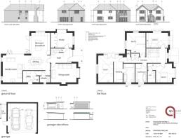
The full planning permission (25/02000/FUL) allows for a generous 250sqm (2690sqft), four bedroom, three bathroom detached luxury home with multiple reception rooms and an impressive open plan living space to enjoy with family and friends. Features include a double height entrance hall, two wood burning stoves, feature windows, master suite complete with Juliet balcony overlooking open countryside, walk-in wardrobe and a spacious en-suite bathroom.
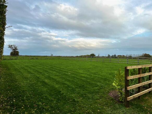
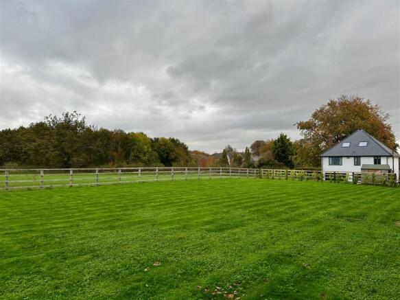
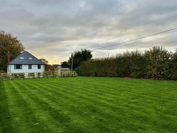
The plot will have a private entrance along the side of the existing property which leads to a spacious driveway and detached double garage. Gardens overlooking adjoining fields wrap the north and west elevations offering plenty of space for family activities whilst the sheltered patio area is the perfect spot to enjoy the evening sunset and entertain guests via bi-folding doors for the ultimate inside/outside space feel.
Notes To Purchaser - The planning permission limits the plot to a self-build single dwelling. In accordance with the Self-build and Custom Housebuilding Act 2015 (as amended).
As a self-build dwelling under this Act, the self-build purchaser will not be required to meet Biodiversity Net Gain (BNG) requirements and will be eligible for an exemption from the Community Infrastructure Levy (CIL).
The purchaser may be able to amend the house design should they wish but a new planning application may be required at their expense and any redesigns would be subject to the seller's approval given they own and live in the house which currently forms part of the plot.
Non self-build developers should bear in mind that a new planning application will be required to re-word the approval, this will require a Full Biodiversity Net Gain (BNG) Assessment, and implementation, they will also be responsible to pay the Community Infrastructure Levy (CIL) contributions.
Purchasers will be required to complete the build within 3 years of purchase.
The owners of the existing dwelling intend to finish the hardstanding areas to the front of their property on completion of sale. This will include planting a Laurel hedge to their left and rear boundaries, together with further post and rail fencing to match the existing.
Purchasers should be aware that 3D models used are for illustrative purposes only.
Please note that the plot is owned by an employee at Cooper Green Pooks.
Brochures
Property Details.pdfBuilding Plot w/ Full Planning Permission, Cross Houses

NEAREST STATIONS
Distances are straight line measurements from the centre of the postcode- Shrewsbury Station4.3 miles
- Yorton Station10.3 miles

About Cooper Green Pooks, Shrewsbury
3 Barker Street Shrewsbury Shropshire, SY1 1QF


Notes
Disclaimer - Property reference 34153102. The information displayed about this property comprises a property advertisement. Rightmove.co.uk makes no warranty as to the accuracy or completeness of the advertisement or any linked or associated information, and Rightmove has no control over the content. This property advertisement does not constitute property particulars. The information is provided and maintained by Cooper Green Pooks, Shrewsbury. Please contact the selling agent or developer directly to obtain any information which may be available under the terms of The Energy Performance of Buildings (Certificates and Inspections) (England and Wales) Regulations 2007 or the Home Report if in relation to a residential property in Scotland.
Map data ©OpenStreetMap contributors.