
Land for sale
Market Rasen Road, Holton-le-Moor, Market Rasen, Lincolnshire, LN7

- PROPERTY TYPE
Land
- SIZE
35,027,467 sq ft
3,254,161 sq m
Key features
- Large grain store located in the centre of the land
- General purpose farm building scope for a number of potential alternative uses
- The land benefits from good roadside access
- In all about 805.19 acres
- Available as a whole or in 4 lots
Description
Description
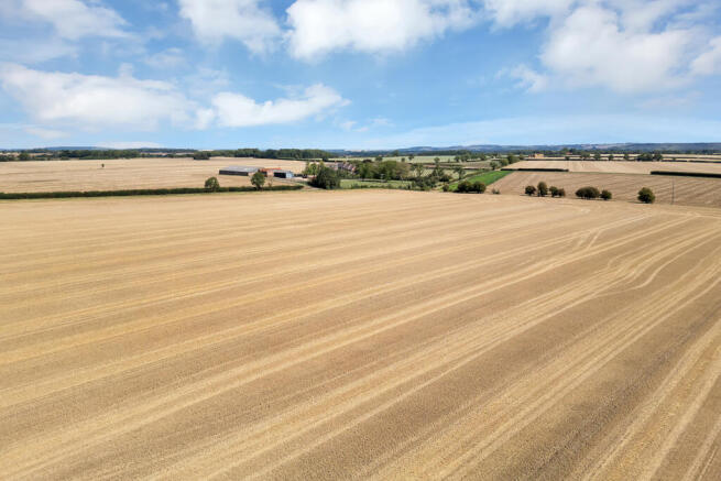
The land at Holton le Moor is spread across three farm holdings extending to approximately 805.19 acres of Grade 3 land, forming a productive arable holdings that is largely ring-fenced. The farm sits to the southwest of Caistor and north of Market Rasen, directly west of the village of Holton le Moor.
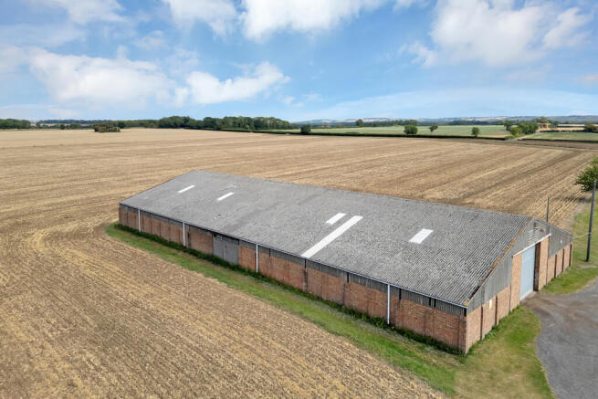
The land lies in a ring fence with a public highway dividing the land and enabling good access, there are no residential properties included in the sale. The farmyard features a substantial grain store with a concrete floor and concrete apron to the front.
The land consists of large, workable fields which have benefitted from extensive ditch management and drainage schemes to support efficient farming operations.
Lot 1 - 352.27 acres of land.
It lies to the east of Holton le Moor with access being taken from Gipsy Lane. There are two central farm tracks running from the public highway which allow for access throughout the land.
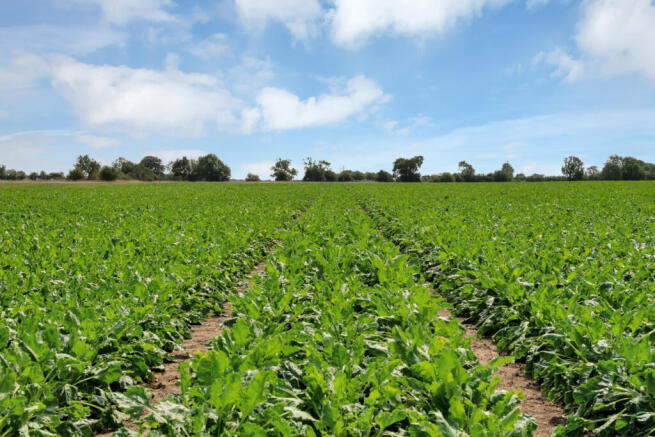
The land is classified as grade 3 on the provisional agricultural land classification map. The soil forms part of the Becceles 1 soil series, which are described as fine loamy over fine clayey soils capable of growing cereals and other combinable crops. The land running to the east closer to Holton le Moor has a greater content of sand, increasing the flexibility of the soils, with sugar beet and other root crops being grown across these fields.
The land is capable of consistently producing high yielding combinable crops alongside root crops on the eastern parcels of land.
Lot 2 - 152.86 acres of land.
The land is all down to arable, access is taken from Gipsy Lane to the land, with wide access points suitable for modern farm machinery. The land gently slopes down to the southern boundary, here there is a dyke.
The land is classified as grade 3 on the provisional agricultural land classification map. The soil forms part of the Becceles 1 soil series which are described as fine loamy over fine clayey soils capable of growing cereals and other combinable crops.
Lot 3 - 217.18 acres of land.
The land runs to the west from Gipsy Lane. The land is accessed via a shared access with the neighbouring residential property. This access leads to the grain store which is constructed from a steel frame with cement fibre roofing and red brick walling. The grain store has capacity for 2,000 tonnes of crop and benefits from on floor drying, access is via a roller shutter door.
The land is classified as grade 3 on the provisional agricultural land classification map. The soil forms part of the Becceles 1 soil series which are described as fine loamy over fine clayey soils capable of growing cereals and other combinable crops.
There is a central track running through the land allowing for good access throughout this parcel. The land gently undulates with the fields all being of a regular size suitable for modern machinery and farming practices.
Lot 4 - 82.88 acres of land.
The land is all down to arable production. There is a general purpose farm building that has been used for a variety of purposes including a grain store and pig housing. The building is constructed from a steel frame, cement fibre roofing and corrugated steel cladding.
Subject to relevant planning permission being obtained the building could be converted to a number of alternative uses. The building benefits from mains water and electricity connection.
Access for the land is taken from Gipsy Lane, a track runs from the farm building through the agricultural land. The land is classified as grade 3 on the provisional agricultural land classification map. The soil forms part of the Becceles 1 soil series which are described as fine loamy over fine clayey soils
capable of growing cereals and other combinable crops.
The land is divided by hedgerows which are regularly maintained and in good heart.
Location
The land lies on the edge of the Lincolnshire Wolds and borders the village of Holton le Moor, to the east of the farm. It is approximately 6 miles north of Market Rasen, which provides amenities including supermarkets, a post office, and a selection of pubs and restaurants. For more extensive facilities, the cathedral city of Lincoln is 25 miles to the south west, offering a wide range of shopping, leisure and cultural attractions. Nearby schools include the well regarded Caistor Grammar School, with primary options in both Caistor and Market Rasen.
Road: The A46 is approximately 2 miles away, providing excellent transport links north and south across Lincolnshire. The M180 lies 11 miles to the north and provides access to the wider UK motorway network.
Rail: Market Rasen train station, around 6 miles away, offers direct services to Lincoln where there are trains running to London Kings Cross with travel time of approximately 1 hour and 55 minutes.
Air: Humberside Airport is about 11 miles away, offering a range of domestic and international flights.
Acreage: 804.12 Acres
Additional Info
Local Authority: West Lindsey District Council
Photographs and Particulars: August 2025
Brochures
Web DetailsMarket Rasen Road, Holton-le-Moor, Market Rasen, Lincolnshire, LN7

NEAREST STATIONS
Distances are straight line measurements from the centre of the postcode- Market Rasen Station5.9 miles
Notes
Disclaimer - Property reference LIR250127. The information displayed about this property comprises a property advertisement. Rightmove.co.uk makes no warranty as to the accuracy or completeness of the advertisement or any linked or associated information, and Rightmove has no control over the content. This property advertisement does not constitute property particulars. The information is provided and maintained by Savills Rural Sales, Lincoln. Please contact the selling agent or developer directly to obtain any information which may be available under the terms of The Energy Performance of Buildings (Certificates and Inspections) (England and Wales) Regulations 2007 or the Home Report if in relation to a residential property in Scotland.
Map data ©OpenStreetMap contributors.