Car Park, Lowfield Street / Walnut Tree Avenue, Dartford, Kent, DA1 1LJ
- SIZE AVAILABLE
8,712 sq ft
809 sq m
- SECTOR
Light industrial facility for sale
Key features
- Car Park For Sale or To Let
- Considered Potentially Suitable for EV Charging Station Use (or Similar)
- 25-30 Car Parking Spaces
- 0.22 Acres
- Located 1.1 Miles from J2 of the M25
- Located 0.8 Miles from Dartford Town Centre
- Corner Plot Location
Description
OFFERS TO BE RECEIVED BY 4PM ON FRIDAY 10TH OCTOBER 2025
CAR PARK FOR SALE OR TO LET ---- UNCONDITIONAL OFFERS INVITED ---- CONSIDERED POTENTIALLY SUITABLE FOR EV CHARGING STATION USE (OR SIMILAR)
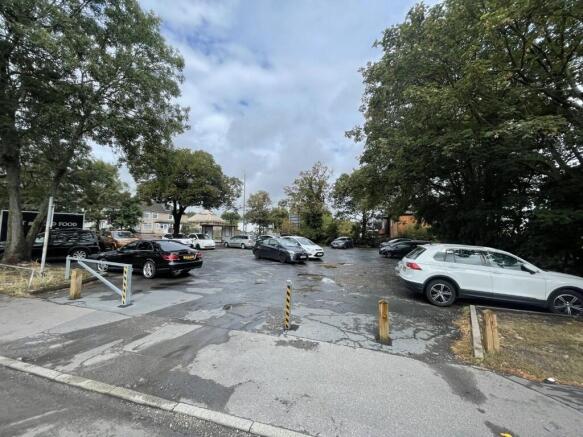
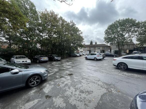
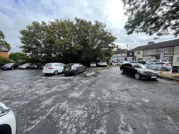
The site is a car park on the corner of Lowfield Street and Walnut Tree Avenue id Dartford, previous operated by Dartford Borough Council for the benefit of the local amenities in the area.
We are instructed to sell the site on behalf of Kent County Council which must remain as a Car Park but could be suitable for EV Charging Station (or similar).
Car Park For Sale or To Let
Considered Potentially Suitable for EV Charging Station Use (or Similar)
25-30 Car Parking Spaces
0.22 Acres
Located 1.1 Miles from J2 of the M25
Located 0.8 Miles from Dartford Town Centre
Corner Plot Location
Location
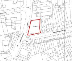
The car park is situated on the corner of Lowfield Street and Walnut Tree Avenue, just off Princes Road in Dartford. It is well situated for various local amenities including the Co-op Convenience Store but is primarily in a residential area 0.8 miles south of Dartford Town Centre.
The site is 1.1 miles from J2 of the M25 providing good opportunity for an EV hub.
What3Words Location:-
Accommodation
The site is a primarily rhombus shaped plot fronting Lowfield Street but accessed off Walnut Tree Avenue. The site has a low level barriers on the two road elevations and is fenced on the north and eastern boundaries. The car park is gated and can be secured.
There are several established trees on the boundaries of the site. The surface does have several pot-holes which require attention.
The site totals approximately 900 sq m = 9,688 sq ft = 0.22 Acres
EPC
Not Applicable
Terms
Unconditional Offers Invited for the car park site on a Freehold or a Leasehold Basis
The site must remain as a car park and there will be a restriction on Title to this event.
If Leased, the premises are immediately available by way of a new full repairing and insuring lease for a term to be agreed by negotiation and subject to upward only rent reviews to market rent
Proposals should include proposed use of the site including layout and operation.
Rent/Price
Unconditional Offers Invited for the car park site on a Freehold or a Leasehold Basis
Rateable Value / Council Tax
We understand that there is no current rating assessment on the car park
VAT
We understand from our client that the property is not elected for Value Added Tax (VAT). Prospective occupiers should satisfy themselves independently as to any VAT payable in respect of any transaction.
Viewing
The car park is open to the public currently and available for viewing at all times.
Brochures
Car Park, Lowfield Street / Walnut Tree Avenue, Dartford, Kent, DA1 1LJ

NEAREST STATIONS
Distances are straight line measurements from the centre of the postcode- Dartford Station0.9 miles
- Crayford Station1.9 miles
- Stone Crossing Station2.4 miles
About Sibley Pares Chartered Surveyors, Maidstone
Equitable House, 1 Ashford Road, Maidstone, ME14 5BJNotes
Disclaimer - Property reference 203050FH. The information displayed about this property comprises a property advertisement. Rightmove.co.uk makes no warranty as to the accuracy or completeness of the advertisement or any linked or associated information, and Rightmove has no control over the content. This property advertisement does not constitute property particulars. The information is provided and maintained by Sibley Pares Chartered Surveyors, Maidstone. Please contact the selling agent or developer directly to obtain any information which may be available under the terms of The Energy Performance of Buildings (Certificates and Inspections) (England and Wales) Regulations 2007 or the Home Report if in relation to a residential property in Scotland.
Map data ©OpenStreetMap contributors.