
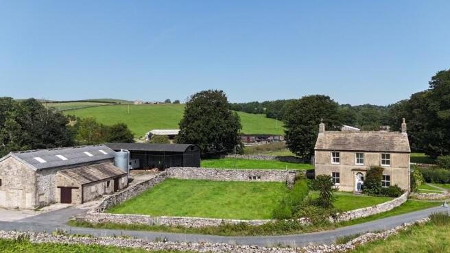


Winterburn Hall Farm, Winterburn, Gargrave, Skipton, North Yorkshire BD23 3QR

- PROPERTY TYPE
Farm
- BEDROOMS
5
- SIZE
9,888,120 sq ft
918,637 sq m


Key features
- For sale as a whole or in six lots
- Lot 1 - Winterburn Farmhouse & Steading - Guide Price - £770,000
- Lot 2 - Traditional Buildings & approx. 1 Acre of Land - Guide Price - £150,000
- Lot 3 - Land at Banks Hill extending to approximately 77.29 acres (31.28 hectares) - Guide Price - £600,000
- Lot 4 - Land at Hills Lane extending to approximately 69.53 acres (28.14 hectares) - Guide Price - £420,000
- Lot 5 - Land at Tarn Flat extending to approximately 62.08 acres (25.12 hectares) - Guide Price - £440,000
- Lot 6 - Land at Abbey Hill extending to approximately 15.16 acres (6.13 hectares) - Guide Price - £120,000
- For sale by private treaty
Description
LOCATION
Winterburn Hall Farm is set in a scenic location within the rolling beauty of the Yorkshire Dales National Park. The farm is positioned at the heart of the idyllic village of Winterburn which lies a short distance south-west of Grassington and approximately 7 miles from the thriving market town of Skipton. Skipton offers a wide range of amenities including independent shops, supermarkets, well regarded education establishments and excellent transport links to Leeds, York and beyond. There are popular livestock markets at Skipton, Gisburn, Bentham and Clitheroe, which are all easily accessible from Winterburn.
Winterburn Hall Farm is accessed directly off Winterburn Lane with the majority of the land having good roadside access.
What3Words: ///rivals.results.canals
Designations
We are not aware of any designations affecting the holding other than being located within the Yorkshire Dales National Park.
Council Tax
The Council Tax band for Winterburn Hall Farmhouse is Band D.
Energy Performance Certificate
Winterburn Hall Farmhouse currently has an EPC rating of F.
Wayleaves, Easements and Rights of Way
The property is sold subject to and with the benefit of all existing Easements, Wayleaves and Rights of Way whether public or private and whether mentioned or not.
Environmental Schemes and Grants
There is an existing Countryside Stewardship Mid-Tier scheme covering some of the land. Further information can be obtained from the Selling Agent.
Sporting and Mineral Rights
The sporting and mineral rights are included in the sale, in so far as they are owned.
Tenure
The property is offered freehold with vacant possession upon completion.
Method of Sale
The property is offered for sale by private treaty as a whole or in six Lots. All prospective purchasers must register their interest with the Selling Agent.
Enquiries
To enquire further or request an offer pack please contact the Selling Agents Davis & Bowring.
Viewings
Viewings of the land are permitted during daylight hours subject to possessing a copy of the sale particulars. Viewings of Lot 1 and Lot 2 are strictly by appointment with the Selling Agents Davis & Bowring, contact number:
Brochures
ParticularsWinterburn Hall Farm, Winterburn, Gargrave, Skipton, North Yorkshire BD23 3QR

NEAREST STATIONS
Distances are straight line measurements from the centre of the postcode- Gargrave Station3.1 miles
- Skipton Station5.4 miles

About Davis & Bowring, Kirkby Lonsdale
Lane House, Kendal Road, Kirkby Lonsdale, Via Carnforth, LA6 2HH


Notes
Disclaimer - Property reference DB110. The information displayed about this property comprises a property advertisement. Rightmove.co.uk makes no warranty as to the accuracy or completeness of the advertisement or any linked or associated information, and Rightmove has no control over the content. This property advertisement does not constitute property particulars. The information is provided and maintained by Davis & Bowring, Kirkby Lonsdale. Please contact the selling agent or developer directly to obtain any information which may be available under the terms of The Energy Performance of Buildings (Certificates and Inspections) (England and Wales) Regulations 2007 or the Home Report if in relation to a residential property in Scotland.
Map data ©OpenStreetMap contributors.