Land South Of Chantry Farm, Chantry Lane, Todds Green, Stevenage, Hertfordshire, SG1 2JE
£25.51 per sq ft
Business rates & charges may apply

- SIZE AVAILABLE
58,806 sq ft
5,463 sq m
- SECTOR
Land for sale
Key features
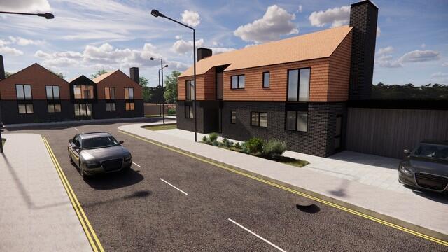
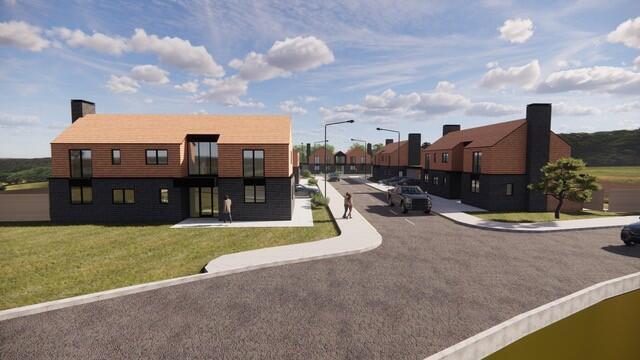
- Outline planning permission for up to 5 executive homes
- Highly desirable semi-rural location with strong commuter links
- Flexibility at Reserved Matters stage to meet buyer demand
- Site extending to approximately 1.35 acres (0.54 hectares)
- Generous proposed accommodation approx. 1,188 sq m (12,791 sq ft)
- Freehold interest available with vacant possession
- No affordable housing
Description
Outstanding development opportunity with outline planning permission for up to five executive homes, set on a 1.35-acre (0.54 ha) level and well-bounded site. Ideally located in a sought-after semi-rural setting with excellent commuter links - just 21 minutes to London King's Cross.
Location
Todds Green is a small, semi-rural settlement located near Stevenage in Hertfordshire. The area offers a balance of countryside surroundings and convenient access to key transport routes, including the A1(M) and A602. It is well placed for commuters, with nearby Stevenage railway station providing regular services to London Kings Cross (approximately 21 minutes) and Cambridge (approximately 40 minutes).
Todd's Green maintains a quiet, village-style atmosphere with access to open green spaces and essential local amenities, offering a peaceful setting close to larger towns but surrounded by larger local towns such as Hitchin and Stevenage. Hitchen is a charming historic market town, and equally Stevenage is currently undergoing a £1 billion redevelopment project, set to reshape the town centre into a vibrant, mixed-use destination offering efficient access to London.
Detailed Description
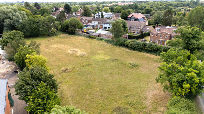
The site comprises approximately 0.54 hectares (1.35 acres) of level grassland, currently in equestrian use. Natural boundaries of mature hedgerows and trees provide both privacy and an attractive rural setting.
With direct access from Chantry Lane, the land connects smoothly to the local and regional road network. Its regular shape, manageable size, and limited physical constraints create an excellent opportunity for residential development.
Planning Background
The property lies within the jurisdiction of Stevenage Borough Council, as set out in the Stevenage Local Plan (2011-2031).
Outline planning consent was granted on 9 September 2024 (Ref: 24/00196/OP) for up to five high-quality dwellings. Importantly, there are no affordable housing or Biodiversity Net Gain requirements, ensuring a straightforward planning pathway.
The consent has been structured to provide design flexibility, enabling developers to finalise layouts, scale and style at Reserved Matters stage. This freedom means homes can be tailored to either traditional family living or more contemporary designs, depending on market.
Time Limits
Reserved Matters to be submitted within 3 years of outline permission
Development must commence within 5 years of permission, or within 2 years of Reserved Matters approval (whichever is later)
Reserved Matters Requirements
Approval will be required for:
Layout
Scale
Appearance
Access
Landscaping
Pre-commencement conditions include: Construction Management Plan (vehicles, compounds, timings, access)
Tree protection scheme
Infrastructure details (roads, drainage, parking, turning)
Prior to construction above slab level:
Climate adaptation/efficiency measures
Boundary treatments (walls, fences, gates)
Landscaping and planting scheme
Car parking with SuDS/permeable surfacing
Additional requirements:
EV charging: all parking spaces EV-ready before occupation
Waste & cycle storage to be agreed and installed before occupation
Ongoing landscaping maintenance (replacement of failed planting within 5 years)
Rights, Easements and Restrictions
The land is sold subject to and with the benefit of all public rights and private rights of way, light, drainage, overhead cable, and other easements and restrictions or obligations that exist whether the same are described in the particulars.
Accommodation
Plot Schedule (Indicative)
Plot Type Bedrooms GIA (m) GIA (sq ft)
1 Two-storey house 5 204 2,196
2 Two-storey house 4 180 1,938
3 Two-storey house 6 318 3,423
4 Two-storey house 4 180 1,938
5 Two-storey house 4 180 1,938
Each dwelling will benefit from:
Minimum 200 m private rear garden
Minimum 2 off-road parking spaces
100 m of communal landscaped space
Business Rates
The property may benefit from Small Business Rates Relief which may reduce the rates payable. Please contact the agents for more information.
Services
It is understood relevant services are available in the details of which are provided in the Development Information Pack. Prospective Purchasers will however be expected to satisfy themselves as to the availability and adequacy of the supplies by making their own enquiries to the relevant service company/authority.
VAT
It is understood VAT will not payable on the sale, however if the sale of the site or any associated rights become chargeable for VAT this shall be paid for by the purchaser
Legal Costs
The buyer will be responsible for paying their own legal costs.
Viewing
For further information or to arrange a viewing please contact:
Guy Acott-Smith
T: | guy.acott-
Simon Harvey
T: | simon.
Brochures
Land South Of Chantry Farm, Chantry Lane, Todds Green, Stevenage, Hertfordshire, SG1 2JE

NEAREST STATIONS
Distances are straight line measurements from the centre of the postcode- Stevenage Station1.8 miles
- Hitchin Station2.5 miles
- Letchworth Station3.8 miles
About Brown & Co, St. Neots
The Fairways, Wyboston Lakes, Great North Road Wyboston St. Neots MK44 3ALNotes
Disclaimer - Property reference 448566FH. The information displayed about this property comprises a property advertisement. Rightmove.co.uk makes no warranty as to the accuracy or completeness of the advertisement or any linked or associated information, and Rightmove has no control over the content. This property advertisement does not constitute property particulars. The information is provided and maintained by Brown & Co, St. Neots. Please contact the selling agent or developer directly to obtain any information which may be available under the terms of The Energy Performance of Buildings (Certificates and Inspections) (England and Wales) Regulations 2007 or the Home Report if in relation to a residential property in Scotland.
Map data ©OpenStreetMap contributors.