
Parkgatestone Farm, Kilbucho, Biggar, ML12

- PROPERTY TYPE
Detached
- BEDROOMS
5
- BATHROOMS
2
- SIZE
Ask agent
- TENUREDescribes how you own a property. There are different types of tenure - freehold, leasehold, and commonhold.Read more about tenure in our glossary page.
Freehold
Key features
- About 485 acres in total
- Traditional farmhouse (2 reception rooms and 5 bedrooms)
- Range of traditional and modern farm buildings
- 304 acres arable/silage
- 131 acres pasture
- 34 acres rough grazing
- 5 acres woodland
- EPC Rating = E
Description
Description
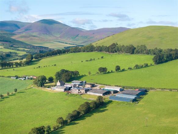
Extending to approximately 485 acres, Parkgatestone Farm is an equipped, traditional mixed farm located within the Biggar Valley. At the heart of the farm and directly accessed from the public road is a five bedroom farmhouse, and an extensive range of traditional and modern sheds. Many of the farm buildings have been upgraded over the years to suit modern farming practices.
Much of the land at Parkgatestone is utilised for temporary grass leys, forage crop and arable production. The cropping has included spring barley, swede, turnips, kale and rotational grazing. In line with the current farming system, two cuts of silage are taken per annum, although the land would be capable of producing up to four. Spring barley yields of 2.2-3.4 tonnes per acre have been reported in recent years.
The farm has been run in-hand by the vendors since 2017, with a focus on running commercial breeding sheep and beef cattle with arable rotations. The farm currently runs a flock of 1,250 breeding ewes and 250 store cattle. Lambs and cattle are finished on farm. Woodland shelter belts provide practical shelter and amenity to the holding with livestock outwintered.
The land can be summarised as follows, arable / silage 304 acres, pasture 131 acres, rough grazing 34 acres, woodland 5 acres, misc. 9 acres.
The South Lanarkshire area experiences an average rainfall of 930mm per year, and temperatures typically remain above freezing in winter, with an average of 14°C in July. (source: Drumalbin weather station -
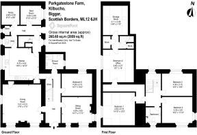
Parkgatestone Farmhouse
The traditional stone farmhouse dates back to the 1850s and has been extended over time. It sits adjacent to the farm buildings, with its own front drive and parking. The accommodation is split over two levels and provides comfortable and spacious family accommodation.
Notably, the accommodation includes a dining kitchen,
sitting room, dining room, bedroom and shower room on the ground floor, four bedrooms and a bathroom on the first floor. In addition there are a number of service rooms and stores. There is scope for the house to be renovated to provide further accommodation.
Details are shown in the accompanying floorplans and photographs.
In recent years the vendors have carried out a number of improvements, including the installation of a new bathroom on the first floor, a wood burning stove, electric central heating, double glazing and roof insulation. In addition they have redecorated rooms and maintained the roof and chimney stacks as and when required. To the front of the house is a garden mainly laid to lawn and a paddock which could easily be incorporated into the garden.
Farm Buildings
The farm buildings are made up of both modern and traditional construction which have been adapted over the years as required. They provide livestock housing, grain storage and general storage. The farm steading benefits from a private water supply from the hill, and three phase mains electricity. The steading is largely concreted and provides adequate space for gathering livestock and large machinery.
The approximate construction and dimensions of the buildings are as follows and are shown
on the building plan.
1. Farmhouse - (Gross Internal Area 265 sqm) Traditional stone walls and a pitched slate roof.
2. Traditional store - (11.82m x 5.51m) Concrete floor, stone and brick walls and slate roof.
3. Hay shed - (15.7m x 9.8m) Earth floor, steel frame and corrugated roof.
4. Modern grain store - (17.41m x 11.18m) Steel portal frame with concrete floor, concrete panel walls, box profile cladding and fibre cement roof.
5. Hay shed with lean-to - (11.05m x 10.91m) Pole barn construction, with earth floor, corrugated cladding and box profile roofing. Lean-to included.
6. Silage pit - (32.18m x 9.36m) Concrete walls with asphalt base. Capacity 500-600 tonnes.
7. General purpose store and lean-to - (24.45m x 10.99m) Steel frame, concrete floor and corrugated cladding.
8. Cattle court - (24.28m x 17.93m) Steel portal frame, concrete and earth floor, blockworks walls, box profile cladding and fibre cement roof. Central feed passage and barriers.
9. Lean-to - (17.92m x 6.23m ) Adjoining building 8, timber truss, box profile cladding and roofing.
10. Sheep shed - (29.5m x 12.40m) Timber frame, earth floor, box profile cladding and roofing.
11. Lambing shed - (35.37m x 9.22m) Steel and timber frame, earth floor, box profile cladding and roofing.
12. Cattle court and lean-to - (27.25m x 16.17m) Steel portal frame, concrete floor, corrugated cladding and asbestos roof.
13. Slatted court - (15.69 x 8.66m with 12.39 x 2.84 lean-to) Steel frame, slatted floor, blockwork walls with Yorkshire boarding and a corrugated roof.
14. Slatted court - (11.71m x 9.95m) Steel framed roof, slatted floor, blockwork walls with Yorkshire boarding and a corrugated roof.
15. General purpose store - (5.09m x 11.13m) Steel framed roof, concrete floor, stone and blockwork walls and a corrugated roof.
16. Hardstanding - Previously was an open slurry lagoon which has since been drained.
17. Cattle shed - (17.39m x 8.89m) Steel frame roof, majority concrete floor, brick and stone walls, with asbestos roof.
18. Lean-to - (9.33m x 8.16m) Steel frame, concrete floor, stone walls, corrugated cladding and roofing.
19. Converted silage pit - (26.74m x 6.12m) Steel frame, concrete floor, corrugated cladding and roofing.
20. Lean-to store - (12.49m x 4.99m) Concrete floor, stone and brick walls and corrugated roofing.
Land
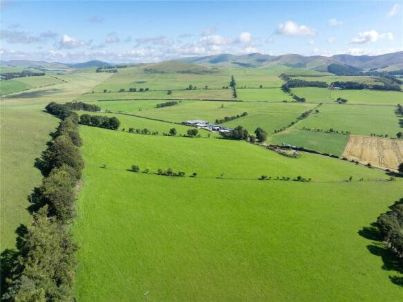
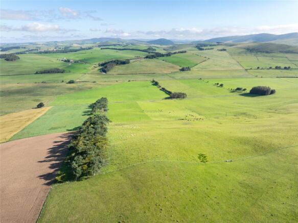
The land extends to approximately 485 acres in total and comprises 304 acres of arable/grass leys, 131 acres permanent pasture, 34 acres of rough grazings and 5 acres woodland.
Land classification for the holding includes areas of class 4.1, class 4.2 and class 5.3 by the James Hutton Institute for Soil Research, which lends itself to sustaining mixed agriculture. Soils are part of the Linhope series (brown earths), or alluvial, as defined, and present on the farm as a sandy loam that is relatively free draining. The undulations of Parkgatestone rise from about 200m (~600ft) above sea level along the northern boundary of the farm to 330m (~1000ft) above sea level close to the southern boundary.
The farm layout is practical and workable for both arable and livestock management. It benefits from being well fenced throughout with suitable access gates. Stock can be gathered
and worked easily within the farmyard. There is mains electric fencing, servicing fields to the north of the public road. This also enables provision for rotational grazing practices.
The land has benefitted from being in arable rotations, with a large proportion of the grazing being reseeded after break crops like swedes, kale, turnips or spring barley. Care has been taken to improve soil health in respect to lime applications and utilising farmyard manures to build organic matter levels.
Each compartment has access to water, which is provided from a nearby spring and many of the troughs have been upgraded.
Location
Parkgatestone Farm sits within the Parish of Broughton, Glenholm and Kilbucho, on the edge of South Lanarkshire and the Borders. The area is renowned for its productive agricultural land which is suited for mixed and livestock farming due to its moderate rainfall and well drained soils.
Local primary schooling is provided in the village of Broughton approximately *2 miles away. The village also has a tennis club, village shop and village hall. The closest town is the old market town of Biggar, *5 miles to the west. It offers a good range of shops, supermarkets, professional services and secondary schooling. Lanark *16 miles to the north west also provides a wide range of amenities and a railway station.
The farm is located in an area which provides good travel connections. The M74, the main route from England to Scotland is approximately *16 miles from the farm, the capital city of Edinburgh is situated *31 miles to the east and Glasgow is *44 miles to the west. Furthermore, the locality has a good provision of agricultural suppliers and livestock markets, including livestock markets at Lanark, Lockerbie, Stirling, Longtown and Carlisle.
*distances taken from Google Maps.
Acreage: 485 Acres
Directions
Parkgatestone Farm is located between Biggar and Broughton. It is most easily accessed from the A702 from Biggar.
From the north, on the A702, after driving down the High Street, turn left onto Boghall Road. After approximately 1.5 miles continue on the road towards Broughton. Continue for approximately 3 further miles. Parkgatestone Farm will be on your left hand side.
From the south, on the A702 before the High
Street, turn right onto Boghall Road. Follow
directions as above.
For satellite navigation purposes the postcode for
Parkgatestone is: ML12 6JH
what3words: ///darling.shipwreck.waxing
Brochures
Web Details- COUNCIL TAXA payment made to your local authority in order to pay for local services like schools, libraries, and refuse collection. The amount you pay depends on the value of the property.Read more about council Tax in our glossary page.
- Band: G
- PARKINGDetails of how and where vehicles can be parked, and any associated costs.Read more about parking in our glossary page.
- Yes
- GARDENA property has access to an outdoor space, which could be private or shared.
- Yes
- ACCESSIBILITYHow a property has been adapted to meet the needs of vulnerable or disabled individuals.Read more about accessibility in our glossary page.
- Ask agent
Parkgatestone Farm, Kilbucho, Biggar, ML12

Add an important place to see how long it'd take to get there from our property listings.
__mins driving to your place
Get an instant, personalised result:
- Show sellers you’re serious
- Secure viewings faster with agents
- No impact on your credit score
Your mortgage
Notes
Staying secure when looking for property
Ensure you're up to date with our latest advice on how to avoid fraud or scams when looking for property online.
Visit our security centre to find out moreDisclaimer - Property reference EDR220058. The information displayed about this property comprises a property advertisement. Rightmove.co.uk makes no warranty as to the accuracy or completeness of the advertisement or any linked or associated information, and Rightmove has no control over the content. This property advertisement does not constitute property particulars. The information is provided and maintained by Savills Rural Sales, Edinburgh. Please contact the selling agent or developer directly to obtain any information which may be available under the terms of The Energy Performance of Buildings (Certificates and Inspections) (England and Wales) Regulations 2007 or the Home Report if in relation to a residential property in Scotland.
*This is the average speed from the provider with the fastest broadband package available at this postcode. The average speed displayed is based on the download speeds of at least 50% of customers at peak time (8pm to 10pm). Fibre/cable services at the postcode are subject to availability and may differ between properties within a postcode. Speeds can be affected by a range of technical and environmental factors. The speed at the property may be lower than that listed above. You can check the estimated speed and confirm availability to a property prior to purchasing on the broadband provider's website. Providers may increase charges. The information is provided and maintained by Decision Technologies Limited. **This is indicative only and based on a 2-person household with multiple devices and simultaneous usage. Broadband performance is affected by multiple factors including number of occupants and devices, simultaneous usage, router range etc. For more information speak to your broadband provider.
Map data ©OpenStreetMap contributors.