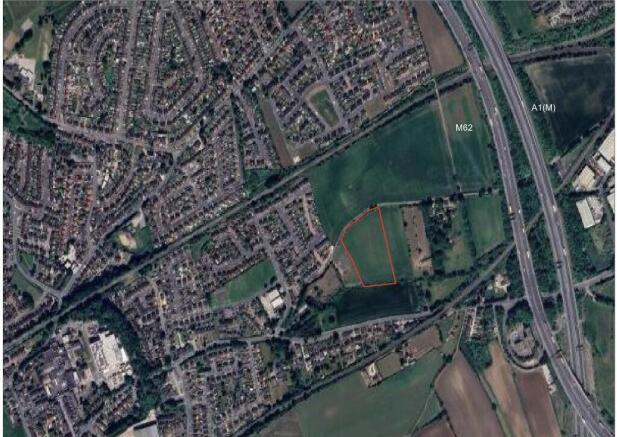
Land off Sowgate Lane, Pontefract
- PROPERTY TYPE
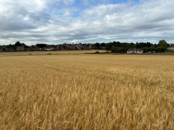
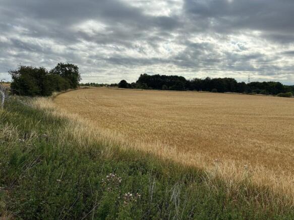
Farm Land
- SIZE
200,812 sq ft
18,656 sq m
Key features
- Reasonable shaped block of arable land
- Strategically situated to offer potential for future alternative uses, subject to obtaining the necessary planning consents
- Accessed directly off Sowgate Lane
Description
The land is situated to the north east of the town of Pontefract in West Yorkshire and is accessed directly off Sowgate Lane.
Description
The land comprises a reasonable shaped block of arable land strategically situated to offer potential for future alternative uses, subject to obtaining the necessary planning consents.
The soils are classified as being Grade 2 on Sheet 97 of the Provisional Agricultural Land Classification Maps of England and Wales as historically published by the Ministry of Agriculture Fisheries and Food.
The soils are identified by the Soil Survey of England and Wales as being from the "Aberford" Association, with their characteristics described as "shallow locally brashy, well drained, calcareous fine loamy soils over limestone, some deeper calcareous soils in colluvium," and as suitable for "cereals with some sugar beet and potatoes; limited permanent grassland."
Basic Payment Scheme
The land is registered on the Rural Payments Agency Rural Land Register and has been used to activate entitlements under the former Basic Payment Scheme.
Tenure and Possession
The land is owned freehold and it is being sold with the benefit of vacant possession upon completion.
Outgoings
None known.
Tenantright/Dilapidations
There will be no tenantright payable, likewise there will be no consideration or allowance made whatsoever for dilapidations or any other deductions of any kind.
Early Entry
Early entry on to the land will be permitted for the prospective Purchaser(s) prior to legal completion, subject to an exchange of contracts and the payment of a double deposit (20%).
Value Added Tax (VAT)
The sale price is agreed on a VAT exclusive basis and the Purchaser(s) shall indemnify the Vendors for any VAT which may subsequently be payable.
Nitrate Vulnerable Zone
The land all lies within a designated Nitrate Vulnerable Zone.
Planning
The site is currently designated as Green Belt on the Wakefield Metropolitan District Council Local Plan (2036 adopted 24th January 2024) however residential development has recently taken place on the north western side of Sowgate Lane.
The land may be deemed a suitable infill block for future development, subject to being able to obtain the necessary planning consent.
Development Clause
There is an existing development clawback provision in favour of the previous owner. This is for a 20 year period which started in 2021. This is for 12% of any uplift in value.
The vendors are also adding their own development clause/overage on the land for a period of 15 years from the date of completion. This will be implemented on the grant of planning permission, or the disposal of the land with the benefit of the permission, whichever is the sooner. The overage will also be for 12% in any uplift in value from the existing use value.
Local Authority
Interested parties should make their own enquiries in relation to the land with Wakefield Metropolitan District Council.
Wayleaves, Easements and Rights of Way
There are overhead lines crossing the field with poles in situ. There is a wayleave agreement in place with Northern Powergrid (Yorkshire) plc.
The land is sold subject to any rights of way, reservation of minerals, water, drainage, sporting rights, easements and other wayleaves and all rights of access whether mentioned in these sale particulars or not.
Viewing
The land may be viewed at any reasonable time during daylight hours in possession of a set of these sale particulars.
Method of Sale
The land is offered for sale by Private Treaty. Interested parties are invited to discuss their interest with Andrew Houlden, of the Selling Agents.
Brochures
Sales ParticularsLand off Sowgate Lane, Pontefract

NEAREST STATIONS
Distances are straight line measurements from the centre of the postcode- Knottingley Station1.1 miles
- Pontefract Monkhill Station0.8 miles
- Pontefract Baghill Station1.0 miles

Notes
Disclaimer - Property reference JH-25-135. The information displayed about this property comprises a property advertisement. Rightmove.co.uk makes no warranty as to the accuracy or completeness of the advertisement or any linked or associated information, and Rightmove has no control over the content. This property advertisement does not constitute property particulars. The information is provided and maintained by DDM Agriculture, Brigg. Please contact the selling agent or developer directly to obtain any information which may be available under the terms of The Energy Performance of Buildings (Certificates and Inspections) (England and Wales) Regulations 2007 or the Home Report if in relation to a residential property in Scotland.
Map data ©OpenStreetMap contributors.