Baylis Gap Farm, Bewerley, Harrogate
£1.20 per sq ft
Business rates & charges may apply
- SIZE AVAILABLE
1,411,344-10,381,219 sq ft
131,118-964,448 sq m
- SECTOR
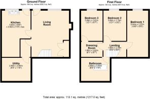
3 bedroom smallholding for sale
Key features
- Nidderdale livestock Farm
- Stone Barns with scope for redevelopment
- Extensive range of modern farm buildings
- Stone field barn
- Conservation and amenity woodland
- Productive grassland
Description
See letter and offer form available for download below
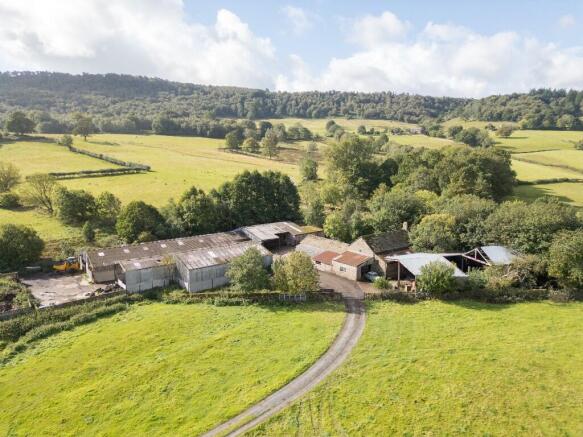
Baylis Gap Farm extends in total to 238.32Ac (96.44Ha) and comprises a stone built dales farmhouse, attached range of stone barns, extensive range of modern livestock buildings, productive grassland surrounding the steading and an extensive area of conservation woodland. The property is offered for sale as a whole or in 3 lots:
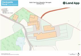
Lot 1 - Baylis Gap Farmhouse, Buildings & Grassland
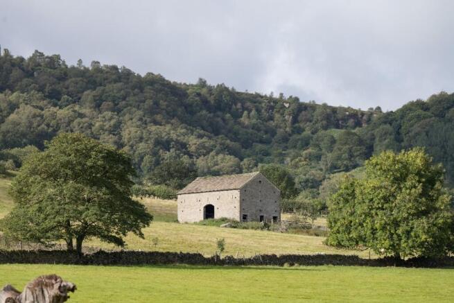
Extending in total to approximately 51.39 Ac (20.80Ha) and comprising the farmhouse, range of stone barns, yard area and modern buildings, grassland surrounding the steading and a substantial stone field barn.
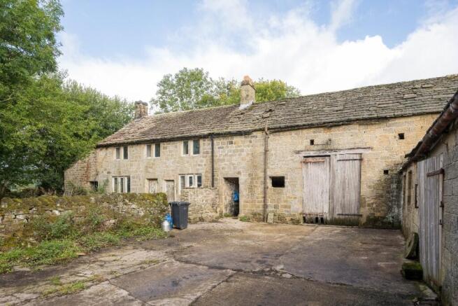
The farmhouse is a stone built double-fronted dales farmhouse is in need of complete renovation and modernisation but offering significant scope to extend into the adjoining stone barns which offer potential to form a single large dwelling of up to c.4500sqft (subject to consents). The stone barns include a large two storey barn attached to the farmhouse and single storey mistal running south, each with further lean-to buildings off the sides.
The modern farm buildings comprise a range of steel portal frame and timber frame livestock and storage buildings having housed dairy cattle but offering scope for a range of alternative uses. The buildings include the following:
Building 1 - Two storey stone barn
Building 2 - Single storey stone mistal
Building 3 - Stone built lean-to workshop
Building 4 - Timber frame straw shed (part collapsed)
Building 5 - Steel frame machinery shed
Building 6 - Steel frame cubicle shed
Building 7 - Former parlour and dairy
Building 8 - Timber frame cattle shed
The grassland surrounding the steading has been farmed in a traditional manner and comprises parcels of traditional pasture and meadow land divided by a mix of walls and wire fences. The land is accessible via a good range of tracks running from the steading.
The field barn lying to the southeast of the main farmstead is of traditional stone construction under a stone slate roof and
with a large arch doorway looking down the valley. The barn was re-roofed in recent years and includes a partial first floor. There is scope for a range of alternative uses including conversion to a substantial dwelling (subject to consents).
Lot 2 - Guisecliffe & Bark Cabin Wood
This substantial block of woodland comprises a mix of native species including oak, beech, silver birch, rowan, holly, sycamore and an understorey of native shrubs. Extending in total to approximately 154.53Ac (62.54 Ha) and comprising mainly conservation and amenity woodland, the land rises in elevation from Baylis Gap Farm up to Guisecliffe and adjoins Heyshaw Moor on its southern tip.
The woodland includes several natural watercourses, springs streams and Guisecliffe Tarn, a natural lake situated within the centre of the wood. Guisecliffe wood is designated as a Site of Special Scientific Interest (SSSI), Special Protection Area (SPA) and Special Area of Conservation (SAC). The woodland includes a number of ancient and veteran trees and is home to a wide variety of wildlife.
Bark Cabin Wood to the east is a mix of open ground and woodland, with large areas of bracken and scrub. The land has traditionally been grazed with sheep but has been allowed to return to nature over recent years. There is a pond and a range of springs providing valuable wildlife habitats on the site.
The woodland is accessed via a trackway running over Lot 3 from the west.
Lot 3 - Land at High Westcliffe
A block of productive pasture and meadow land extending to approximately 32.40 Ac (13.11 Ha) and benefiting from access off Nought Bank Road. The land slopes gently down from Nought Bank and wraps around Far High Westcliffe to adjoin Lot 1. The parcels are bounded by a mix of stone walls and wire fences and a hard track crosses the land to Guisecliffe Wood on the east.
View the pdf brochure for full details.
Brochures
Baylis Gap Farm, Bewerley, Harrogate

NEAREST STATIONS
Distances are straight line measurements from the centre of the postcode- Ben Rhydding Station10.4 miles
About Hardcastle Rural Surveyors Ltd, Ripon
The Old Coal Yard, Risplith, Ripon, North Yorkshire, HG4 3EWNotes
Disclaimer - Property reference 1374. The information displayed about this property comprises a property advertisement. Rightmove.co.uk makes no warranty as to the accuracy or completeness of the advertisement or any linked or associated information, and Rightmove has no control over the content. This property advertisement does not constitute property particulars. The information is provided and maintained by Hardcastle Rural Surveyors Ltd, Ripon. Please contact the selling agent or developer directly to obtain any information which may be available under the terms of The Energy Performance of Buildings (Certificates and Inspections) (England and Wales) Regulations 2007 or the Home Report if in relation to a residential property in Scotland.