Bockleton

- PROPERTY TYPE
Farm Land
- SIZE
Ask agent
Key features
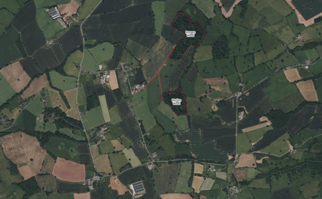
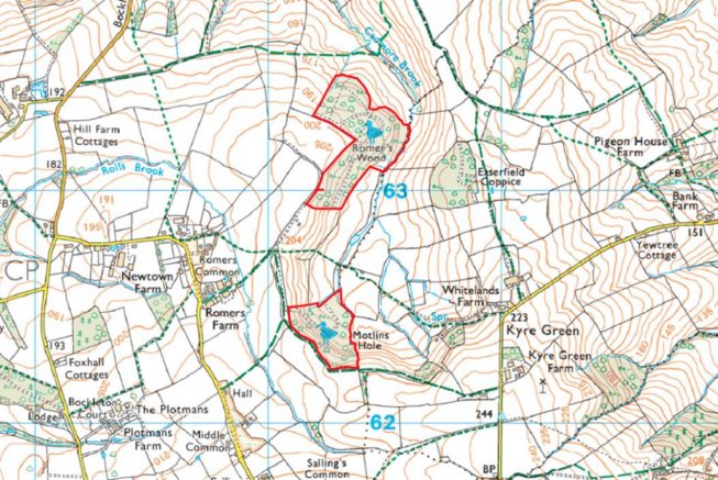
- Lot 1: Romers Wood extends to about 30.32 acres
- Lot 2: Motlins Wood extends to about 14.27 acre
- Private secluded location
Description
Overview - Motlins and Romers Wood are situated just outside the village of Bockleton in Worcestershire. Approximately 4.4 miles from the Market Town of Tenbury Wells and 9 miles from the Market Town of Leominster. Both offering a wide range of shops and restaurants.
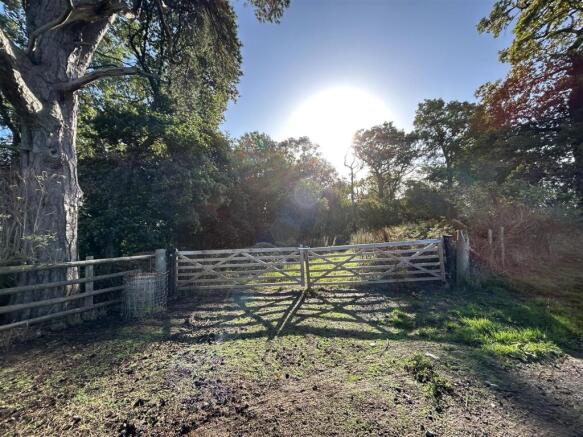
The woodland blocks are surrounded by rolling countryside at the end of a farm track.
The woodland extends in total to 44.59 acres (18.04 hectares) and is available as a Whole or in 2 Lots.
Lot 1: Romers Wood - Romers Wood extends to about 30.32 acres (12.27 ha) of undulating forest comprising mainly oak and ash.
The woodland exemplifies ancient woodland, spanning both a plateau and a steep southeast-facing slope that descends toward Cadmore Brook—a stream nestled in a steep-sided dingle. Within this woodland, you’ll find flora typical of ancient woodlands, including bluebells, wood anemone, and yellow archangel. The upper sections of the wood remain persistently damp and have been colonized by rushes, lady’s smock, and creeping jenny.
Along the Cadmore Brook, other damp areas host alders, meadowsweet, water avens, and opposite-leaved golden saxifrage. Notably, the Woodlands provide a habitat for various wildlife, including the rare Bechstein’s Bat and Dormice.
Lot 2: Motlins Wood - Motlins Wood extends to about 14.27 acres (5.77 ha). The woodland lies on a distinctive steep-sided bowl at the head of the valley of the Cadmore Brook.
The upper and western sections of the woodland are classified as ancient semi-natural woodland. These areas feature semi-mature oaks and ash trees, along with a diverse array of other species, including field maple and goat willow. Along the stream’s edge further downstream, you’ll discover meadowsweet, brooklime, opposite-leaved golden saxifrage, marsh marigold, and water avens.
The woodland teems with birdlife, including common woodpeckers, five species of tit, and several pairs of jackdaws and nuthatches. Additionally, wood warblers often establish nests here, and willow warblers have successfully bred in the new coupe areas.
Tenure - We understand the property is freehold with vacant possession.
Boundaries - The purchaser shall be deemed to have full knowledge of all boundaries and neither the Vendor nor the Vendor’s Agent will be responsible for defining the boundaries of ownership thereof.
Wayleaves, Easements & Rights Of Way - The property is sold subject to and with the benefit of all easements, quasi easements, wayleaves, and rights of way both declared and undeclared.
Planning - We understand that no planning enquiries have been made.
Local Authority & Public Utilities - Worcestershire Council, County Hall Spetchley Road Worcester WR5 2NP
Welsh Water Dwr Cymru, Pentwyn Road, Nelson, Treharris, Mid Glamorgan, CF46 6LY
National Grid, Ludlow, SY8 1FN
Site Plans - The plans included in the sale particulars are for identification purposes only and may have been reduced in scale to assist with printing.
Stewardship Schemes - We understand that the Woodland is subject to a Higher Tier Countryside Stewardship scheme ending in 2028. Th prospective purchaser can continue with the agreement or it can be terminated upon completion. For more details of the agreement please contact the agent.
Sporting, Timber & Mineral Rights - We understand that all standing timber or any sporting rights, if owned, are included in the sale.
Designations - We understand as part of the sale the woodland will be delisted as a Local Nature Reserve and thereafter public access will no longer be mandatory.
Access - We understand that access to both lots is via a private right of way (as shown by the red dots on the plan) with and without vehicles, horses, machinery and equipment in connection with the management and enjoyment of the woodlands.
Money Laundering - As a result of anti-laundering legislation Prospective purchasers will need to show proof of ID (photo ID for example passport or driving licence and residential ID for example current utility bill).
Agents Note - Any plans used in the preparation of these details may have been reduced in scale and any interested parties should check the Title Plan before proceeding to purchase.
Mode Of Sale - The property is for sale by Private Treaty The Vendor reserves the right to take offers to Best & Finals.
Health & Safety Notice - Prospective Purchasers should take all necessary care when making an inspection including wearing suitable clothing. Viewings are taken solely at the risk of those who view and neither the Agents nor the owners of the property take responsibility for any injury however caused. Please note the woodland footpaths are slippery underfoot and can become steep in places therefore the upmost care must be taken when viewing.
Important Notice - These particulars are set out as a guide only. They are intended to give a fair description of the property but may not be relied upon as a statement or representation of facts. These particulars are produced in good faith but are inevitably subjective and do not form part of any Contract. No persons within Sunderlands have any authority to make or give any representation or warranty whatsoever in relation to the property.
Directions - From Leominster: Take the A44 north towards Ludlow. The after approximately 2.1 miles turn right on the A4112 towards Leysters. Continue along this road for approximately 3.6 miles, then at the cross roads turn right on to a unnamed road. Continue along until after approximately 1.8 miles there will be a T junction, turn left towards Tenbury. Continue along until there is a T junction with the Bockleton road turn left after approximately 0.1 of a mile turn right continue for approximately 0.5 of a mile then turn left into Romers Farm if you continue straight on you will come to a right hand turn if you go down their you will come to Motlins Wood, but if you continue straight down the track you will come to Romers Wood.
Viewing - Viewing may take place on foot at any reasonable time during daylight hours with a copy of these sales details to hand. However, the prospective Purchasers are asked to respect the land and take care when parking. Please ensure all gates are left as found.
What3words - Lot 1: ///canines.steam.snap
Lot 2: ///looms.orbit.sneezed
Brochures
BockletonBockleton

NEAREST STATIONS
Distances are straight line measurements from the centre of the postcode- Leominster Station6.4 miles


Notes
Disclaimer - Property reference 34185872. The information displayed about this property comprises a property advertisement. Rightmove.co.uk makes no warranty as to the accuracy or completeness of the advertisement or any linked or associated information, and Rightmove has no control over the content. This property advertisement does not constitute property particulars. The information is provided and maintained by Sunderlands, Hereford. Please contact the selling agent or developer directly to obtain any information which may be available under the terms of The Energy Performance of Buildings (Certificates and Inspections) (England and Wales) Regulations 2007 or the Home Report if in relation to a residential property in Scotland.
Map data ©OpenStreetMap contributors.