Wotton-under-Edge, Gloucestershire, GL12
£0.23 per sq ft
Business rates & charges may apply
- SIZE AVAILABLE
221,720 sq ft
20,599 sq m
- SECTOR
Land for sale
Key features
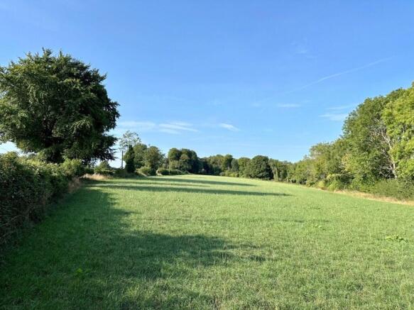
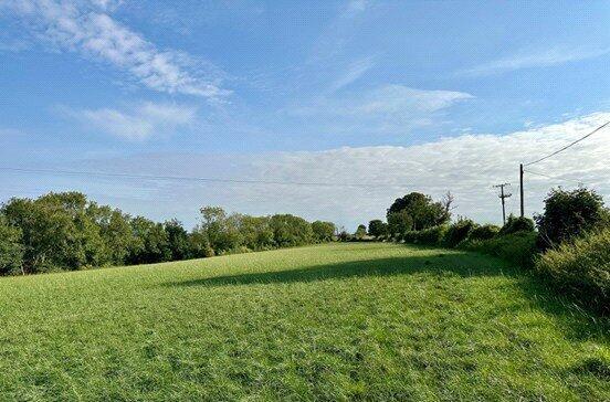
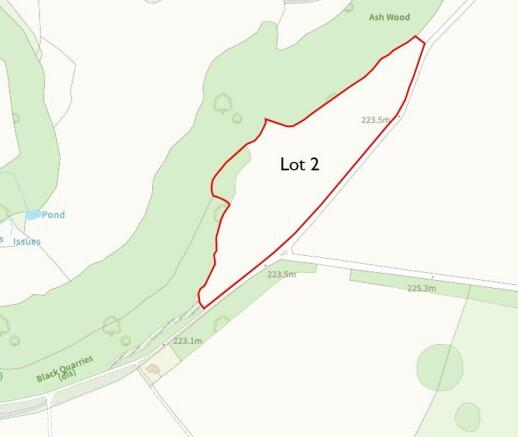
- LOT 2 - Agricultural land of approx. 5.09 acres
- Gently sloping Grade 3/4 agricultural land
- Suited to Agricultural, Equestrian, Amenity or Conservation Use (Subject to Planning)
- Direct road access
- What3Words ///consented.simmer.enjoyable (Lot 2)
Description
Description
5.09 acres of land capable of arable use, characterised by level to gentle gradient, bounded by woodland edges, mature hedgerows, stone walls and stock proof fencing, The parcel benefits from direct road frontage and access from Blackquarries Hill. In recent years, the land has been used for grazing and silaging and maize growing.
Situation
Located approximately 1.5 miles to the east of the Cotswold Market Town of Wotton-under-Edge, situated within the jurisdiction of Stroud District Council.
Services
There is no mains water supply connected to the land.
Sporting, Timber and Mineral Rights
We understand that sporting rights, mineral and standing timber rights are included.
Schemes
The land is within a groundwater Nitrate Vulnerable Zone. The land is not within any SFI or Countryside Stewardship Schemes and thus creating useful opportunities to submit a suitable application and benefit financially and environmentally.
Wayleaves, Easements & Rights of Way
The land is sold subject to and with the benefit of all matters contained in or referred to in the title deeds together with all existing rights of way whether public or private including wayleaves, easements, covenants, restrictions and obligations whether specifically referred to in these sale particulars or not. The buyer shall be deemed to have full knowledge of the boundaries and the ownership thereof.
Method of Sale
The property is offered for sale by Private Treaty as a whole. Vacant possession will be given upon completion.
Local Authority
Stroud District Council
What3Words
Lot 2: ///consented.simmer.enjoyable
Money Laundering Regulations
Buyer(s) will be required to provide proof of funds and identity information so Anti Money Laundering checks can be undertaken before an offer can be accepted on any property we are marketing.
Viewing
All viewings are strictly by appointment only and arranged through our Wotton-under-Edge office .
Brochures
Wotton-under-Edge, Gloucestershire, GL12

NEAREST STATIONS
Distances are straight line measurements from the centre of the postcode- Cam & Dursley Station5.6 miles
Notes
Disclaimer - Property reference WOR250023. The information displayed about this property comprises a property advertisement. Rightmove.co.uk makes no warranty as to the accuracy or completeness of the advertisement or any linked or associated information, and Rightmove has no control over the content. This property advertisement does not constitute property particulars. The information is provided and maintained by David James, Wotton-under-Edge. Please contact the selling agent or developer directly to obtain any information which may be available under the terms of The Energy Performance of Buildings (Certificates and Inspections) (England and Wales) Regulations 2007 or the Home Report if in relation to a residential property in Scotland.