
Bunts Lane, Seaton
- PROPERTY TYPE
Land
- BEDROOMS
7
- BATHROOMS
3
- SIZE
27,878 sq ft
2,590 sq m
Key features
- Planning for three dwellings
- Views to sea and valley
- Ref 15/1949/RES - Start made
- Ref 24/1593/FUL - dated 4th April 2025
- 0.64 acres (0.26 ha)
- Services nearby/cross
- Freehold
Description
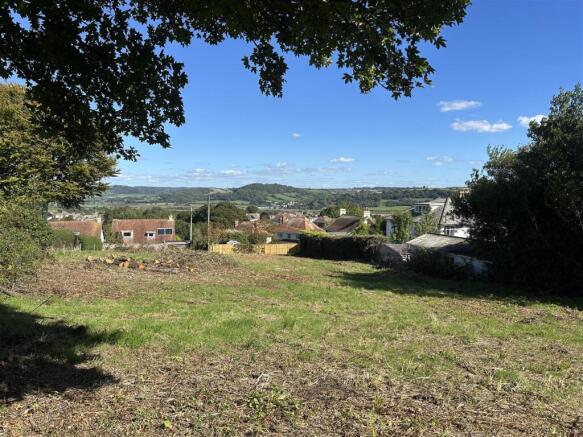
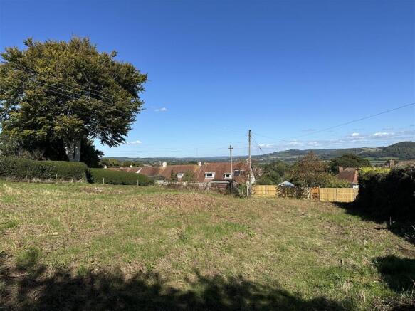
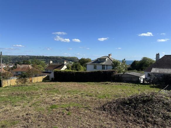
Situation - The site sits in a wonderful, elevated, sought after location above the popular seaside town of Seaton with expansive views across the roof tops to the sea and inland over rolling countryside up the beautiful Axe Valley.
Part of the world renowned Jurassic Coast, Seaton has a mile long beach, picturesque streets and glorious views.
This lively community has an appealing range of facilities including a supermarket, post office, doctors surgery, restaurants, inns, independent shops, the Jurassic Coast visitor centre as well as proposed water front developments at Axmouth and Seaton Quay.
The nearby historic fishing villages of Beer and Branscombe are nestled in the hills between Seaton and Sidmouth There is also a sailing club, harbour and golf course at nearby Axmouth and a mainline station at Axminster and Honiton.
The much acclaimed Colyton Grammar School, one of England's top state schools, is located just about 2 miles away.
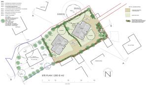
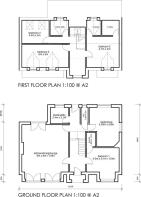
Description - Extending to a total of 0.64 acres (0.26 ha) this wonderful, elevated site has consent for two dwellings.
Proposed 3 Bedroom - GIA c. 171sqm (1841sqft). The first obtained outline consent (Ref 12/0966/OUT) with subsequent reserved matters (Ref 15/1949/RES) granted 3rd Nov 2015. The council has acknowledged commencement.
The other two more substantial dwellings have an estimated GIA 190 sqm (2,045 sqft) Ref 24/1593/FUL - dated 4th April 2025).
Both applications are subject to conditions. Copies of the relevant documents are available on the EDDC website.
Access - The site has two access points, however only one can be used to gain access to the finished dwellings via Marlpits Lane/Seaton Down Hill. We understand the utility companies can be approcha ed
Community Infrastructure Levy (Cil) - We have been informed that there is no liability for Community Infrastructure Levy for the first dwelling (Ref 15/1949/RES) as this was started before the introduction of CIL, however CIL is payable on the other two dwellings unless reliefs are applied for successfully.
Services - It is understood mains water, drainage, electric and telephone are all nearby or cross the site. Purchasers to make their own enquiries. The existing mains drainage which crosses the site we understand will need re routing with the consent of South West Water (SWW). Broadband superfast available in the area (Ofcom). Mobile coverage available with EE, O2, Three and Vodafone (Ofcom).
Directions - For viewings, come off the A3052 at Tower Services, down Seaton Down Hill. On the sweeping bend, turn right to Marlpits Lane and almost immediately right again around the bend into Bunts Lane. After about 100 yards turn right up a shared private lane (owned by the site).
Viewings - Please contact either Stags on , or the Joint Agents KLP on
Note - Please note a neighbour has a pedestrian right of access down across the site, see plans for agreed route.
Brochures
Bunts Lane, SeatonBunts Lane, Seaton

NEAREST STATIONS
Distances are straight line measurements from the centre of the postcode- Axminster Station5.7 miles


Notes
Disclaimer - Property reference 32948100. The information displayed about this property comprises a property advertisement. Rightmove.co.uk makes no warranty as to the accuracy or completeness of the advertisement or any linked or associated information, and Rightmove has no control over the content. This property advertisement does not constitute property particulars. The information is provided and maintained by Stags, Honiton. Please contact the selling agent or developer directly to obtain any information which may be available under the terms of The Energy Performance of Buildings (Certificates and Inspections) (England and Wales) Regulations 2007 or the Home Report if in relation to a residential property in Scotland.