
8.18 Acres of Land at Higher Gorsty, The Wash, Chapel-en-le-Frith, High Peak
- PROPERTY TYPE
Land
- SIZE
Ask agent
Key features
- Two parcels of grassland and part tree planting
- Peaceful location on the edge of the Peak District National Park
- Expected to be of appeal to equestrian and agricultural purchasers, investors or those with amenity and environmental interests
- Good transport links via the A6
- Mains Water Supply Connected to Lot 1 and Lot 2 has the benefit of a natural water supply
- Extending to approximately 8.18 acres in total
- Lot 1 - 4.20 acres
- Lot 2 - 3.98 acres
Description
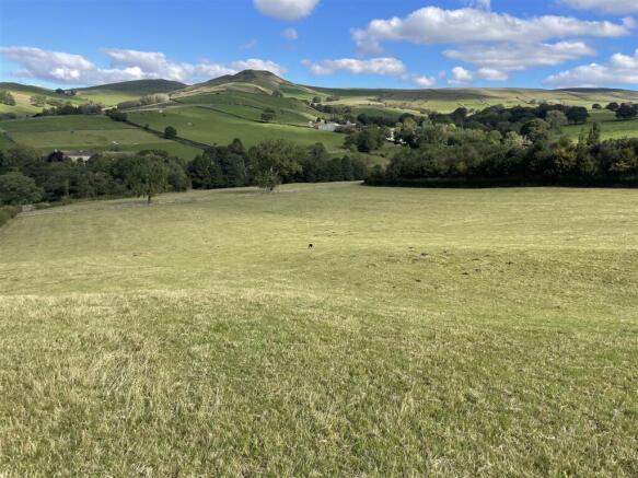
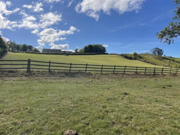
Lot 1 comprises of a sloping grassland field which has the benefit of mains water and is bordered by mature woodland and extending to 4.20 acres. Suitable for the grazing of livestock and horses.
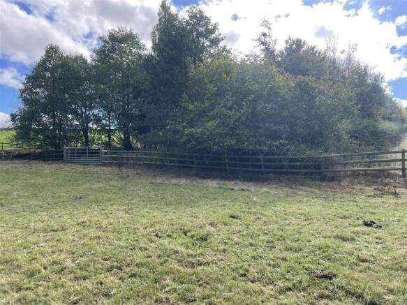
Lot 2 consists of grassland and woodland and extends to approximately 3.98 acres. This lot borders the brook along its northern boundary, and which provides a natural source of water for grazing livestock or horses.
Both lots are considered to be of appeal to equestrian & agricultural parties, investors, those with amenity and environmental
interests.
Directions - From the A6 roundabout (next to Aldi and Starbucks), take the third exit onto the A624. Take the second exit at the next roundabout to stay on A624. After approximately 0.5 of a mile, take a sharp right immediately after the railway bridge. After approximately 0.5 miles, the entranceway to Higher Gorsty Farm will be on the left. Lot 1 can be accessed from the driveway and Lot 2 can be accessed by carrying on the lane and the entrance gateway is on the left hand side. Both entrance gateways are indicated by an Agents ‘For Sale’ Board.
What3Words: ///panels.singles.compass (Entrance to Higher Gorsty)
Viewings - The land can be viewed at any reasonable time without prior appointment with the selling agent. We request that you take a copy of these sales details with you when viewing the land.
Anyone inspecting the land does so entirely at their own risk and neither the selling agents nor the vendors accept any responsibility or liability for any injuries or consequential loss how so ever caused.
Services - Lot 1 has the benefit of a mains water supply. Lot 2 has the benefit of a natural water supply via the brook on the northern boundary.
Soil Type Land Grade - According to the Cranfield Soil and Agri-food Institute (Soilscapes of England & Wales), the soil is classed as “Soilscape 6” described as freely draining, slightly acid, loamy soils suitable for a range of spring and autumn sown crops. The land is Grade 4 (Land Classification Series for England & Wales) (Grade 1 - best, Grade 5 – least productive).
Situation - The land is situated off a quiet country lane, yet only 2.5 miles from the centre of Chapel-en-le-Frith, 7.7 miles from the market town of Buxton and 15 miles from the centre of Stockport. The land is situated just minutes from the A6 offering easy transport links and Chapel-en-le-Frith train station is just 3 miles away, offering easy links to Buxton, Stockport, Manchester and beyond.
Tenure & Title - The land forms part of Freehold title number DY406104 and vacant possession will be granted upon completion.
Access - Lot 1 – The first parcel of land is accessed via a Right of Way to be granted to the Purchaser from the entrance of the driveway leading to Higher Gorsty along the route shaded brown on the plan. The second parcel of land in Lot 1 is accessed via a Right of Way to be granted to the Purchaser along the route shaded yellow on the plan.
Lot 2 - Accessed via a roadside gateway off the council maintained lane.
Town And Country Planning Act - The property not withstanding any description contained in these particulars, is sold subject to any development plan, tree preservation order, town planning scheme or agreement, resolution or notice.
Sale Plan And Particulars - The sale plan is based on the Ordnance Survey sheet. Prospective purchasers should check the contract documents. The purchasers shall raise no objection or query in respect of any variation between the physical boundaries and the Ordnance Survey sheet plan. The plans are strictly for identification purposes only.
Money Laundering Legislation - Whittaker & Biggs must comply with Anti Money Laundering legislation. As part of the requirements, Whittaker & Biggs must obtain evidence of the identity & proof of address of potential buyers. Prior to an offer being accepted, all parties who are purchasing must provide the evidence upon request.
Easements, Wayleaves And Rights Of Way - The land is sold subject to and with the benefit of all public and private rights of way, lights, drainage, cable, pylons or other easements, restrictions or obligations whether or not the same are described in these particulars of sale. The area marked green on the plan shows a right of way for a third party to access another parcel of land.
Selling Agents - Peter Kirton-Darling MRICS FAAV
Shannon Fairey
Whittaker and Biggs
45 - 49 Derby Street
Leek
Staffordshire
ST13 6HU
shannon.
Brochures
Brochure.pdfBrochure8.18 Acres of Land at Higher Gorsty, The Wash, Chapel-en-le-Frith, High Peak

NEAREST STATIONS
Distances are straight line measurements from the centre of the postcode- Chinley Station1.2 miles
- Chapel-en-le-Frith Station1.9 miles
- Whaley Bridge Station3.0 miles


Notes
Disclaimer - Property reference 34209359. The information displayed about this property comprises a property advertisement. Rightmove.co.uk makes no warranty as to the accuracy or completeness of the advertisement or any linked or associated information, and Rightmove has no control over the content. This property advertisement does not constitute property particulars. The information is provided and maintained by Whittaker & Biggs, Leek. Please contact the selling agent or developer directly to obtain any information which may be available under the terms of The Energy Performance of Buildings (Certificates and Inspections) (England and Wales) Regulations 2007 or the Home Report if in relation to a residential property in Scotland.
Map data ©OpenStreetMap contributors.